Hampden County is a non-governmental county located in the Pioneer Valley of the state of Massachusetts, in the United States. As of the 2020 census, Hampden County's population was 465,825. Its traditional county seat is Springfield, the Connecticut River Valley's largest city, and economic and cultural capital; with an estimated population of 154,758, approximately 1 in 3 residents of Hampden County live in Springfield.

Springfield is the most populous city in and the seat of Hampden County, Massachusetts, United States. Springfield sits on the eastern bank of the Connecticut River near its confluence with three rivers: the western Westfield River, the eastern Chicopee River, and the eastern Mill River. At the 2020 census, the city's population was 155,929, making it the 3rd most populous city in the U.S. state of Massachusetts and the 4th most populous city in New England after Boston, Worcester, and Providence. Metropolitan Springfield, as one of two metropolitan areas in Massachusetts, had a population of 699,162 in 2020.

Chicopee is a city located on the Connecticut River in Hampden County, Massachusetts, United States. At the 2020 census, the city had a population of 55,560, making it the second-largest city in western Massachusetts after Springfield. Chicopee is part of the Springfield, Massachusetts Metropolitan Statistical Area. The communities of Chicopee Center (Cabotville), Chicopee Falls, Willimansett, Fairview, Aldenville, Burnett Road, Smith Highlands and Westover are located within the city.

Holyoke is a city in Hampden County, Massachusetts, United States, that lies between the western bank of the Connecticut River and the Mount Tom Range. As of the 2020 census, the city had a population of 38,247. Located 8 miles (13 km) north of Springfield, Holyoke is part of the Springfield Metropolitan Area, one of the two distinct metropolitan areas in Massachusetts.

Holyoke station is an Amtrak intercity train station near the corner of Main and Dwight streets in Holyoke, Massachusetts, United States. The station opened on August 27, 2015, eight months after Amtrak's Vermonter service was re-routed to the Connecticut River Line through the Pioneer Valley.

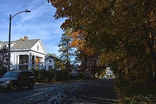
Elmwood is a neighborhood in Holyoke, Massachusetts located to the south of the city center, approximately 1 mile (1.6 km) from downtown. Elmwood is historically Holyoke's oldest village; predating the construction of the Hadley Falls Dam, it originated as part of the 3rd parish of West Springfield, and originally was known as Baptist Village as Holyoke's first and oldest congregation is the First Baptist Church, formally established in 1803, but maintaining a meetinghouse since 1792. Today the neighborhood contains many historic Victorian houses and about 510 acres (210 ha) of mixed residential and commercial zoning, as well as Holyoke High School, William R. Peck Middle School, Fitzpatrick Ice Skating Rink, and Mackenzie Stadium.

Smith's Ferry is a neighborhood in Holyoke, Massachusetts, United States, located to the north of the city center, approximately 1.5 miles (2.4 km) from downtown. The neighborhood prominently features the Mount Tom State Reservation, as well as the Mountain Park Amphitheater, the Dinosaur Footprints Reservation, and several other recreational and historic venues. Smith's Ferry is the second largest geographic division in Holyoke after Rock Valley, comprising roughly 3,800 acres (1,500 ha) of mixed residential, commercial, and recreational zoning.

Ingleside is a neighborhood in Holyoke, Massachusetts located to the south of the city center, approximately 2 miles from downtown. The neighborhood features access to the Connecticut River through the Sue Ellen Panitch River Center and the Land of Providence reservation. Ingleside is also home to the Holyoke Mall, the Nuestras Raices farm, the Sisters of Providence of Holyoke, the Providence Behavioral Health Hospital, and several recreational and historical venues.

Springdale is a neighborhood in Holyoke, Massachusetts located to the south of the city center, approximately 1 mile (1.6 km) from downtown, on the banks of the Connecticut River. The neighborhood features Springdale Park, originally known as Riverside Park, which was designed by the influential Olmsted Brothers landscape architecture firm, as well as light industry and machine shops, residential housing, and the central supply warehouse of Holyoke Public Schools. The mixed zoning neighborhood was developed as a streetcar suburb by brickmaker John J. Prew, who gave the area its name and devised the first street plans and building lots for the area in 1887 as housing for millworkers of South Holyoke. Since 1984, Springdale Park has hosted the city's annual Western Massachusetts Puerto Rican Parade, a three-day annual event in June celebrating the city's Latin culture and music.

Rock Valley, sometimes referred to as West Holyoke, is a neighborhood in Holyoke, Massachusetts located to the west of the city center, approximately 3 miles (4.8 km) from downtown, bordering Easthampton, Southampton, Westfield, and West Springfield. Rock Valley is historically Holyoke's second oldest village after Elmwood, with its eponymous burial ground dating to around 1777, and families having settled in the area as early as 1745. Predating the construction of the Hadley Falls Dam, it originated as the western section of the 3rd parish of West Springfield. Today, the neighborhood contains several historic Federal and Colonial homesteads, in addition to many modern developments adjacent to agricultural and wetland tracts.

Oakdale is a neighborhood in Holyoke, Massachusetts located to the west of the city center, adjacent to downtown. Developed as a streetcar suburb in the late nineteenth century, today the neighborhood contains many Victorian houses, and about 460 acres (190 ha) of mixed residential and commercial zoning, as well as Forestdale Cemetery, Saint Jerome Cemetery, Rohan Park, and Holyoke Medical Center.
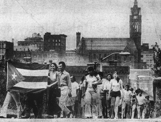
As of the 2010 census, Holyoke, Massachusetts had the largest Puerto Rican population, per capita, of any city in the United States outside Puerto Rico proper, with 47.7% or 44,826 residents being of Puerto Rican heritage, comprising 92.4% of all Latinos in the community. From a combination of farming programs instituted by the US Department of Labor after World War II, and the housing and mills that characterized Holyoke prior to deindustrialization, Puerto Ricans began settling in the city in the mid-1950s, with many arriving during the wave of Puerto Rican migration to the Northeastern United States in the 1980s. A combination of white flight as former generations of mill workers left the city, and a sustained influx of migrants in subsequent generations transformed the demographic from a minority of about 13% of the population in 1980, to the largest single demographic by ancestry in a span of three decades.

Churchill is a neighborhood in Holyoke, Massachusetts located to the south of the city center, adjacent to the downtown. Its name is a geographic portmanteau as the area was historically known as the Church Hill district prior to its extensive development in the early twentieth century. Located at the southwestern edge of the downtown grid, the area served as housing for mill workers in the late nineteenth and early twentieth century and today contains 166 acres (67 ha) of mixed residential and commercial zoning, including a number of historical brick tenements as well as the headquarters of the Holyoke Housing Authority, Holyoke Senior Center, Churchill Homes public housing, and the Wistariahurst Museum.

The Highlands is a neighborhood in Holyoke, Massachusetts located northwest of the city center, adjacent to the downtown. Originally a series of farms and estates, it was first known as Manchester Grounds, as the area's land was reportedly purchased by a company of landowners from Manchester, New Hampshire soon after Holyoke was first chartered, in 1852. However while this name persisted for much of the 19th century, these holders would default on their estates by 1856. The area was further divided into new building lots in the 1870s and saw considerable development as a streetcar suburb when the Holyoke Street Railway completed an extension to the area in 1886. Another early name for the section between Lincoln and Hampden streets was Money Hole Hill, a name also used by Mary Doyle Curran in her portrayal of the neighborhood in her novel The Parish and the Hill. By 1897 the neighborhood had been christened its present name for its higher elevation at the foot of the Mount Tom Range. Today the neighborhood contains many historic Victorian houses and about 400 acres (160 ha) of predominantly residential zoning with some commercial development, as well as the Kennedy and Morgan Street Parks.

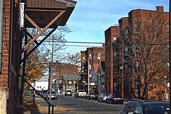
South Holyoke is a neighborhood in Holyoke, Massachusetts, located approximately 0.5 miles (0.80 km) south of the city center. Today the neighborhood contains many historical brick tenements and 165 acres (67 ha) of mixed residential, commercial, and industrial zoning including many of the remaining businesses of the city's paper industry. The neighborhood is also home to the city's Puerto Rican-Afro Caribbean Cultural Center, the Carlos Vega and Valley Arena Parks, as well as the Holyoke Turner Hall, one of the last remaining turnvereines in New England, and the William G. Morgan Elementary School. In 2018, South Holyoke had the highest percentage of renter-occupied housing of any Massachusetts neighborhood outside of Boston, with an average of 1.5% owner-occupied households across the neighborhood's two census block groups.

During the late 19th and early 20th centuries Holyoke saw an influx of Franco-Americans, predominantly French-Canadians, who immigrated to Massachusetts to work in the city's growing textile and paper mills. By 1900, 1 in 3 people in Holyoke were of French-Canadian descent, and a 1913 survey of French Americans in the United States found Holyoke, along with other Massachusetts cities, to have a larger community of French or French-Canadian born residents than those of New Orleans or Chicago at that time. Initially faced with discrimination for the use of their labor by mill owners to undermine unionization, as well as for their creation of separate French institutions as part of the La Survivance movement, this demographic quickly gained representation in the city's development and civic institutions. Holyoke was at one time a cultural hub for French-Canadian Americans; the Saint-Jean-Baptiste Society of America was first organized in the city in 1899, along with a number of other institutions, including theater and drama societies from which famed vaudevillian Eva Tanguay was first discovered, and regular publications, with its largest French weekly newspaper, La Justice, published from 1904 to 1964. The city was also home to author Jacques Ducharme, whose 1943 book The Shadows of the Trees, published by Harper, was one of the first non-fiction English accounts of New England's French and French-Canadian diaspora.
This is a timeline of the history of the city of Holyoke, Massachusetts, USA.
Highland Park is a neighborhood in Holyoke, Massachusetts located to the northwest of the city center, approximately 1 mile (1.6 km) from downtown, on the banks of the Connecticut River. The neighborhood features Jones Park, originally itself known as Highland Park, which was designed by the influential Olmsted Brothers firm. The residential neighborhood was initially developed as a streetcar suburb by the Highland Park Improvement Association, which underwent several iterations between 1893 and 1930. Today the neighborhood contains numerous Victorian and early 20th century housing and about 219 acres (89 ha) of residential zoning, as well as the Edward Nelson White School.
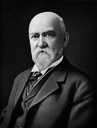
Eugene C. Gardner (1836–1915) was an American architect and author of Springfield, Massachusetts. Gardner was noted both for the architectural influence of his extensive practice as well as his writings on the American home. Gardner was the most notable architect of Springfield.