Chicopee is a city located on the Connecticut River in Hampden County, Massachusetts, United States. At the 2020 census, the city had a population of 55,560, making it the second-largest city in western Massachusetts after Springfield. Chicopee is part of the Springfield, Massachusetts Metropolitan Statistical Area. The communities of Chicopee Center (Cabotville), Chicopee Falls, Willimansett, Fairview, Aldenville, Burnett Road, Smith Highlands and Westover are located within the city.

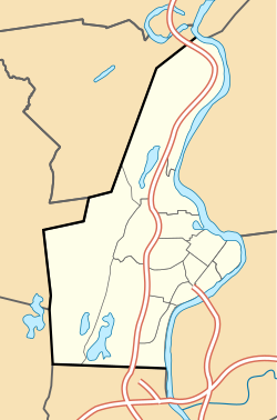
Holyoke is a city in Hampden County, Massachusetts, United States, that lies between the western bank of the Connecticut River and the Mount Tom Range. As of the 2020 census, the city had a population of 38,247. Located 8 miles (13 km) north of Springfield, Holyoke is part of the Springfield Metropolitan Area, one of the two distinct metropolitan areas in Massachusetts.
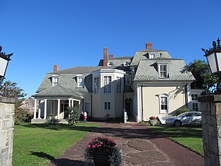
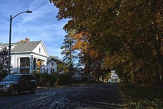
Wistariahurst is a historic house museum and the former estate of the Skinner family, located at 238 Cabot Street in Holyoke, Massachusetts. It was built in 1868 for William Skinner, the owner of a successful silk spinning and textile business, and is named for the abundant wisteria vines which cascade across its eastern facade. Originally constructed in Williamsburg in 1868, the mansion designed by Northampton architect William Ferro Pratt was moved to Holyoke in 1874, following the devastating flood which swept away the original Skinner mills. Following the death of Belle Skinner, its music room was operated as a private museum from 1930 to 1959, housing the Belle Skinner Collection of Old Musical Instruments, before their donation by the family to Yale University. Since 1959 it has been operated as the Wistariahurst Museum, and is open to the public. The property was listed on the National Register of Historic Places in 1973.

Holyoke City Hall is the historic city hall of Holyoke, Massachusetts. It is located at 536 Dwight Street, on the south east corner of High Street and Dwight Street. Serving both as the city administrative center and a public timepiece for the industrial city's workers, construction began on the Gothic Revival structure in 1871 to a design by architect Charles B. Atwood. Difficulties and delays in construction were compounded by Atwood's failure to deliver updated drawings in a timely manner, and the design work was turned over to Henry F. Kilburn in 1874. The building was completed two years later at a cost of $500,000. It has housed city offices since then.

Elmwood is a neighborhood in Holyoke, Massachusetts located to the south of the city center, approximately 1 mile (1.6 km) from downtown. Elmwood is historically Holyoke's oldest village; predating the construction of the Hadley Falls Dam, it originated as part of the 3rd parish of West Springfield, and originally was known as Baptist Village as Holyoke's first and oldest congregation is the First Baptist Church, formally established in 1803, but maintaining a meetinghouse since 1792. Today the neighborhood contains many historic Victorian houses and about 510 acres (210 ha) of mixed residential and commercial zoning, as well as Holyoke High School, William R. Peck Middle School, Fitzpatrick Ice Skating Rink, and Mackenzie Stadium.

Smith's Ferry is a neighborhood in Holyoke, Massachusetts, United States, located to the north of the city center, approximately 1.5 miles (2.4 km) from downtown. The neighborhood prominently features the Mount Tom State Reservation, as well as the Mountain Park Amphitheater, the Dinosaur Footprints Reservation, and several other recreational and historic venues. Smith's Ferry is the second largest geographic division in Holyoke after Rock Valley, comprising roughly 3,800 acres (1,500 ha) of mixed residential, commercial, and recreational zoning.

Ingleside is a neighborhood in Holyoke, Massachusetts located to the south of the city center, approximately 2 miles from downtown. The neighborhood features access to the Connecticut River through the Sue Ellen Panitch River Center and the Land of Providence reservation. Ingleside is also home to the Holyoke Mall, the Nuestras Raices farm, the Sisters of Providence of Holyoke, the Providence Behavioral Health Hospital, and several recreational and historical venues.

Springdale is a neighborhood in Holyoke, Massachusetts located to the south of the city center, approximately 1 mile (1.6 km) from downtown, on the banks of the Connecticut River. The neighborhood features Springdale Park, originally known as Riverside Park, which was designed by the influential Olmsted Brothers landscape architecture firm, as well as light industry and machine shops, residential housing, and the central supply warehouse of Holyoke Public Schools. The mixed zoning neighborhood was developed as a streetcar suburb by brickmaker John J. Prew, who gave the area its name and devised the first street plans and building lots for the area in 1887 as housing for millworkers of South Holyoke. Since 1984, Springdale Park has hosted the city's annual Western Massachusetts Puerto Rican Parade, a three-day annual event in June celebrating the city's Latin culture and music.

Rock Valley, sometimes referred to as West Holyoke, is a neighborhood in Holyoke, Massachusetts located to the west of the city center, approximately 3 miles (4.8 km) from downtown, bordering Easthampton, Southampton, Westfield, and West Springfield. Rock Valley is historically Holyoke's second oldest village after Elmwood, with its eponymous burial ground dating to around 1777, and families having settled in the area as early as 1745. Predating the construction of the Hadley Falls Dam, it originated as the western section of the 3rd parish of West Springfield. Today, the neighborhood contains several historic Federal and Colonial homesteads, in addition to many modern developments adjacent to agricultural and wetland tracts.

Oakdale is a neighborhood in Holyoke, Massachusetts located to the west of the city center, adjacent to downtown. Developed as a streetcar suburb in the late nineteenth century, today the neighborhood contains many Victorian houses, and about 460 acres (190 ha) of mixed residential and commercial zoning, as well as Forestdale Cemetery, Saint Jerome Cemetery, Rohan Park, and Holyoke Medical Center.
The Holyoke Street Railway (HSR) was an interurban streetcar and bus system operating in Holyoke, Massachusetts as well as surrounding communities with connections in Amherst, Belchertown, Chicopee, Easthampton, Granby, Northampton, Pelham, South Hadley, Sunderland, Westfield, and West Springfield. Throughout its history the railway system shaped the cultural institutions of Mount Tom, being operator of the mountain's famous summit houses, one of which hosted President McKinley, the Mount Tom Railroad, and the trolley park at the opposite end of this funicular line, Mountain Park.

Churchill is a neighborhood in Holyoke, Massachusetts located to the south of the city center, adjacent to the downtown. Its name is a geographic portmanteau as the area was historically known as the Church Hill district prior to its extensive development in the early twentieth century. Located at the southwestern edge of the downtown grid, the area served as housing for mill workers in the late nineteenth and early twentieth century and today contains 166 acres (67 ha) of mixed residential and commercial zoning, including a number of historical brick tenements as well as the headquarters of the Holyoke Housing Authority, Holyoke Senior Center, Churchill Homes public housing, and the Wistariahurst Museum.

South Holyoke is a neighborhood in Holyoke, Massachusetts, located approximately 0.5 miles (0.80 km) south of the city center. Today the neighborhood contains many historical brick tenements and 165 acres (67 ha) of mixed residential, commercial, and industrial zoning including many of the remaining businesses of the city's paper industry. The neighborhood is also home to the city's Puerto Rican-Afro Caribbean Cultural Center, the Carlos Vega and Valley Arena Parks, as well as the Holyoke Turner Hall, one of the last remaining turnvereines in New England, and the William G. Morgan Elementary School. In 2018, South Holyoke had the highest percentage of renter-occupied housing of any Massachusetts neighborhood outside of Boston, with an average of 1.5% owner-occupied households across the neighborhood's two census block groups.

During the late 19th and early 20th centuries Holyoke saw an influx of Franco-Americans, predominantly French-Canadians, who immigrated to Massachusetts to work in the city's growing textile and paper mills. By 1900, 1 in 3 people in Holyoke were of French-Canadian descent, and a 1913 survey of French Americans in the United States found Holyoke, along with other Massachusetts cities, to have a larger community of French or French-Canadian born residents than those of New Orleans or Chicago at that time. Initially faced with discrimination for the use of their labor by mill owners to undermine unionization, as well as for their creation of separate French institutions as part of the La Survivance movement, this demographic quickly gained representation in the city's development and civic institutions. Holyoke was at one time a cultural hub for French-Canadian Americans; the Saint-Jean-Baptiste Society of America was first organized in the city in 1899, along with a number of other institutions, including theater and drama societies from which famed vaudevillian Eva Tanguay was first discovered, and regular publications, with its largest French weekly newspaper, La Justice, published from 1904 to 1964. The city was also home to author Jacques Ducharme, whose 1943 book The Shadows of the Trees, published by Harper, was one of the first non-fiction English accounts of New England's French and French-Canadian diaspora.

The Flats is a neighborhood in Holyoke, Massachusetts located to the east of the city center, adjacent to the downtown. Although it lies at one of the lowest elevations in Holyoke, its name derives not from topography but from the brick tenement "flats" which characterized its architecture throughout much of its history. Historically the area has also been associated with the name Depot Hill, as it was the location of the city's first freight and passenger railway stations; passenger service was restored at Holyoke station in 2015, following a period of absence after 1967. A section of the neighborhood between Lyman and Appleton Street to north and south respectively, and between Race and Bowers Street to the east and west is also known as Depot Square. Today the area features the Holyoke Innovation District, Canal System, Hadley Falls Company Housing District, Marcella Kelly Elementary School, local Amtrak station and 275 acres (111 ha) of residential, commercial, and industrial zoning.
Despite representing a significantly smaller population than their Irish, French, Polish, or Puerto Rican counterparts, in the late 19th century through the mid-20th century, German immigrants predominantly from Saxony and Rhineland played a significant economic, cultural, and political role in the history of Holyoke, Massachusetts. The influx of these immigrants can largely be attributed to a single mill and millworker complex, the Germania Woolen Mills, which formed the basis of the immigrant colony that would make the ward encompassing the South Holyoke neighborhood that with the highest German population per capita, in all of New England by 1875. Along with unionization efforts by the Irish community, Germans would also play a key role in the city and region's socialist labor movements as workers organized for higher pay and improved living conditions in the textile and paper mill economies.

Whiting Farms is a neighborhood in Holyoke, Massachusetts, located to the southwest of the city center, approximately 2 miles (3.2 km) from downtown. Following the construction of Whiting Farms Road in 1961, the area was developed as a residential and commercial area in the 1960s and 1970s. Its name derives from its original use as site of the farm of William Whiting, where the former mayor and papermaker bred a prizewinning herd of Jersey cattle in the late 19th and early 20th century, many of which were sold for breeding to all parts of the country. A disastrous fire caused by arson in 1919 would kill off the entire herd of 75 head, and following this the farm, then-owned by William F. Whiting, became largely defunct. At the end of the Second World War it was proposed that the property be redeveloped into an airpark, however these plans would never come to fruition. Shortly after another case of arson in 1967 which destroyed a remaining barn, the property began to see the medium-density residential development that characterizes it today, with the First Whiting Farms Cooperative Housing breaking ground later that year. Initially criticized as the "Road to Nowhere" during Samuel Resnic's administration in the early 1960s, Whiting Farms Road today serves as a major artery for retail businesses and traffic to I-91 in the area.
This is a timeline of the history of the city of Holyoke, Massachusetts, USA.
Highland Park is a neighborhood in Holyoke, Massachusetts located to the northwest of the city center, approximately 1 mile (1.6 km) from downtown, on the banks of the Connecticut River. The neighborhood features Jones Park, originally itself known as Highland Park, which was designed by the influential Olmsted Brothers firm. The residential neighborhood was initially developed as a streetcar suburb by the Highland Park Improvement Association, which underwent several iterations between 1893 and 1930. Today the neighborhood contains numerous Victorian and early 20th century housing and about 219 acres (89 ha) of residential zoning, as well as the Edward Nelson White School.