Related Research Articles

Yosemite National Park is a national park in California. It is bordered on the southeast by Sierra National Forest and on the northwest by Stanislaus National Forest. The park is managed by the National Park Service and covers 759,620 acres in four counties – centered in Tuolumne and Mariposa, extending north and east to Mono and south to Madera. Designated a World Heritage Site in 1984, Yosemite is internationally recognized for its cliffs, waterfalls, clear streams, giant sequoia groves, lakes, mountains, meadows, glaciers, and biological diversity. Almost 95 percent of the park is designated wilderness. Yosemite is one of the largest and least fragmented habitat blocks in the Sierra Nevada.

The Sierra Nevada is a mountain range in the Western United States, between the Central Valley of California and the Great Basin. The vast majority of the range lies in the state of California, although the Carson Range spur lies primarily in Nevada. The Sierra Nevada is part of the American Cordillera, an almost continuous chain of mountain ranges that forms the western "backbone" of the Americas.

Half Dome is a quartz monzonite batholith at the eastern end of Yosemite Valley in Yosemite National Park, California. It is a well-known rock formation in the park, named for its distinct shape. One side is a sheer face while the other three sides are smooth and round, making it appear like a dome cut in half. It stands at nearly 8,800 feet above sea level and is composed of quartz monzonite, an igneous rock that solidified several thousand feet within the Earth. At its core are the remains of a magma chamber that cooled slowly and crystallized beneath the Earth's surface. The solidified magma chamber was then exposed and cut in half by erosion, therefore leading to the geographic name Half Dome.
The Pacific Crest Trail (PCT), officially designated as the Pacific Crest National Scenic Trail, is a long-distance hiking and equestrian trail closely aligned with the highest portion of the Cascade and Sierra Nevada mountain ranges, which lie 100 to 150 miles east of the U.S. Pacific coast. The trail's southern terminus is next to the Mexico–United States border, just south of Campo, California, and its northern terminus is on the Canada–US border, upon which it continues unofficially to the Windy Joe Trail within Manning Park in British Columbia; it passes through the states of California, Oregon, and Washington.

The John Muir Trail (JMT) is a long-distance trail in the Sierra Nevada mountain range of California, passing through Yosemite, Kings Canyon and Sequoia National Parks. It is named after John Muir, a naturalist.

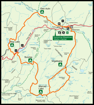
Tuolumne Meadows is a gentle, dome-studded, sub-alpine meadow area along the Tuolumne River in the eastern section of Yosemite National Park in the United States. Its approximate location is 37°52.5′N119°21′W. Its approximate elevation is 8,619 feet (2,627 m). The term Tuolumne Meadows is also often used to describe a large portion of the Yosemite high country around the meadows, especially in context of rock climbing.

The Mist Trail is one of the most popular short hikes in Yosemite National Park, California, USA. The steep hike follows the Merced River, starting at Happy Isles in Yosemite Valley, past Vernal Fall and Emerald Pool, to Nevada Fall.

The Merced River, in the central part of the U.S. state of California, is a 145-mile (233 km)-long tributary of the San Joaquin River flowing from the Sierra Nevada into the San Joaquin Valley. It is most well known for its swift and steep course through the southern part of Yosemite National Park, where it is the primary watercourse flowing through Yosemite Valley. The river's character changes dramatically once it reaches the plains of the agricultural San Joaquin Valley, where it becomes a slow-moving meandering stream.

The Grand Canyon of the Tuolumne is the notable canyon section of the river valley of the Tuolumne River, located within Yosemite National Park, in Tuolumne County and the Sierra Nevada, California.

Nevada Fall is a 594-foot (181 m) high waterfall on the Merced River in Yosemite National Park, California. It is located below the granite dome, Liberty Cap, at the west end of Little Yosemite Valley. The waterfall is widely recognized by its "bent" shape, in which the water free-falls for roughly the first third of its length to a steep slick-rock slope. This mid-fall impact of the water on the cliff face creates a turbulent, whitewater appearance in the fall and produces a great deal of mist which covers a wide radius, which led to its current name.

Glacier Point is a viewpoint above Yosemite Valley in the U.S. state of California. It is located on the south wall of Yosemite Valley at an elevation of 7,214 feet (2,199 m), 3,200 feet (980 m) above Curry Village. The point offers a superb view of several of Yosemite National Park's well-known landmarks, including Yosemite Valley, Yosemite Falls, Half Dome, Vernal Fall, Nevada Fall, and Clouds Rest. Between 1872 and 1968, it was the site of the Yosemite Firefall.

The following is a bibliography of the Sierra Nevada of California, United States, including books on recreation, natural history, and human history.

Vernal Fall is a 317-foot (96.6 m) waterfall on the Merced River just downstream of Nevada Fall in Yosemite National Park, California. Like its upstream neighbor, Vernal Fall is clearly visible at a distance, from Glacier Point, as well as close up, along the Mist Trail. The waterfall flows all year long, although by the end of summer it is substantially reduced in volume and can split into multiple strands, rather than a single curtain of water.

Theodore Seixas Solomons (1870–1947) was an explorer and early member of the Sierra Club. From 1892 to 1897 he explored and named the Mount Goddard, Evolution Valley and Evolution Basin region in what is now northern Kings Canyon National Park in eastern California. He was instrumental in envisioning, exploring, and establishing the route of what became the John Muir Trail from Yosemite Valley along the crest of the Sierra Nevada to Mount Whitney
The Sierra Crest is a roughly 500 mi (800 km) generally north-to-south ridgeline that demarcates the broad west and narrow east slopes of the Sierra Nevada and that extends as far east as the Sierra's topographic front. The northern and central Sierra Crest sections coincide with over 300 mi (480 km) of the Great Basin Divide, and the southern crest demarcates Tulare and Inyo counties and extends through Kern County to meet the Tehachapi crest. The Sierra Crest also forms two paths (bifurcates) around endorheic cirques between the west and east Sierra slopes.
The High Sierra Camps are nine rustic lodging facilities located in two national parks and a national monument in California's Sierra Nevada mountain range. Open most years from June or July to September, they are staffed camps with tent cabins and food service facilities. The backcountry camps receive their supplies by pack mules.

The Tahoe–Yosemite Trail (TYT) is a long-distance trail in the Sierra Nevada mountain range of California. The trail courses 186 miles (299 km) from Meeks Bay at Lake Tahoe to Tuolumne Meadows in Yosemite National Park. The trail is a foot and equestrian path that passes through the Desolation, Mokelumne, Carson-Iceberg, Emigrant, and Yosemite Wilderness Areas and the Meiss Country (Dardanelles) Roadless Area.

Tehipite Valley, a glacial valley of the Middle Fork Kings River, is located in Kings Canyon National Park in the Sierra Nevada of California. The valley is in Fresno County about 45 miles (72 km) southwest of Bishop and 60 miles (97 km) east of Fresno and is known for its Yosemite-like scenery and its extreme isolation.

The Panorama Trail is a marked hiking trail in Yosemite National Park that descends along the south wall of Yosemite Valley from Glacier Point, past several major waterfalls, to Happy Isles. The trail derives its name from the panoramic vistas visible along the route, most notably Panorama Point.
References
- Buscombe, Gary (1983). A Hiking Guide to the Theodore Solomons Trail. High Adventure Press.
- Gagnon, Dennis (1992). Guide to the Theodore Solomons Trail . Western Tanager. ISBN 0934136343.
