Thorganby, North Yorkshire

Last updated

Thorganby
Thorganby village street.jpg
Main street, Thorganby
North Yorkshire UK location map (2023).svg
Red pog.svg
Thorganby
Location within North Yorkshire
Population330 (2011 census) [1]
OS grid reference SE492749
Unitary authority
Ceremonial county
Region
Country England
Sovereign state United Kingdom
Post town YORK
Postcode district YO19
Police North Yorkshire
Fire North Yorkshire
Ambulance Yorkshire
List of places
UK
England
Yorkshire
53°52′10″N0°57′03″W / 53.86947°N 0.95075°W / 53.86947; -0.95075

Thorganby is a small village and civil parish in North Yorkshire, England. It was historically part of the East Riding of Yorkshire until 1974, [2] but from 1974 to 2023 was in the Selby District of the shire county of North Yorkshire. In 2023 the district was abolished and North Yorkshire became a unitary authority.

Contents

It is situated 3 miles (4.8 km) from the village of Wheldrake. According to the 2011 census the village had 330 residents. Children in the village attend Wheldrake with Thorganby C of E (Aided) Primary School, located in Wheldrake.

History

The village is mentioned in the Domesday Book as Torgrembi and was listed as belonging to Ralph Paynel, the lord in chief of the area. [3] Thorganby derives from a personal name Thorgrim and the Old Norse , meaning farmstead or village. [4]

St. Helens Church St. Helens Church - geograph.org.uk - 271721.jpg
St. Helens Church

A church is first recorded in 1228, when the advowson was appointed to Robert de Meynell. [5] However, the present structure, St Helen's Church, which is a grade I listed building, dates from the 15th century. [6] The church is in the ecclesiastical parish of Thorganby, which is in the Diocese of York. [7]

Francis Annesley, 1st Viscount Valentia is buried in the churchyard of St. Helens.

The village was in the Selby District of North Yorkshire, but was previously in the Ouse and Derwent Wapentake of the East Riding of Yorkshire. [8] [9] [10] But in 2023 the district was abolished and North Yorkshire became a unitary authority.

The village is on the west bank of the River Derwent [11] and is across the river from the Lower Derwent National Nature Reserve. [12]

The nearest railway station in the 19th century was Escrick, some 5 miles (8 km) to the west. [13] However, in 1913, Thorganby gained its own station on the newly opened Derwent Valley Light Railway, which provided a link between York and Selby. [14] The station closed in 1926 to passengers, but remained open until 1964 for goods traffic. [15]

In the 2001 census, the parish had 241 residents, [16] and increasing by the 2011 census to 330. [1] In 2015, North Yorkshire County Council estimated the population to have risen again to 350. [17]

Film star Robert Redford visited a pub in the village with friends in March 2011 while in the UK to promote the Sundance London Film Festival. [18]

Related Research Articles

<span class="mw-page-title-main">Selby District</span> Former local government district in England

Selby District was a local government district of North Yorkshire, England, from 1974 to 2023. Its council was based in the town of Selby. The district had a population of 83,449 at the 2011 Census. The southernmost district of North Yorkshire, it bordered the City of York unitary authority, the Borough of Harrogate in North Yorkshire, the City of Leeds and City of Wakefield districts in West Yorkshire, the City of Doncaster in South Yorkshire, and the ceremonial county of the East Riding of Yorkshire.

<span class="mw-page-title-main">Wheldrake</span> Village and civil parish in North Yorkshire, England

Wheldrake is a village and civil parish located 7 miles (11 km) south-east of York in the unitary authority of the City of York, which is in the ceremonial county of North Yorkshire, England. According to the 2001 census the parish had a population of 1,909, increasing to 2,107 at the 2011 Census.

<span class="mw-page-title-main">Wressle</span> Village and civil parish in the East Riding of Yorkshire, England

Wressle is a village and civil parish in the East Riding of Yorkshire, England, lying on the eastern bank of the River Derwent approximately 3 miles (5 km) north-west of Howden.

<span class="mw-page-title-main">Barlby</span> Village in North Yorkshire, England

Barlby is a linear village in the civil parish of Barlby with Osgodby, in North Yorkshire, England. It is situated 2 miles (3 km) to the north-east of the market town of Selby, and is bordered to the west by the River Ouse and to the east by the A19 Barlby bypass. Across the bypass is Barlby's smaller sister village, Osgodby.

<span class="mw-page-title-main">Whitley, North Yorkshire</span> Village in North Yorkshire, England

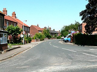
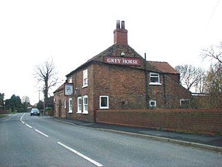
Whitley is a village in North Yorkshire, England, close to the Aire and Calder Navigation and the M62 motorway. The population of the village at the 2001 census was recorded as being 574, which had risen to 1,021 by the time of the 2011 census. In 2015, North Yorkshire County Council estimated the population to have risen again to 1,110. It was historically part of the West Riding of Yorkshire until 1974. From 1974 to April 2023 it was in the Selby District of North Yorkshire.

<span class="mw-page-title-main">Osgodby, Barlby with Osgodby</span> Village and civil parish in North Yorkshire, England

Osgodby is a village in the civil parish of Barlby with Osgodby, in North Yorkshire, England, 2 miles (3.2 km) from Selby.

<span class="mw-page-title-main">Naburn</span> Village and civil parish in North Yorkshire, England

Naburn is a small village and civil parish in the unitary authority of the City of York in the ceremonial county of North Yorkshire, England. It lies on the eastern side of the River Ouse about 4 miles (6.4 km) south of York. According to the 2001 census the parish had a population of 470, increasing to 516 at the 2011 census.

<span class="mw-page-title-main">Staincross Wapentake</span> Former division of the West Riding of Yorkshire, England

Staincross was a Wapentake (Hundred), which is an administrative division, in the historic county of the West Riding of Yorkshire. It consisted of seven parishes, and included the towns of Barnsley and Penistone

<span class="mw-page-title-main">Buttercrambe</span> Village in North Yorkshire, England

Buttercrambe is a small village in the Buttercrambe with Bossall civil parish, in North Yorkshire, England. Buttercrambe is some 9 miles (14 km) north-east of York, and on average about 56 feet (17 m) above sea level. The settlement is mentioned in the Domesday Book, and the name derives from the Old English of butere and crambe. Crambe is a word meaning bend, and so Buttercrambe's literal translation is rich piece of land in the bend of the river (Derwent).

<span class="mw-page-title-main">Hemingbrough</span> Village and civil parish in North Yorkshire, England

Hemingbrough is a small village and civil parish in North Yorkshire, England that is located approximately 5 miles (8 km) from Selby and 4 miles (6.4 km) from Howden on the A63. It was in the historic East Riding of Yorkshire, but since 1974 has come under North Yorkshire. The village has a 12th-century former collegiate church, a Methodist chapel and shops. The village also has a primary school and nursery as well as a playing field for the local children. The surrounding area makes up part of the Humberhead Levels and is flat land mainly used for mixed agriculture. It is thought that from this village came Walter of Hemingbrough, one of Britain's early chroniclers. Writing in the 14th century, he gave us a history beginning with the Norman conquest, now in the British Museum.

<span class="mw-page-title-main">North Duffield</span> Village and civil parish in North Yorkshire, England

North Duffield is a village and civil parish in the Selby District of North Yorkshire, England. It was historically part of the East Riding of Yorkshire until 1974. It lies about 4 miles (7 km) north-east of Selby and 11 miles (18 km) south-east of York, on the A163 road from Selby to Market Weighton. The River Derwent forms the eastern boundary of the parish. It has an area of around 10,080 acres (4,081 ha). There are approximately 1,800 residents in the village, the majority of whom are aged between 30 and 50 years. The population at the 2011 Census was 1,317.

<span class="mw-page-title-main">North Stainley</span> Village and civil parish in North Yorkshire, England

North Stainley is a village in the Harrogate district of North Yorkshire, England 4 miles (6.4 km) north of Ripon. Historically part of the West Riding of Yorkshire, it is the closest settlement to the theme park Lightwater Valley which is 0.62 miles (1 km) to the south.

<span class="mw-page-title-main">North Otterington</span> Village and civil parish in North Yorkshire, England

North Otterington is a civil parish with no village centre on the east bank of the River Wiske, in the Hambleton District of North Yorkshire, England. North Yorkshire County Council estimated its population in 2011 to be 40 and 30 in 2015. Details are also included in the civil parish of Ainderby Steeple. It is on the A167 road 3 miles (4.8 km) south of Northallerton; South Otterington is further south on the same road.

<span class="mw-page-title-main">Moor Monkton</span> Village and civil parish in North Yorkshire, England

Moor Monkton is a village and civil parish in the former Harrogate District of North Yorkshire, England. It is situated on the River Nidd and 7 miles (11 km) north-west from York city centre.

<span class="mw-page-title-main">Stillingfleet</span> Village and civil parish in North Yorkshire, England

Stillingfleet is a village and civil parish in North Yorkshire, England. It was in the historic East Riding of Yorkshire, but since 1974 has come under North Yorkshire. It is about 6 miles (10 km) south of York and nearby settlements include Acaster Selby, Naburn and Appleton Roebuck.

<span class="mw-page-title-main">Cliffe, Selby</span> Village and civil parish in North Yorkshire, England

Cliffe is a small village and civil parish in North Yorkshire, England. It was historically part of the East Riding of Yorkshire until 1974, but from 1974 to 2023 was in the Selby District of the shire county of North Yorkshire. In 2023 the district was abolished and North Yorkshire became a unitary authority.

<span class="mw-page-title-main">Skipwith</span> Village and civil parish in North Yorkshire, England

Skipwith is a village and civil parish about 4 miles (6.4 km) north-east of Selby and 10 miles (16 km) south-east of York in North Yorkshire, England. It was historically in the East Riding of Yorkshire. After the 1974 local government reorganisation Skipwith was in the Selby District of the shire county of North Yorkshire. In 2023 the district was abolished and North Yorkshire became a unitary authority.

<span class="mw-page-title-main">Kelfield, North Yorkshire</span> Village and civil parish in North Yorkshire, England

Kelfield is a small village and civil parish in the Selby district of North Yorkshire, England. It was historically part of the East Riding of Yorkshire until 1974.

<span class="mw-page-title-main">Flasby</span> Hamlet in North Yorkshire, England

Flasby is a hamlet in the Yorkshire Dales in North Yorkshire, England. It is one of the two settlements, with Winterburn, in the civil parish of Flasby with Winterburn, part of the Craven district. The population of the civil parish was estimated at 80 in 2012, measured at 207 in the 2011 Census.

<span class="mw-page-title-main">St Helen's Church, Thorganby</span>

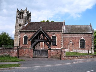
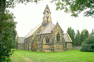
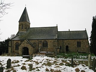
St Helen's Church is the parish church of Thorganby, a village in the Selby district of North Yorkshire, in England.

References

  1. 1 2 UK Census (2011). "Local Area Report – Thorganby Parish (E04007775)". Nomis. Office for National Statistics . Retrieved 30 November 2019.
  2. "History of Thorganby, in Selby and East Riding | Map and description". www.visionofbritain.org.uk. Retrieved 25 November 2020.
  3. "Thorganby | Domesday Book". opendomesday.org. Retrieved 29 March 2020.
  4. Ekwall, Eilert (1960). The concise Oxford dictionary of English place-names (4 ed.). Oxford: Oxford University Press. p. 466. ISBN   0-19-869103-3.
  5. "Thorganby | British History Online". www.british-history.ac.uk. Retrieved 29 March 2020.
  6. Historic England. "Church of St Helen (Grade I) (1148469)". National Heritage List for England . Retrieved 29 March 2020.
  7. "Church of St Helen". www.achurchnearyou.com. Retrieved 29 March 2020.
  8. "History of Thorganby, in Selby and East Riding | Map and description". www.visionofbritain.org.uk. Retrieved 29 March 2020.
  9. "Thorganby, North Yorkshire, England - Borthwick Catalogue". borthcat.york.ac.uk. Retrieved 29 March 2020.
  10. "Ouse and Derwent Wapentake | British History Online". www.british-history.ac.uk. Retrieved 29 March 2020.
  11. "290" (Map). York. 1:25,000. Explorer. Ordnance Survey. 2015. ISBN   9780319244876.
  12. "Lower Derwent Valley | Yorkshire Wildlife Trust". www.ywt.org.uk. Retrieved 29 March 2020.
  13. "Genuki: THORGANBY: Geographical and Historical information from the year 1892., Yorkshire (East Riding)". www.genuki.org.uk. Retrieved 29 March 2020.
  14. Suggitt, Gordon (2007). Lost railways of North and East Yorkshire. Newbury: Countryside Books. p. 127. ISBN   978-1-85306-918-5.
  15. Young, Alan (2015). Lost Stations of Yorkshire; the North and East Ridings. Kettering: Silver Link. p. 111. ISBN   978-1-85794-453-2.
  16. UK Census (2001). "Local Area Report – Thorganby Parish (36UH078)". Nomis. Office for National Statistics . Retrieved 29 March 2020.
  17. "2015 Population Estimates Parishes" (PDF). northyorks.gov.uk. December 2016. p. 18. Archived from the original (PDF) on 4 June 2022. Retrieved 29 March 2020.
  18. "Film star Robert Redford in Thorganby village pub". BBC News. 17 March 2011. Retrieved 2 July 2020.