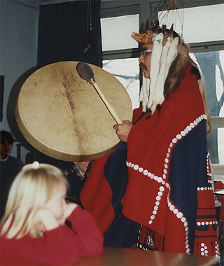
The Tsimshian are an Indigenous people of the Pacific Northwest Coast of North America. Their communities are mostly in coastal British Columbia in Terrace and Prince Rupert, and Metlakatla, Alaska on Annette Island, the only reservation in Alaska.
Terrace is a city in the Skeena region of west central British Columbia, Canada. This regional hub lies east of the confluence of the Kitsumkalum River into the Skeena River. On BC Highway 16, junctions branch northward for the Nisga'a Highway to the west and southward for the Stewart–Cassiar Highway to the east. The locality is by road about 204 kilometres (127 mi) southwest of Smithers and 144 kilometres (89 mi) east of Prince Rupert. Transportation links are the Northwest Regional Airport, a passenger train, and bus services.

The Stewart–Cassiar Highway, also known as the Dease Lake Highway and the Stikine Highway as well as the Thornhill –Kitimat Highway from Kitimat to Thornhill, is the northwesternmost highway in the Canadian province of British Columbia. A scenic route through some of the province's most isolated areas, the highway first gained designation as British Columbia Highway 37 in the year 1975. At that time, its southern terminus was at the community of New Hazelton on the BC Highway 16. In 1975, with the completion of a new bridge over the Kitimat River, the highway's Yellowhead junction was relocated to a point on Highway 16 just south of the site of Kitwanga. Highway 37 was then extended south to Kitimat in 1986 superseding what was then designated Highway 25. At the north end, the highway briefly stretches into the Yukon, becoming Yukon Highway 37.

The Skeena River is the second-longest river entirely within British Columbia, Canada. Since ancient times, the Skeena has been an important transportation artery, particularly for the Tsimshian and the Gitxsan—whose names mean "inside the River of Mist" ,and "people of the River of Mist," respectively. The river and its basin sustain a wide variety of fish, wildlife, and vegetation, and communities native to the area depend on the health of the river. The Tsimshian migrated to the Lower Skeena River, and the Gitxsan occupy territory of the Upper Skeena.

North Coast-Haida Gwaii is a provincial electoral district for the Legislative Assembly of British Columbia, Canada. It was created by 1990 legislation which came into effect for the 1991 election, largely out of the previous riding of Prince Rupert.

Skeena is a provincial electoral district for the Legislative Assembly of British Columbia, Canada. It first appeared in the provincial election of 1924. It should not be confused with the former federal electoral district of Skeena, which encompassed a larger area.

Kitimat is a district municipality in the North Coast region of British Columbia, Canada. It is a member municipality of the Regional District of Kitimat–Stikine regional government. The Kitimat Valley is part of the most populous urban district in northwest British Columbia, which includes Terrace to the north along the Skeena River Valley. The city was planned and built by the Aluminum Company of Canada (Alcan) during the 1950s. Its post office was approved on 6 June 1952.
Iskut is a small, mostly Indigenous community in the Stikine Country of northwestern British Columbia. It is located on Highway 37, at the north end of Eddontenajon Lake just south of Dease Lake and the crossing of the Stikine River.

The Regional District of Kitimat–Stikine is a local government administration in northwestern British Columbia, Canada. As of the 2016 Canadian census, it had a population of 37,367 living on a land area of 104,464.61 square kilometres (40,334.01 sq mi). Its administrative offices are in the city of Terrace. The next-largest municipality in the regional district is the District Municipality of Kitimat. The other incorporated municipalities in the regional district are the Village of Hazelton, the District of New Hazelton and the District of Stewart. Unincorporated communities are many, most of them Indian Reserves which are not part of the governmental system of the regional district, which has limited powers relating mostly to municipal-type services. The remote settlement of Dease Lake, formerly in the Stikine Region, was added to the regional district on December 1, 2007. Thornhill is the largest unincorporated community in the regional District with a population of 5000+ residents.

CityWest Cable and Telephone Corporation, operating as CityWest, is a municipally-owned telecommunications holding company which provides telephone, cable television, and internet services in Prince Rupert, British Columbia, Canada and the surrounding regions. CityWest also purchased Monarch Cablesystems' assets, which were split between the former CityTel and Shaw Communications.
Kitselas, Kitsalas or Gits'ilaasü are one of the 14 tribes of the Tsimshian nation of British Columbia, in northwestern Canada. The original name Gits'ilaasü means "people of the canyon." The tribe is situated at Kitselas, British Columbia, at the upper end of Kitselas Canyon, which is on the Skeena River. It was once a great trading nexus, just outside and upriver from the city of Terrace. It is the most upriver of the 14 tribes and it borders the territory of the Gitxsan nation.

Port Essington was a cannery town on the south bank of the Skeena River estuary in northwestern British Columbia, Canada, between Prince Rupert and Terrace, and at the confluence of the Skeena and Ecstall Rivers. It was founded in 1871 by Robert Cunningham and Thomas Hankin and was for a time the largest settlement in the region. During its heyday it was home to an ethnic mix of European-Canadians, Japanese-Canadians, and members of First Nations from throughout the region, especially Tsimshians from the Kitselas and Kitsumkalum tribes. In the Tsimshian language, the site of Port Essington is called Spaksuut or, in English spelling, "Spokeshute", which means "autumn camping place". This also became the Tsimshian name for the town of Port Essington, and was conferred on Spokeshute Mountain, which stands above and behind the community. It sits on the traditional territory of the Gitzaxłaał tribe, one of the nine Tsimshian tribes based at Lax Kw'alaams. In 1888, the anthropologist Franz Boas visited Port Essington, interviewing Haida and Tsimshian individuals and establishing a working relationship with Odille Morison, the Tsimshian linguist, who lived in Port Essington.
Walter George Wright was a Canadian hereditary chief of the Tsimshian from the community of Kitselas, near Terrace, British Columbia, whose extensive knowledge of oral history was published posthumously in book form as Men of Medeek.

The British Columbia Interior, popularly referred to as the BC Interior or simply the Interior, is a geographic region of the Canadian province of British Columbia. While the exact boundaries are variously defined, the British Columbia Interior is generally defined to include the 14 regional districts that do not have coastline along the Pacific Ocean or Salish Sea, and are not part of the Lower Mainland. Other boundaries may exclude parts of or even entire regional districts, or expand the definition to include the regional districts of Fraser Valley, Squamish–Lillooet, and Kitimat–Stikine.
The District of Port Edward is a district municipality of approximately 577, located in the Range 5 Coast Land District of British Columbia, Canada. It is situated on the Tsimpsean Peninsula, at Porpoise Harbour, near the southern end of Chatham Sound, close to the mouth of the Skeena River, 15 km (9 mi) southeast of Prince Rupert.

The Skeena River is British Columbia's fastest flowing waterway, often rising as much as 17 feet (5.2 m) in a day and fluctuating as much as sixty feet between high and low water. For the steamboat captains, that wide range made it one of the toughest navigable rivers in British Columbia. Nevertheless, at least sixteen paddlewheel steamboats plied the Skeena River from the coast to Hazelton from 1864 to 1912.
Kitselas is a railway point on the northwestern shore of the Skeena River in the Skeena region of west central British Columbia, Canada. The former name was Vanarsdol. Across the Skeena to the southwest is the mouth of the Zymoetz River. This river bridge on BC Highway 16 is by road about 10 kilometres (6 mi) northeast of Terrace.
The Klappan Coalbed Methane Project is a gas project owned by Shell Canada that looks to develop the coalbed methane from an area in northern British Columbia, near the source of three rivers: the Skeena River, Nass River, and Stikine River, and also the namesake Klappan River. The area is known in environmental politics and native lore as the Sacred Headwaters or Kablona. The project is the source of controversy and is opposed by First Nations groups and non-governmental organizations. If developed, the project will include a network of gas wells connected by roads and pipelines, as well as a pipeline to deliver the gas to market.
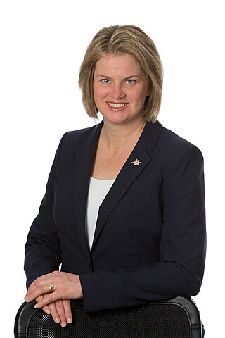
Jennifer Rice is a Canadian politician, who was elected to the Legislative Assembly of British Columbia to represent the electoral district of North Coast. She is a member of the BC New Democratic Party. Rice was first elected as a member of legislative assembly (MLA) in the 2013 provincial election and was re-elected in the 2017 election. In the 40th Parliament of British Columbia she acted as the official opposition's critic for northern and rural economic development and deputy critic for children and family development and introduced one private member bill, the Drinking Water Protection Amendment Act regarding regularizing testing of drinking water in schools.
The Ecstall River is a tributary of the Skeena River in the province of British Columbia, Canada. It originates in the Kitimat Ranges, and flows about 110 km (68 mi) to the lower tidal reach of the Skeena River at Port Essington, about 30 km (19 mi) southeast of Prince Rupert, 95 km (59 mi) southwest of Terrace, and 85 km (53 mi) northwest of Kitimat. Its drainage basin covers about 1,485 km2 (573 sq mi) and contains the largest blocks of unlogged land on the north coast of British Columbia, although large-scale industrial logging operations, both active and proposed, have been occurring in the watershed since the 1980s.

