
Rothwell is a market town in the south-east of the City of Leeds metropolitan borough in West Yorkshire, England. It is situated between Leeds and Wakefield.

Morley is a market town and a civil parish within the City of Leeds metropolitan borough, in West Yorkshire, England.

Austhorpe is a civil parish and residential suburb of east Leeds, West Yorkshire, England. It is 5 miles (8.0 km) to the east of city centre and close to the A6120 dual carriageway and the M1 motorway.

Middleton is a largely residential suburb of Leeds in West Yorkshire, England and historically a village in the West Riding of Yorkshire. It is situated on a hill 4 miles (6 km) south of Leeds city centre and 165 miles (266 km) north north-west of London.

Tingley is a settlement in West Yorkshire, Northern England, forming part of the parish of West Ardsley and of the City of Leeds metropolitan borough.

East Ardsley is a village in the City of Leeds metropolitan borough, in West Yorkshire, England.

Compton Dundon is a village and civil parish in Somerset, England, lying beside King's Sedgemoor and the Polden Hills, 5 miles (8 km) south of Glastonbury and 4 miles (6 km) north of Somerton in the South Somerset district. The village has a population of 705. The parish includes the small village of Dundon and the hamlet of Littleton.

Morley and Outwood is a constituency represented in the House of Commons of the UK Parliament since 2015 by Andrea Jenkyns of the Conservative Party.

Drighlington is a village and civil parish in the City of Leeds metropolitan district, West Yorkshire, England. Historically part of the West Riding of Yorkshire, the village lies 5 miles (9 km) south-west of Leeds and 4 miles (6 km) south-east of Bradford. The name of the village is often shortened to Drig. The population of the civil parish as of the 2011 census was 5,528.
Swillington is a village and civil parish near Leeds, West Yorkshire, England, in the City of Leeds metropolitan borough. It is situated 5 miles (8 km) east from Leeds city centre, north of the River Aire, and is surrounded by streams including Fleakingley Beck. In 2001, Swillington had a population of about 3,530, reducing to 3,381 at the 2011 Census.

West Ardsley is commonly used to refer to an area on the south-west edge of the City of Leeds metropolitan borough, possessing a WF postcode in the WF3 (Wakefield) postcode area while the village telephone numbers are "0113", the Leeds prefix. Historically part of the West Riding of Yorkshire, it roughly approximates to an amalgamation of Tingley, Woodkirk, Hill Top, Upper Green, Common Side, Beggarington Hill and a number of other hamlets. The parish church is at Woodkirk. Being in the middle of several towns, West Ardsley has become a dormitory settlement.
Lofthouse is a village between the cities of Wakefield and Leeds in West Yorkshire, England. The village falls within the Ardsley and Robin Hood ward of the City of Leeds Council. It is in the City of Leeds metropolitan borough but with a Wakefield postal address (WF3). It is mentioned as Locthuse, also as Loftose in the 1086 Domesday Book.
Shadwell is a village and civil parish in north-east Leeds, West Yorkshire, England. The village is 6 miles (9.7 km) to the north east of Leeds city centre.
Robin Hood is a village in West Yorkshire, England, within the City of Leeds metropolitan borough, with Wakefield WF3, and Leeds LS26 postcodes. It is situated on the A61 and A654 between Leeds and Wakefield, close to Rothwell and Lofthouse.

Potterton is a hamlet 1 mile (1.5 km) north of Barwick-in-Elmet in City of Leeds, West Yorkshire, England. The hamlet falls within the Harewood ward of the Leeds Metropolitan Council. The hamlet is just south of the A64 road and so has access to junction 44 of the A1(M) motorway 2.5 miles (4 km) away with Leeds being only 7 miles (11 km) to the west.

Ardsley and Robin Hood is an electoral ward of Leeds City Council in the south of Leeds, West Yorkshire, covering suburb areas and villages including Robin Hood, Tingley as well as both West and East Ardsley.
The East and West Yorkshire Union Railway was promoted in 1883 to connect the Hull and Barnsley Railway at Drax with Leeds. The company was unable to raise the money it needed to build the line, and it substantially reduced its scope to connecting collieries around Rothwell with the existing main line network nearby. This was successful, with trains running from 1890, but the company decided it would find a way to connect to Leeds and operate a much truncated passenger service, from Rothwell. It sponsored the South Leeds Junction Railway to make a connection from Rothwell to the Midland Railway at Stourton; the SLJR was soon re-absorbed by the E&WYUR. The passenger service started on 4 January 1904 but it was a disastrous failure, and it was soon withdrawn from 1 October 1904.
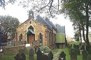
Ardsley and Robin Hood is a ward in the metropolitan borough of the City of Leeds, West Yorkshire, England. It contains 16 listed buildings that are recorded in the National Heritage List for England. Of these, three are listed at Grade II*, the middle of the three grades, and the others are at Grade II, the lowest grade. The ward contains the settlements of East Ardsley, Lofthouse, Robin Hood, Thorpe on the Hill, and West Ardsley, and the surrounding area. Most of the listed buildings are houses and cottages, farm houses and farm buildings, and the others are a church, memorials in the churchyard, and a former textile mill.


