Tidal River, Victoria

Last updated

Tidal River
Victoria
Tidal River, Wilsons Promontory - Mar 2012.jpg
Tidal River and the camp ground looking south
Australia Victoria South Gippsland Shire location map.svg
Red pog.svg
Tidal River
Location in South Gippsland Shire
Coordinates 39°01′50″S146°19′17″E / 39.03056°S 146.32139°E / -39.03056; 146.32139 Coordinates: 39°01′50″S146°19′17″E / 39.03056°S 146.32139°E / -39.03056; 146.32139
Postcode(s) 3959
Elevation5 m (16 ft)
Location
LGA(s) South Gippsland Shire
State electorate(s) Gippsland South
Federal Division(s) Monash

Tidal River is a locality in Wilsons Promontory National Park, Wilsons Promontory, Victoria, Australia. It contains the main park administration and service centres as well as a permanent camping ground that takes its name from the Tidal River, which flows past the camping ground to the north.

Wilsons Promontory National Park Protected area in Victoria, Australia

The Wilsons Promontory National Park, commonly known as Wilsons Prom or The Prom, is a national park in the Gippsland region of Victoria, Australia, located approximately 157 kilometres (98 mi) southeast of Melbourne.

Victoria (Australia) State in Australia

Victoria is a state in south-eastern Australia. Victoria is Australia's smallest mainland state and its second-most populous state overall, making it the most densely populated state overall. Most of its population lives concentrated in the area surrounding Port Phillip Bay, which includes the metropolitan area of its state capital and largest city, Melbourne, Australia's second-largest city. Victoria is bordered by Bass Strait and Tasmania to the south, New South Wales to the north, the Tasman Sea, to the east, and South Australia to the west.

Australia Country in Oceania

Australia, officially the Commonwealth of Australia, is a sovereign country comprising the mainland of the Australian continent, the island of Tasmania, and numerous smaller islands. It is the largest country in Oceania and the world's sixth-largest country by total area. The neighbouring countries are Papua New Guinea, Indonesia, and East Timor to the north; the Solomon Islands and Vanuatu to the north-east; and New Zealand to the south-east. The population of 25 million is highly urbanised and heavily concentrated on the eastern seaboard. Australia's capital is Canberra, and its largest city is Sydney. The country's other major metropolitan areas are Melbourne, Brisbane, Perth, and Adelaide.

Contents

History

Tidal River was originally established as an army commando training base during World War Two, operating from 1940 to 1942. [1] At the end of the war, the previous National Park ranger station, chalet and camping area at Darby River was in such poor condition that it was not returned to use, but instead, remaining army buildings at Tidal River were adapted and reused for staff and visitor accommodation. In about 1950 the former Darby River ranger's cottage was relocated to Tidal River, leaving the Tidal River and Wilsons Promontory Lighthouse the only permanently inhabited parts of the park. [2]

Darby River, Victoria Town in Victoria, Australia

Darby River is a locality in Gippsland in southeastern Victoria, Australia. Located within Wilson's Promontory National Park, it was the location of the original park entrance, ranger station and accommodation centre from 1909 until the Second World War. Often referred to just as The Darby, it was the location of the National Park Committee of Management Rooms from about 1909, a Ranger's cottage from 1913, and the 'Chalet' for tourist accommodation from 1923. The Chalet began as a small 6 room building and expanded to more than 24 accommodation rooms, kitchen, dining hall, bathrooms and the like. During World War Two the area was the site of the Headquarters Camp of the No 7 Commando Training Centre. At this time large numbers of huts and tents were erected and the Chalet was taken over for the Officers Mess. Following the war most of the buildings were removed or fell into disrepair and were demolished. The Ranger's House was moved to Tidal River.

Wilsons Promontory Lighthouse lighthouse in Victoria, Australia

Wilsons Promontory Lighthouse is situated on South East Point, Wilsons Promontory, Victoria, Australia. From its point on the peninsula, it commands almost 360° views of Bass Strait. The Wilson's Promontory lighthouse is the southernmost lighthouse on mainland Australia, and is approximately 18 kilometres (11 mi) from the nearest town, Tidal River. Dormitory-style accommodation is available in the lighthouse.

The campground and facilities

Tidal River is the main location for accommodation and camping in Wilsons Promontory National Park. Tidal River Campground has 484 camping and caravan sites (including 20 powered sites) situated near the beach and river. [3] There are also 11 remote walk-in sites located within the park.

Tidal River campground is nestled in sand dunes behind Norman Bay, on the western side of the peninsula. The only access road open to visitors leads from Yanakie at the park entrance to Tidal River, a distance of 32 km.

Yanakie, Victoria Town in Victoria, Australia

Yanakie is a small, coastal township and district on the Yanakie Isthmus in South Gippsland, in the state of Victoria, south-eastern Australia.

When fully occupied, the settlement of Tidal River swells to over 2,000 people. There is a visitor centre open daily, a general store with an extensive range of products, fish and chippery and café. The outdoor cinema, established in the late 1940s, is a nostalgic favourite amongst summer campers who will sometimes line up for over an hour before tickets can be bought so they can save a seat in the front row with a blanket. There is no service station or fuel available at the campsite.

During summer a ballot is held to allocate sites from Christmas until late January. Regardless of the time of year, all accommodation must be pre-booked. [3]

Related Research Articles

Uluṟu-Kata Tjuṯa National Park Protected area in the Northern Territory, Australia

Uluṟu-Kata Tjuṯa National Park is a protected area in the Northern Territory of Australia. The park is home to both Uluru and Kata Tjuta. It is located 1,943 kilometres (1,207 mi) south of Darwin by road and 440 kilometres (270 mi) south-west of Alice Springs along the Stuart and Lasseter Highways. The park covers 1,326 square kilometres (512 sq mi) and includes the features it is named after: Uluru and, 40 kilometres (25 mi) to its west, Kata Tjuta. The location is listed with UNESCO World Heritage sites for natural and cultural landscape.

Mount Rainier National Park national park of the United States

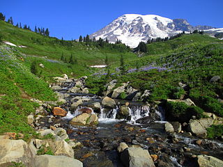
Mount Rainier National Park is an American national park located in southeast Pierce County and northeast Lewis County in Washington state. The park was established on March 2, 1899 as the fifth national park in the United States, preserving 236,381 acres including all of Mount Rainier, a 14,411-foot (4,392 m) stratovolcano. The mountain rises abruptly from the surrounding land with elevations in the park ranging from 1,600 feet to over 14,000 feet (490–4,300 m). The highest point in the Cascade Range, Mount Rainier is surrounded by valleys, waterfalls, subalpine meadows, and 91,000 acres of old-growth forest. More than 25 glaciers descend the flanks of the volcano, which is often shrouded in clouds that dump enormous amounts of rain and snow.

Tidal River (Victoria) perennial river of the West Gippsland catchment, located in the Wilsons Promontory region of the Australian state of Victoria

The Tidal River is a perennial river of the West Gippsland catchment, located in the Wilsons Promontory region of the Australian state of Victoria. A permanent camping ground, which flows past the camping ground to the north, is also called Tidal River.

South East Point

South East Point lies on the southerly tip of Wilsons Promontory, Victoria, Australia. South East Point is located at 39°07′S146°25′E. It commands sensational views of Bass Strait and is a major landmark for all ships travelling between the southern Australian ports and the Pacific Ocean. South East Point is the site of the Wilsons Promontory Lighthouse. The only access for visitors is a full day hike from the Tidal River camping ground.

William Orlando Darby American World War II Army colonel

William O. Darby was a career United States Army officer who fought in World War II, where he was killed in action in Italy. He was posthumously promoted to brigadier general. Darby led the famous Darby's Rangers, which evolved into the U.S. Army Rangers.

Campsite place used for overnight stay in the outdoors

A campsite or camping pitch is a place used for overnight stay in an outdoor area. In UK English, a campsite is an area, usually divided into a number of pitches, where people can camp overnight using tents or camper vans or caravans; this UK English use of the word is synonymous with the US English expression campground. In American English, the term campsite generally means an area where an individual, family, group, or military unit can pitch a tent or park a camper; a campground may contain many campsites.

Denali National Park and Preserve national park in Alaska

Denali National Park and Preserve is an American national park and preserve located in Interior Alaska, centered on Denali, the highest mountain in North America. The park and contiguous preserve encompass 6,045,153 acres which is larger than the state of New Hampshire. On December 2, 1980, 2,146,580-acre Denali Wilderness was established within the park. Denali's landscape is a mix of forest at the lowest elevations, including deciduous taiga, with tundra at middle elevations, and glaciers, snow, and bare rock at the highest elevations. The longest glacier is the Kahiltna Glacier. Wintertime activities include dog sledding, cross-country skiing, and snowmobiling. The park received 594,660 recreational visitors in 2018.

Mount Robson Provincial Park provincial park in British Columbia, Canada

Mount Robson Provincial Park is a vast provincial park in the Canadian Rockies with an area of 2,249 km². The park is located entirely within British Columbia, bordering Jasper National Park in Alberta. The B.C. legislature created the park in 1913, the same year as the first ascent of Mount Robson by a party led by Conrad Kain. It is the second oldest park in the provincial system. The park is named for Mount Robson, which has the highest point in the Canadian Rockies and is located entirely within the park.

Gilwell Park UK camp site and activity centre for Scouting and Guiding groups and other youth organizations

Gilwell Park is a camp site and activity centre for Scouting and Guiding groups, as well as schools and other youth organisations. The site also houses a training and conference centre, including the hosting of social events such as weddings and birthday parties. The 44 hectare (109 acre) site is in Sewardstonebury, Epping Forest, close to Chingford, London.

Mornington Peninsula peninsula and region of Victoria, Australia

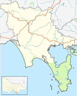
The Mornington Peninsula is a peninsula located south-east of Melbourne, Victoria, Australia. It is surrounded by Port Phillip to the west, Western Port to the east and Bass Strait to the south, and is connected to the mainland in the north. Geographically, the peninsula begins its protrusion from the mainland in the area between Pearcedale and an area south of Frankston. The area was originally home to the Mayone-bulluk and Boonwurrung-Balluk clans and formed part of the Boonwurrung nation's territory prior to European settlement.

Mount Arapiles-Tooan State Park Protected area in Victoria, Australia

The Mount Arapiles-Tooan State Park is a state park in the Wimmera plains of western Victoria, Australia. It encompasses Mount Arapiles, Mitre Rock, and the Tooan block. The park covers an area of 7,475 hectares and is valuable for nature conservation, with approximately 14% of the State's flora species represented in the Mount Arapiles area.

Wilgus State Park state park in Vermont, United States

Wilgus State Park is a state park in Ascutney, Vermont. The park offers canoeing along the Connecticut River and hiking up the Pinnacle Trail. The park has tent and lean-to sites and is quite close to Mount Ascutney and the Saint-Gaudens National Historic Site. The park was originally constructed by the Civilian Conservation Corps (CCC) and is now administered by the Vermont Department of Forests, Parks, and Recreation as part of the Vermont state park system. It is named after William J. Wilgus, who donated the land for the park in 1933. The park is listed on the National Register of Historic Places for its well-preserved CCC infrastructure.

Wilsons Promontory Marine National Park Protected area in Victoria, Australia

The Wilsons Promontory Marine National Park is a protected marine national park located in the South Gippsland region of Victoria, Australia. The 15,500-hectare (38,000-acre) marine park is situated off the southern tip of Wilsons Promontory and extends along the coastline from Norman Bay, near Tidal River, in the west around the southern tip of the promontory to Cape Wellington in the east. It extends offshore to the Glennie and Anser groups of offshore islands.

Lake Catani lake in Australia

Lake Catani is an artificial lake in the Mount Buffalo National Park in Victoria, Australia. It was constructed in 1910 under the supervision and probably design of the Victorian Public Works engineer, Carlo Catani, to provide recreational facilities in the newly opened winter resort.

Cotton Tree Caravan Park

Cotton Tree Caravan Park is a heritage-listed caravan park at Cotton Tree Parade, Cotton Tree, Sunshine Coast Region, Queensland, Australia. It was added to the Queensland Heritage Register on 3 April 2009.

References

  1. No. 7 Infantry Training Centre For Commandos
  2. Garnet, J. Roslyn, (with additional chapters by Terry Synan and Daniel Catrice) A History of Wilsons Promontory, Published by the Victorian National Parks Association
  3. 1 2 "Parks Victoria - Tidal River campground". parkweb.vic.gov.au. Retrieved 20 June 2015.