Electoral district of Gippsland South

Last updated

Gippsland South
VictoriaLegislative Assembly
Electoral district of Gippsland South (Victoria) 2022.svg
Location of Gippsland South (dark green) in Victoria
State Victoria
Created1859
MP Danny O'Brien
Party National
Namesake South Gippsland
Electors 42,564 (2018)
Area8,232 km2 (3,178.4 sq mi)
DemographicRural
Electorates around Gippsland South:
Narracan Narracan
Morwell
Gippsland East
Bass Gippsland South Tasman Sea
Bass Strait Bass Strait Bass Strait

The electoral district of Gippsland South (initially known as South Gippsland) [1] is a Lower House electoral district of the Victorian Parliament. [2] It is located within the Eastern Victoria Region of the Legislative Council.

Contents

Gippsland South extends along the state's coast from Venus Bay to Loch Sport [3] and includes the country Victorian towns of Foster, Korumburra, Leongatha, Mirboo North, Port Albert, Port Welshpool, Rosedale, Sale and Yarram. The electorate includes all of South Gippsland Shire and the southern parts of Wellington Shire. [3] Industries include agriculture, timber production and tourism. Dairying is the biggest agricultural contributor to the local economy. [4] Wilsons Promontory National Park, Corner Inlet, and numerous lakes and islands along the coast and border are examples of natural features.

Its area was initially defined by the 1858 Electoral Act as: "Commencing at the mouth of Merryman's Creek [a] on the Ninety Mile Beach; bounded on the north by Merryman's Creek to where the road from Tarraville to Rosedale crosses said creek near Bayless's pre-emptive right, thence by a line west fourteen degrees to Buneep; on the west by the counties of Evelyn and Mornington to Cape Patterson; and on the south and south-east by the sea-coast to the commencing point" [5]

The Electoral Act Amendment Act of 1888 created new districts of Gippsland Central, Gippsland East and Gippsland West and reduced the size of Gippsland South (renaming it from South Gippsland) and Gippsland North. [6]

It has never been won by the Labor Party, and has been in the hands of the National Party for all but two terms since 1929.

Sir Herbert Hyland held the seat for thirty years from 1929 until he died in office in 1970. He held many portfolios in government including Transport, Chief Secretary, State Development, Labour, Decentralisation and Transport and Prices. Hyland was knighted in 1952,[6] and elected leader of the parliamentary Country Party in 1955.

The district is currently held by Nationals MP Danny O'Brien, who won the seat in a by-election in 2015 following the resignation of former Nationals leader Peter Ryan.

a = now known as Merriman Creek

Members for Gippsland South

MemberPartyTerm
  Angus McMillan Unaligned 1859–1860
  George Hedley Unaligned 1861–1862
  John Johnson Unaligned 1862–1864
  Peter Snodgrass Unaligned 1864–1867
  Thomas McCombie Unaligned 1868–1869
  George Macartney Unaligned 1869–1871
  Francis Mason Unaligned 1871–1877
  George Macartney Unaligned 1877–1878
  Francis Mason Unaligned 1878–1886
  Arthur Groom Unaligned 1886–1889
  Francis Mason Unaligned 1889–1902
  Thomas Livingston Ministerialist 1902–1922
  Commonwealth Liberal
  Nationalist
  Walter West Nationalist 1922–1927
  Henry Bodman Independent 1927–1927
  Walter West Nationalist 1927–1929
 Sir Herbert Hyland Country 1929–1970
  James Taylor Liberal 1970–1973
  Neil McInnes National 1973–1982
  Liberal
  Tom Wallace National 1982–1992
  Peter Ryan National 1992–2015
  Danny O'Brien National 2015–present

Election results

2022 Victorian state election: Gippsland South [7] [8] [9]
PartyCandidateVotes%±%
National Danny O'Brien 22,56653.3−5.3
Labor Denise Ryan9,92023.4−4.8
Greens Jay Tiziani-Simpson3,5388.3−0.9
Independent Clay Esler2,4145.7+5.7
Freedom Angela Newnham1,3573.2+3.2
Animal Justice Helen Jeges1,3503.2+3.2
Family First Paul Furlong1,2182.9+2.9
Total formal votes42,36394.7+0.4
Informal votes2,3545.3−0.4
Turnout 44,71790.0+0.7
Two-party-preferred result
National Danny O'Brien 27,64565.2+1.2
Labor Denise Ryan14,72334.8−1.2
National hold Swing +1.2

Historical maps

Related Research Articles

<span class="mw-page-title-main">Electoral district of Benambra</span> State electoral district of Victoria, Australia

The electoral district of Benambra is one of the electoral districts of Victoria, Australia, for the Victorian Legislative Assembly. It covers an area of 10,037 square kilometres (3,875 sq mi) in north-eastern Victoria. The largest settlement is the city of Wodonga. Benambra also includes the towns of Baranduda, Barnawartha, Beechworth, Chiltern, Corryong, Eskdale, Kiewa, Mitta Mitta, Mount Beauty, Rutherglen, Tallangatta, Tangambalanga, Tawonga, Wahgunyah, and Yackandandah. It lies in the Northern Victoria Region of the upper house, the Legislative Council.

<span class="mw-page-title-main">Electoral district of Bass</span> State electoral district of Victoria, Australia

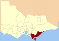
The electoral district of Bass is one of the electoral districts of Victoria, Australia, for the Victorian Legislative Assembly. It covers an area of 1,358 square kilometres (524 sq mi) south east of Melbourne, stretching from the satellite suburb of Clyde through rural areas to the coast at Inverloch and Phillip Island. It includes the suburbs and towns of Bass, Cape Paterson, Clyde, Corinella, Cowes, Grantville, Inverloch, Kilcunda, Koo Wee Rup, Lang Lang, Pearcedale, Rhyll, San Remo, Tooradin, Ventnor and Wonthaggi. It lies within the Eastern Victoria Region of the upper house, the Legislative Council.

<span class="mw-page-title-main">Electoral district of Gippsland East</span> State electoral district of Victoria, Australia

The electoral district of Gippsland East is an electoral district of the Victorian Legislative Assembly. It covers most of eastern Victoria and includes the towns of Bairnsdale, Lakes Entrance, Orbost, Omeo, Maffra and Heyfield. Gippsland East is the state's third largest electorate in area and covers 27,544 square kilometres.

<span class="mw-page-title-main">Electoral district of Narracan</span> State electoral district of Victoria, Australia

The electoral district of Narracan is an electoral district of the Victorian Legislative Assembly in Australia. It was first proclaimed in 1967 and has usually been held by the Liberal Party.

<span class="mw-page-title-main">Electoral district of Warrandyte</span> State electoral district of Victoria, Australia

The electoral district of Warrandyte is an Australian electoral district of the Victorian Legislative Assembly. It is an outer metropolitan electorate and contains the suburbs of Park Orchards, Ringwood North, Warrandyte, Warrandyte North, Warrandyte South, Warranwood, Wonga Park, most of Donvale, and parts of Chirnside Park, Doncaster East, and Ringwood.

<span class="mw-page-title-main">Electoral district of Morwell</span> State electoral district of Victoria, Australia

The electoral district of Morwell is an electoral district of the Victorian Legislative Assembly. It covers the regional centres of Moe, Morwell and Traralgon, as well as the surrounding rural areas in the middle of Gippsland.

<span class="mw-page-title-main">Electoral district of Brighton</span> State electoral district of Victoria, Australia

The electoral district of Brighton is an electoral district of the Victorian Legislative Assembly. It covers an area of 20 square kilometres (7.7 sq mi) in south-eastern Melbourne, including the suburbs of Brighton and Elwood, and parts of Brighton East and Hampton. It lies within the Southern Metropolitan Region of the upper house, the Legislative Council.

<span class="mw-page-title-main">Electoral district of Melbourne</span> State electoral district of Victoria, Australia

The electoral district of Melbourne is an electorate of the Victorian Legislative Assembly. It currently includes the localities of Docklands, Carlton, Melbourne, East Melbourne, West Melbourne, North Melbourne, Parkville, Newmarket, Kensington and Flemington, and includes Melbourne University. The district has been in existence since 1856.

<span class="mw-page-title-main">Electoral district of Lowan</span>

The electoral district of Lowan is a rural Victorian Legislative Assembly electoral district of the Victorian Parliament. It is located within the Western Victoria Region of the Legislative Council. It was initially created by the Electoral Act Amendment Act 1888, taking effect at the 1889 elections. It is the state’s biggest electorate by area, covering about 41,858 km².

<span class="mw-page-title-main">Electoral district of Shepparton</span> State electoral district of Victoria, Australia

The electoral district of Shepparton is a rural Lower House electoral district of the Victorian Parliament. It is located within the Northern Victoria Region of the Legislative Council.

<span class="mw-page-title-main">Electoral district of Colac</span>

The Electoral district of Colac was an electoral district of the Victorian Legislative Assembly, one of the inaugural districts of the first Assembly in 1856.

The electoral district of Gippsland West was an electoral district of the Legislative Assembly in the Australian state of Victoria. It was created by the Electoral Act Amendment Act 1888 along with Gippsland Central and Gippsland East. Gippsland North and Gippsland South were resized at the same time. The electorate was dissolved in 2002.

<span class="mw-page-title-main">Electoral district of Alberton</span> Former colonial electoral district of Victoria, Australia

The Electoral district of Alberton was an electoral district of the Legislative Assembly in the Australian colony of Victoria, located in the south-east of the then-colony.

<span class="mw-page-title-main">Electoral district of Maryborough (Victoria)</span> Former electoral district in Victoria, Australia

The Electoral district of Maryborough was an electorate of the Victorian Legislative Assembly based on an area around Maryborough, Victoria. It was created in the expansion of the Assembly by the Victorian Electoral Act, 1858, which took effect at the election in 1859.

Gippsland Province was an electorate of the Victorian Legislative Council from November 1882 until 2006. It was based in the Gippsland region of Victoria, Australia.

<span class="mw-page-title-main">Electoral district of The Murray</span> Former electoral district in Victoria, Australia

The Murray was an electoral district of the Legislative Assembly in the Australian colony of Victoria from 1856 to 1877.

<span class="mw-page-title-main">Electoral district of Ovens</span> Former electoral district in Victoria, Australia

Ovens was an electoral district of the Legislative Assembly in the Australian state of Victoria from 1856 to 1927. It was based in northern Victoria, bordered by the Ovens River in the south-west and included the town of Beechworth, Victoria.

<span class="mw-page-title-main">Electoral district of Avoca</span> Colonial electoral district of Victoria

Avoca was an electoral district of the Legislative Assembly in the Australian state of Victoria from 1859 to 1889. It was based in northern Victoria. It was defined by the 1858 Electoral Act as:

Commencing at the source of the River Avoca in the Main Dividing Range ; thence northwards by that river and by a line bearing north to the River Murray ; thence by the River Murray to the River Loddon; thence south-wards by the River Loddon to McNeil's Creek; thence by McNeil's Creek to the Main Dividing Range; and thence westerly by the Main Dividing Range to the commencing point aforesaid, including the parish of Tarnagulla.

<span class="mw-page-title-main">Electoral district of Gippsland North</span> Former state electoral district of Victoria, Australia

Gippsland North was an electoral district of the Legislative Assembly in the Australian state of Victoria located in northern Gippsland from 1859 to 1955.

<span class="mw-page-title-main">Members of the Victorian Legislative Assembly, 1859–1861</span>

This is a list of members of the Victorian Legislative Assembly from the elections of 26 August – 26 September 1859 to the elections of 2 – 19 August 1861.

References

  1. "An Act to alter the Electoral Districts of Victoria and to increase the number of Members of the Legislative Assembly thereof" (PDF). 1858. Retrieved 6 May 2013.
  2. "Re-Member (Former Members)". State Government of Victoria. Retrieved 6 May 2013.
  3. 1 2 "Gippsland South Results". Victorian Election 2014: Victoria Votes. ABC. 10 December 2014. Retrieved 12 February 2015.
  4. "Dairy in Gippsland". Dairy Australia. GippsDairy. Retrieved 12 February 2015.
  5. "An Act to alter the Electoral Districts of Victoria and to increase the number of Members of the Legislative Assembly thereof" (PDF). 1858. Retrieved 9 June 2013.
  6. "The Electoral Act Amendment Act 1888" (pdf). Retrieved 13 June 2013.
  7. Green, Antony (11 January 2023). "VIC22 – 2-Party Preferred Results and Swings by District". Antony Green's Election Blog. Retrieved 28 January 2023.
  8. VIC 2021 Final Redistribution, ABC News. [Retrieved 1 January 2023.
  9. Gippsland South District results, Victorian Electoral Commission. Retrieved 1 December 2022.

Coordinates: 38°35′S146°30′E / 38.583°S 146.500°E / -38.583; 146.500