
The City of Wyndham is a local government area in Victoria, Australia in the outer south-western suburbs of Melbourne, within the Melbourne Metropolitan Area, between Melbourne and the regional city of Geelong. It has an area of 542 square kilometres (209 sq mi). The city had a population of 255,322 in June 2018. For the year to 2018 the City of Wyndham increased its population by 14,251, the largest number of any LGA in Victoria, as well as being the second most populous and the second fastest growing at a rate of 5.9 per cent.

The Division of Bruce is an Australian Electoral Division in the state of Victoria. The division is located in the south-eastern suburbs of Melbourne. It covers an area of approximately 115 square kilometres (44 sq mi) including the suburbs of Dandenong North, Doveton, Endeavour Hills, Eumemmerring, Hallam, Lysterfield South, Narre Warren and Narre Warren North; and parts of Berwick, Dandenong, Harkaway, Mulgrave, Narre Warren South, Noble Park and Noble Park North.

The Division of Calwell is an Australian Electoral Division in the state of Victoria.
The Division of Corio is an Australian electoral division in the state of Victoria. The division was proclaimed in 1900, and was one of the original 65 divisions to be contested at the first federal election. Named for Corio Bay, it has always been based on the city of Geelong, although in the past it stretched as far east as the outer western suburbs of Melbourne.

The Division of Gellibrand is an Australian Electoral Division in Victoria. The division was created in 1949 and is named after Joseph Gellibrand, a pioneer settler of the Melbourne area. It is located in the industrial inner western suburbs of Melbourne and includes Altona, Altona North, Altona Meadows, Kingsville, Laverton, Newport, Seabrook, Seaholme, Seddon, South Kingsville, Spotswood, Williamstown, Williamstown North and Yarraville; and parts of Brooklyn, Footscray, Laverton North, Point Cook, West Footscray and Williams Landing.

The Division of Gorton is an Australian Electoral Division in the state of Victoria.

The Division of Maribyrnong is an Australian electoral division in the state of Victoria. It is located in the inner north-western suburbs of Melbourne. Suburbs include Aberfeldie, Airport West, Avondale Heights, Essendon, Footscray, Gowanbrae, Keilor East, Maribyrnong, Moonee Ponds, Niddrie, West Footscray and Tullamarine. Due to redistributions, the division has been slowly moving west and changed with the introduction of the Division of Fraser in 2018. According to the 2011 census, Maribyrnong has the highest proportion of Catholics in any Commonwealth Electoral Division in Australia with 41.6% of the population.

The Division of Lalor is an Australian Electoral Division in the state of Victoria. Located in the south-western suburbs of Melbourne, it includes the south-western hub of Werribee as well as the suburbs of Hoppers Crossing, Tarneit, Truganina, Wyndham Vale and part of Point Cook.

Richmond is an electoral district of the Legislative Assembly in the Australian state of Victoria. It is currently a 13 km² electorate in the inner east of Melbourne, encompassing the suburbs of Richmond, Cremorne, Burnley, Abbotsford, Collingwood, Clifton Hill, North Fitzroy and Fitzroy. Historically a very safe seat for the Labor Party, Richmond has in recent elections become increasingly marginal against the Greens, who narrowly failed to win it at the 2014 Victorian state election.

The electoral district of Bass is one of the electoral districts of Victoria, Australia, for the Victorian Legislative Assembly. It covers an area of 1,358 square kilometres (524 sq mi) south east of Melbourne, stretching from the satellite suburb of Clyde through rural areas to the coast at Inverloch and Phillip Island. It includes the suburbs and towns of Bass, Cape Paterson, Clyde, Corinella, Cowes, Grantville, Inverloch, Kilcunda, Koo Wee Rup, Lang Lang, Pearcedale, Rhyll, San Remo, Tooradin, Ventnor and Wonthaggi. It lies within the Eastern Victoria Region of the upper house, the Legislative Council.

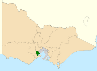
The electoral district of Tarneit is an electoral district of the Victorian Legislative Assembly. It was created before the 2002 election where it replaced the seat of Werribee.

The electoral district of Geelong is an electoral district of the Victorian Legislative Assembly. It centres on inner metropolitan Geelong and following the June 2013 redistribution of electoral boundaries includes the suburbs of Belmont, Breakwater, East Geelong, Geelong, Geelong West, Newtown and South Geelong, Herne Hill, Manifold Heights, Newcomb, Newtown, St Albans Park, Thomson, Whittington and part of Fyansford.

The Division of Melbourne Ports was an Australian federal electoral division in the inner south-eastern suburbs of Melbourne, Victoria, Australia. It was located to the south of Melbourne's central business district and covered an area of approximately 40 km2 around the north and north-eastern shores of Port Phillip Bay.

West Bourke was an electoral district of the Legislative Assembly in the Australian state of Victoria from 1856 to 1904.
The electoral district of Ringwood is an electoral district of the Victorian Legislative Assembly, located in the east of Melbourne. It was first proclaimed in 1958 and was abolished in 1992. Some of Ringwood was included in the new electoral district of Bayswater that year. Kay Setches, the last member for Ringwood, contested and lost Bayswater at the 1992 election.
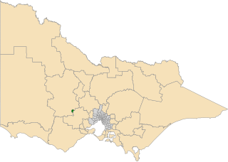
The electoral district of Wendouree is an electoral district of the Victorian Legislative Assembly in Australia. It was created in the redistribution of electoral boundaries in 2013, and came into effect at the 2014 state election.

The electoral district of Buninyong was an electoral district of the Victorian Legislative Assembly in Australia. It was created in the redistribution of electoral boundaries in 2013, and came into effect at the 2014 state election.

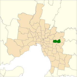
The electoral district of Clarinda is an electoral district of the Victorian Legislative Assembly in Australia. It was created in the redistribution of electoral boundaries in 2013, and came into effect at the 2014 state election.

The electoral district of Keysborough was an electoral district of the Victorian Legislative Assembly in Australia. It was created in the redistribution of electoral boundaries in 2013, and came into effect at the 2014 state election.

The Electoral district of Point Cook is an electoral district of the Victorian Legislative Assembly in Australia. It was created in the redistribution of electoral boundaries in 2021, and will come into effect at the 2022 Victorian state election.
