
The Division of Hindmarsh is an Australian Electoral Division in South Australia covering the western suburbs of Adelaide. The division was one of the seven established when the former Division of South Australia was split on 2 October 1903, and was first contested at the 1903 election, though on vastly different boundaries. The Division is named after Sir John Hindmarsh, who was Governor of South Australia from 1836 to 1838. The 78 km² seat extends from the coast in the west to South Road in the east, covering the suburbs of Ascot Park, Brooklyn Park, Edwardstown, Fulham, Glenelg, Grange, Henley Beach, Kidman Park, Kurralta Park, Morphettville, Plympton, Richmond, Semaphore Park, Torrensville, West Beach and West Lakes. The Adelaide International Airport is centrally located in the electorate, making noise pollution a prominent local issue, besides the aged care needs of the relatively elderly population − the seat has one of Australia's highest proportions of citizens over the age of 65. Progressive boundary redistributions over many decades transformed Hindmarsh from a safe Labor seat in to a marginal seat often won by the government of the day.

Adelaide is a single-member electoral district for the South Australian House of Assembly. The 22.8 km² state seat of Adelaide currently consists of the Adelaide city centre including North Adelaide and suburbs to the inner north and inner north east: Collinswood, Fitzroy, Gilberton, Medindie, Medindie Gardens, Ovingham, Thorngate, Walkerville, most of Prospect, and part of Nailsworth. The federal division of Adelaide covers the state seat of Adelaide and additional suburbs in each direction.
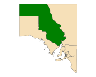
Giles is a single-member electoral district for the South Australian House of Assembly. Named after explorer Ernest Giles, it is the largest electorate in the state by area, covering 497,005 km2 (191,895 sq mi) of South Australian outback. Its main population centre is the industrial city of Whyalla on the far south-east border of the seat which represents half of the electorate's voters. The electorate covers significant areas of pastoral leases and Pitjantjatjara Aboriginal land stretching to the Western Australian and Northern Territory borders, taking in the remote towns of Andamooka, Coober Pedy, Ernabella, Fregon, Marla, Mimili, Mintabie, Oodnadatta, and Tarcoola. Giles also has a far north mobile booth.

Fisher was an electoral district of the House of Assembly in the Australian state of South Australia. It was created in 1970 and named after Sir James Fisher, a colonial politician and the first mayor of Adelaide. It was abolished in a 2016 redistribution and its last MP, Nat Cook was elected to represent its replacement, Hurtle Vale, at the 2018 state election. It covers a 94.2 km2 suburban and semi rural area on the southern fringes of Adelaide, taking in the suburbs of Aberfoyle Park, Chandlers Hill, Cherry Gardens, Coromandel East, Happy Valley, Reynella East and parts of Clarendon, O'Halloran Hill and Woodcroft.

Light is a single-member electoral district for the South Australian House of Assembly. Light is named after Colonel William Light, who was the first Surveyor-General of South Australia. The electorate was created in 1857, abolished at the 1902 election and recreated at the 1938 election. It is based on the semi-rural township of Gawler, and stretches southwards into the outermost northern suburbs of Adelaide.
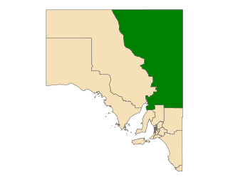
Stuart is a single-member electoral district for the South Australian House of Assembly. At 323,131 km², it is a vast country district extending from the Spencer Gulf as far as the Northern Territory border in the north and the Queensland and New South Wales borders in the east. The district includes pastoral lease and unincorporated Crown Lands, Lake Eyre and part of the Simpson Desert in the far north. Its main population centres since the 2020 boundaries redistribution are the industrial towns of Port Pirie and Port Augusta.

Unley is a single-member electoral district for the South Australian House of Assembly. Named after the suburb of the same name, it is the state's smallest electorate by area at just 14.1 km2 (5.4 sq mi). It is a suburban electorate in Adelaide's inner south, taking in the suburbs of Eastwood, Frewville, Fullarton, Glenside, Glenunga, Goodwood, Highgate, Hyde Park, Kings Park, Malvern, Myrtle Bank, Parkside, Unley, Unley Park and Wayville, as well as parts of Glen Osmond and Millswood.

The electoral district of Malvern is an electorate of the Victorian Legislative Assembly. It contains the suburbs of Malvern, Armadale, Kooyong, Malvern East, Toorak, and parts of Glen Iris.

The electoral district of Bass is one of the electoral districts of Victoria, Australia, for the Victorian Legislative Assembly. It covers an area of 1,358 square kilometres (524 sq mi) south east of Melbourne, stretching from the satellite suburb of Clyde through rural areas to the coast at Inverloch and Phillip Island. It includes the suburbs and towns of Bass, Cape Paterson, Clyde, Corinella, Cowes, Grantville, Inverloch, Kilcunda, Koo Wee Rup, Lang Lang, Pearcedale, Rhyll, San Remo, Tooradin, Ventnor and Wonthaggi. It lies within the Eastern Victoria Region of the upper house, the Legislative Council.

The electoral district of Bayswater is one of the electoral districts of Victoria, Australia, for the Victorian Legislative Assembly. It covers an area of 39 square kilometres (15 sq mi) in outer eastern Melbourne, and includes the suburbs of Bayswater, Heathmont, Kilsyth South and The Basin, and parts of Bayswater North, Boronia, Ringwood and Wantirna. It lies within the Eastern Metropolitan Region of the upper house, the Legislative Council.

The electoral district of Narre Warren North is an electorate of the Victorian Legislative Assembly and includes the suburbs of Hallam, Narre Warren, Narre Warren North and parts of Berwick, Endeavour Hills and Harkaway.

The electoral district of Essendon is an electoral district of the Victorian Legislative Assembly. It was first created in 1904 after the abolition of the larger Essendon and Flemington electorate, and covers some of the north-western suburbs of Melbourne, including Essendon, Moonee Ponds and Ascot Vale.

The electoral district of Evelyn is an electorate of the Victorian Legislative Assembly covering the urban fringe north east of Melbourne. It was first proclaimed in 1859.
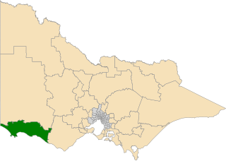
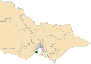
The electoral district of South-West Coast is an electorate of the Victorian Legislative Assembly. It was created prior to the 2002 election in order to replace the abolished seats of Portland and Warrnambool.

The electoral district of Carrum is an electoral district of the Victorian Legislative Assembly. It lies in the south eastern suburbs of Melbourne, covering Bangholme, Bonbeach, Carrum, Carrum Downs, Patterson Lakes, Sandhurst, Seaford and Skye.

The electoral district of Ivanhoe is an electoral district of the Victorian Legislative Assembly. It is located in the north-eastern suburbs of Melbourne and includes the suburbs of Heidelberg, Ivanhoe, Rosanna and Macleod.

The electoral district of Bentleigh is an electoral district of the Victorian Legislative Assembly. It covers an area of 25 square kilometres (9.7 sq mi) in southern Melbourne, including the suburbs of Bentleigh, Hampton East, McKinnon, and Moorabbin, and parts of Bentleigh East, Brighton East and Ormond. It also includes the Moorabbin campus of the Monash Medical Centre. It lies within the Southern Metropolitan Region of the upper house, the Legislative Council.

The electoral district of Caulfield is an electoral district of the Victorian Legislative Assembly that has existed since 1927.

South Barwon is an electoral district of the Legislative Assembly in the Australian state of Victoria. Located in a mixed urban and rural area south of the Barwon River, it covers an area of 621 km², including the Geelong suburbs of Belmont and Grovedale, Waurn Ponds and part of Highton, the coastal centre of Torquay and the rural towns of Barrabool, Bellbrae, Connewarre, Gnarwarre, Modewarre, Moriac and Mount Moriac. The electorate had a population of 52,241 at the 2001 census.
The electoral district of Bellarine is one of the electoral districts of Victoria, Australia, for the Victorian Legislative Assembly. It covers an area of 367 square kilometres (142 sq mi) stretching from the Bellarine Peninsula to the outer eastern suburbs of Geelong. It includes the towns of Barwon Heads, Clifton Springs, Drysdale, Indented Head, Ocean Grove, Point Lonsdale, Portarlington and Queenscliff and the Geelong suburbs of Leopold and Moolap. It lies within the Western Victoria Region of the upper house, the Legislative Council.
