Electoral district of Mordialloc

Last updated

Mordialloc
VictoriaLegislative Assembly
Electoral district of Mordialloc (Victoria) 2022.svg
Location of Mordialloc (dark green) in Greater Melbourne
State Victoria
Created1992
MP Tim Richardson
Party Labor
Electors 46,041 (2018)
Area56 km2 (21.6 sq mi)
DemographicOuter metropolitan

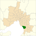
The electoral district of Mordialloc is an electorate of the Victorian Legislative Assembly [1] including the suburbs of Braeside, Mordialloc, Aspendale, Aspendale Gardens, Edithvale, Chelsea, Chelsea Heights and Parkdale; and parts of Cheltenham and Mentone. The current member is Tim Richardson.

Contents

Mordialloc is part of the Melbourne Sandbelt and is considered a Bellwether electorate. [2] Its previous members include Liberal representatives Lorraine Wreford and Geoff Leigh, and Labor member Janice Munt.

Members

MemberPartyTerm
  Geoff Leigh Liberal 1992–2002
  Janice Munt Labor 2002–2010
  Lorraine Wreford Liberal 2010–2014
  Tim Richardson Labor 2014–present

Election results

2022 Victorian state election: Mordialloc [3] [4] [5]
PartyCandidateVotes%±%
Labor Tim Richardson 19,39844.0−6.8
Liberal Phillip Pease13,82931.4+0.4
Greens Daniel Lessa4,52610.3+2.7
Independent Sarah O'Donnell3,2407.4+7.4
Animal Justice Chi Vo1,0702.4−0.7
Freedom Deborah Albrecht9552.2+2.2
Family First Patrick Lum8872.0+2.0
Independent Phil Reid1540.3+0.3
Total formal votes44,05995.6+1.6
Informal votes2,0354.4−1.6
Turnout 46,09491.0+3.5
Two-party-preferred result
Labor Tim Richardson 25,64058.2−5.2
Liberal Phillip Pease18,41941.8+5.2
Labor hold Swing −5.2

Related Research Articles

<span class="mw-page-title-main">Electoral district of Albert Park</span> State electoral district of Victoria, Australia

The electoral district of Albert Park is one of the electoral districts of Victoria, Australia, for the Victorian Legislative Assembly. It covers an area of 21 square kilometres (8.1 sq mi) in inner suburban Melbourne, and includes the suburbs of Albert Park, Middle Park, Port Melbourne, St Kilda West, Southbank, South Melbourne, South Wharf, and parts of St Kilda. It lies within the Southern Metropolitan Region of the upper house, the Legislative Council.

<span class="mw-page-title-main">Electoral district of Essendon</span> State electoral district of Victoria, Australia

The electoral district of Essendon is an electoral district of the Victorian Legislative Assembly. It was first created in 1904 after the abolition of the larger Essendon and Flemington electorate, and covers some of the north-western suburbs of Melbourne, including Essendon, Moonee Ponds and Ascot Vale.

<span class="mw-page-title-main">Electoral district of Monbulk</span> State electoral district of Victoria, Australia

The electoral district of Monbulk is an electoral district of the Victorian Legislative Assembly. It is situated in the Dandenong Ranges on the outskirts of Melbourne. It includes the towns of Monbulk, Olinda and Silvan as well as some outer suburbs such as Belgrave and Tecoma.

<span class="mw-page-title-main">Electoral district of Hawthorn</span> State electoral district of Victoria, Australia

The electoral district of Hawthorn is an electoral district of the Victorian Legislative Assembly. It was first proclaimed in 1888 taking effect at the 1889 elections.

<span class="mw-page-title-main">Electoral district of Nepean</span> State electoral district of Victoria, Australia

The electoral district of Nepean is an electorate of the Victorian Legislative Assembly covering the southernmost part of the Mornington Peninsula in Victoria, Australia. It is named after Point Nepean which is contained within the electorate.

<span class="mw-page-title-main">Electoral district of Yan Yean</span> State electoral district of Victoria, Australia

The electoral district of Yan Yean is an electoral district of the Victorian Legislative Assembly. It is located on the fringes of Melbourne's northern suburbs and contains the towns of Hurstbridge, Plenty, Whittlesea and Yan Yean.

<span class="mw-page-title-main">Electoral district of Evelyn</span>

The electoral district of Evelyn is an electorate of the Victorian Legislative Assembly covering the urban fringe north east of Melbourne. It was first proclaimed in 1859.

<span class="mw-page-title-main">Electoral district of Hastings</span>

The electoral district of Hastings is an electorate of the Victorian Legislative Assembly. It was created prior to the 2002 election due to population increases in Melbourne's outer south east. It covers Hastings, Tyabb, Somerville, Bittern and part of Langwarrin. French Island is also included within the electoral boundary.

<span class="mw-page-title-main">Electoral district of Frankston</span>

The electoral district of Frankston is an electoral district of the Victorian Legislative Assembly. It currently includes the suburbs of Frankston and Frankston South south east of Melbourne.

<span class="mw-page-title-main">Electoral district of Kororoit</span>

The electoral district of Kororoit is an electorate of the Victorian Legislative Assembly covering Albanvale, Caroline Springs as well as some parts of Deer Park and St Albans in the western suburbs of Melbourne.

<span class="mw-page-title-main">Electoral district of Carrum</span>

The electoral district of Carrum is an electoral district of the Victorian Legislative Assembly. It lies in the south eastern suburbs of Melbourne, covering Bangholme, Bonbeach, Carrum, Carrum Downs, Patterson Lakes, Sandhurst, Seaford and Skye.

<span class="mw-page-title-main">Electoral district of Warrandyte</span> State electoral district of Victoria, Australia

The electoral district of Warrandyte is an Australian electoral district of the Victorian Legislative Assembly. It is an outer metropolitan electorate and contains the suburbs of Park Orchards, Ringwood North, Warrandyte, Warrandyte North, Warrandyte South, Warranwood, Wonga Park, most of Donvale, and parts of Chirnside Park, Doncaster East, and Ringwood.

<span class="mw-page-title-main">Electoral district of Tarneit</span> State electoral district of Victoria, Australia

The electoral district of Tarneit is an electoral district of the Victorian Legislative Assembly. It was created before the 2002 election where it replaced the seat of Werribee.

<span class="mw-page-title-main">Electoral district of Preston</span>

The electoral district of Preston is an electoral district of the Victorian Legislative Assembly. It currently centres on the northern Melbourne suburbs of Preston and Reservoir. It has always been a safe Labor Party seat.

<span class="mw-page-title-main">Electoral district of Caulfield</span>

The electoral district of Caulfield is an electoral district of the Victorian Legislative Assembly. The electorate is surrounded by the other electoral districts of Prahran, Albert Park, Malvern, Oakleigh, Bentleigh and Brighton.

<span class="mw-page-title-main">Electoral district of Williamstown</span> State electoral district of Victoria, Australia

Williamstown is an electoral district of the Legislative Assembly in the Australian state of Victoria. It is a 33 km2 urban electorate in the inner south-western suburbs of Melbourne, encompassing the suburbs of Brooklyn, Newport, Spotswood, Williamstown and Yarraville. The electorate had a population of 54,426 as of the 2006 census.

<span class="mw-page-title-main">Electoral district of Oakleigh</span> State electoral district of Victoria, Australia

The electoral district of Oakleigh is an electoral district of the Victorian Legislative Assembly. It covers the south-east Melbourne suburbs of Carnegie, Murrumbeena, Hughesdale, Notting Hill, Oakleigh East, Oakleigh and parts of Chadstone, Glen Waverley, Mount Waverley, Glen Huntly, Mulgrave and Ormond.

<span class="mw-page-title-main">Electoral district of Mulgrave (Victoria)</span> State electoral district of Victoria, Australia

The electoral district of Mulgrave is situated in the south-east of the Melbourne Metropolitan Region. The electorate contains the suburbs of Mulgrave and Noble Park North. It also contains parts of the suburbs of Dandenong North, Noble Park, Springvale and Wheelers Hill.

<span class="mw-page-title-main">Electoral district of Footscray</span> State electoral district of Victoria, Australia

The electoral district of Footscray is an electoral district of the Victorian Legislative Assembly. It lies just north of Melbourne, covering the suburbs of Footscray, Maidstone, Maribyrnong, Seddon, West Footscray, and parts of Yarraville.

<span class="mw-page-title-main">Electoral district of Sandringham</span> State electoral district of Victoria, Australia

The electoral district of Sandringham is one of the electoral districts of Victoria, Australia, for the Victorian Legislative Assembly. It consists of the Melbourne bayside suburbs of Beaumaris, Black Rock and Sandringham, and parts of Cheltenham, Hampton, Highett, and Mentone.

References

  1. "Re-Member (Former Members)". State Government of Victoria. Retrieved 29 May 2014.
  2. "Victorian election result a Labor landslide with big swings in Melbourne's east - ABC News". ABC News. 24 November 2018.
  3. Green, Antony (11 January 2023). "VIC22 – 2-Party Preferred Results and Swings by District". Antony Green's Election Blog. Retrieved 28 January 2023.
  4. VIC 2021 Final Redistribution, ABC News. [Retrieved 1 January 2023.
  5. Mordialloc District results, Victorian Electoral Commission. Retrieved 1 December 2022.