Electoral district of Kew

Last updated

Kew
VictoriaLegislative Assembly
Electoral district of Kew
State Victoria
Created1927
MP Jess Wilson
Party Liberal
NamesakeSuburb of Kew
Electors 49,918 (2022) [1]
Area31.07 km2 (12.0 sq mi)
DemographicMetropolitan
Electorates around Kew:
Northcote Ivanhoe Bulleen
Richmond Kew Box Hill
Richmond Hawthorn Box Hill

The electoral district of Kew is an electoral district of the Victorian Legislative Assembly. Located in eastern Melbourne, a few kilometres from the city centre, it is centred on the suburbs of Kew and Kew East. It also contains Balwyn, Balwyn North, Deepdene, and parts of Canterbury, Mont Albert, and Surrey Hills.

Contents

The current member for Kew is Jess Wilson.

Geography

Kew from its northern boundary. Eastern Freeway and Melbourne skyline from Willsmere Park, Kew East (50857163393).jpg
Kew from its northern boundary.

The boundaries of the Victorian electoral districts and regions, including Kew, are determined by the independent and impartial Electoral Boundaries Commission. Redivisions typically occur when there have been two state elections since the last redivision. [2]

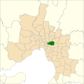
As of the 2022 Victorian state election, Kew follows the Yarra River along the north and west, follows Winfield Rd, Evelina St, Kerry Pde, Barloa Rd, and York St on the east, and follows Mont Albert Rd and Barkers Rd with the boundary extending down into Canterbury Rd between Balwyn Rd and Burke Rd on the south. [3]

In the boundary redistribution for the 2022 Victorian state election, Kew gained 6,514 voters from the Box Hill district. [1]

The seat is located almost entirely within the federal seat of Kooyong.

Demography

As per the 2021 census data, the district of Kew encompasses 64,029 people (not all being registered voters) and 26,076 private dwellings. 50% of residents in the district have attained a bachelor's degree or above, which is 20 points higher than the state average. 43% of residents stated they weren't religious, 21% of residents identified as catholic, 7% of residents identified as Anglican, and 6% of residents identified as Eastern Orthodox. [4]

96% of residents in the district of Kew that are in the labour force are employed. The median weekly personal income of residents is $991 ($188 higher that the state median), the median weekly household income of residents is $3,010 ($874 higher that the state median). [4]

60% of residents in the district of Kew were born in Australia and 11% of residents were born in China. 24% of residents stated they have Chinese ancestry, 24% of residents stated they have English ancestry, and 20% of residents stated they had Australian ancestry. 62% of residents have had at least one of their parents born overseas. [4]

History

The seat was created in 1927 and has generally been a safe seat for the Liberal Party and its predecessors. The most notable former member is Dick Hamer, who was Premier of Victoria from 1972 until 1981. From 1927 to 1981, it was held by only three members, all of whom eventually became Deputy PremiersWilfrid Kent Hughes, Arthur Rylah and Hamer.[ citation needed ]

In 1851, Nicholas Fenwick purchased 122 acres (Lot 87) [5] for four pounds and six shillings per acre and named the allotment Kew. In naming Kew, he is believed to have said "Kew in England is near Richmond, this place is near Richmond, why not call it Kew?". [6]

Members for Kew

OrderImageMemberPartyTermNotes
1 Kenthughes.jpg Wilfrid Kent Hughes
(1895–1970)
  Nationalist 9 April 1927 –
1931
Served as minister under McPherson and Argyle.
Served as Deputy Premier under Argyle and Hollway. Retired.
Later held the federal seat of Chisholm and served as minister under Menzies. [7]
  United Australia 1931–1945
  Liberal / LCP 1945 –
31 October 1949
2 Arthur Rylah .jpg Arthur Rylah
(1909–1974)
  LCP / Liberal 17 December 1949 –
5 March 1971
Served as Deputy Premier under Bolte. Retired. [8]
3 Dick Hamer.jpg Dick Hamer
(1916–2004)
  Liberal 17 April 1971 –
17 July 1981
Previously a member of the Victorian Legislative Council.
Served as minister under Bolte.
Served as Premier from 1972 to 1981. Retired. [9]
4 Prue Sibree
(1946–)
  Liberal 15 August 1981 –
19 March 1988
Retired. [10]
5 Jan Wade
(1937–)
  Liberal 19 March 1988 –
17 September 1999
Served as minister under Kennett. Retired. [11]
6 Kew Festival28.jpg Andrew McIntosh
(1955–)
  Liberal 18 September 1999 –
29 November 2014
Served as minister under Baillieu and Napthine. Resigned. [12]
7 Tim Smith immediately after being preselected as the Liberal candidate for Kew 2 March 2014 at Xavier College Kew. Credit CS (cropped).jpg Tim Smith
(1983–)
  Liberal 29 November 2014 –
26 November 2022
Retired. [13]
8 Jess Wilson
(1990–)
  Liberal 26 November 2022 –
present
Incumbent.

Election results

2022 Victorian state election: Kew [14] [15] [16]
PartyCandidateVotes%±%
Liberal Jess Wilson 19,32144.3−5.0
Labor Lucy Skelton9,89622.7−8.8
Independent Sophie Torney9,20021.1+21.1
Greens Jackie Carter3,6128.3−6.9
Family First Ann Seeley7511.7+1.7
Animal Justice Ruby Schofield5071.2−0.9
Independent Finlay Davis1580.4+0.4
Independent Kym Sullivan1470.3+0.3
Total formal votes43,59297.0+1.1
Informal votes1,3673.0−1.1
Turnout 44,95990.1−2.3
Two-party-preferred result
Liberal Jess Wilson 23,52954.0−0.7
Labor Lucy Skelton20,06346.0+0.7
Liberal hold Swing –0.7

See also

Related Research Articles

<span class="mw-page-title-main">Premier of Victoria</span> Head of government in the state of Victoria

The premier of Victoria is the head of government of the Australian state of Victoria. The premier leads the Cabinet of Victoria and selects its ministers. The premier is appointed by the governor of Victoria and must be a member of the Legislative Assembly, and command confidence in the house. This typically means being the leader of a political party who has the support of a majority of lower house members.

<span class="mw-page-title-main">Electoral districts of Victoria</span> Constituency of the Victorian Legislative Assembly

Electoral districts of Victoria are the electoral districts, commonly referred to as "seats" or "electorates", into which the Australian State of Victoria is divided for the purpose of electing members of the Victorian Legislative Assembly, one of the two houses of the Parliament of the State. The State is divided into 88 single-member districts. The Legislative Assembly has had 88 electorates since the 1985 election, increased from 81 previously.

<span class="mw-page-title-main">Arthur Rylah</span> Australian politician

Sir Arthur Gordon Rylah, was an Australian politician and lawyer who served as Deputy Premier of Victoria from 1955 to 1971.

<span class="mw-page-title-main">Electoral district of Malvern</span> State electoral district of Victoria, Australia

The electoral district of Malvern is an electorate of the Victorian Legislative Assembly. It contains the suburbs of Malvern, Armadale, Kooyong, Malvern East, Toorak, and parts of Glen Iris.

<span class="mw-page-title-main">Electoral district of Altona</span> State electoral district of Victoria, Australia

The electoral district of Altona was one of the electoral districts of Victoria, Australia, for the Victorian Legislative Assembly. It covered an area of 79 square kilometres (31 sq mi) in western Melbourne, and included the suburbs of Altona, Altona Meadows, Laverton, Point Cook, Seabrook and Seaholme. It also included the RAAF Williams airbase and the Point Cook Coastal Park. It lay within the Western Metropolitan Region of the upper house, the Legislative Council.

<span class="mw-page-title-main">Electoral district of Bayswater</span> State electoral district of Victoria, Australia

The electoral district of Bayswater is one of the electoral districts of Victoria, Australia, for the Victorian Legislative Assembly. It covers an area of 39 square kilometres (15 sq mi) in outer eastern Melbourne, and includes the suburbs of Bayswater, Heathmont, Kilsyth South and The Basin, and parts of Bayswater North, Boronia, Ringwood and Wantirna. It lies within the Eastern Metropolitan Region of the upper house, the Legislative Council.

<span class="mw-page-title-main">Electoral district of Brunswick</span> State electoral district of Victoria, Australia

The electoral district of Brunswick is an electorate of the Victorian Legislative Assembly. It covers an area of 14 square kilometres (5.4 sq mi) in inner northern Melbourne, and includes the suburbs of Brunswick, Brunswick East, Carlton North, Fitzroy North, Princes Hill and parts of Brunswick West. It lies within the Northern Metropolitan Region of the upper house, the Legislative Council.

<span class="mw-page-title-main">Electoral district of Williamstown</span> State electoral district of Victoria, Australia

Williamstown is an electoral district of the Legislative Assembly in the Australian state of Victoria. It is a 33 km2 urban electorate in the inner south-western suburbs of Melbourne, encompassing the suburbs of Brooklyn, Newport, Spotswood, Williamstown, Williamstown North, South Kingsville, Seaholme, Altona and Yarraville. The electorate had a population of 54,426 as of the 2006 census.

<span class="mw-page-title-main">Electoral district of Broadmeadows</span> State electoral district of Victoria, Australia

The electoral district of Broadmeadows is an electorate of the Victorian Legislative Assembly. It covers an area of 47 square kilometres (18 sq mi) in outer northern Melbourne, and includes the suburbs of Broadmeadows, Campbellfield, Coolaroo, Dallas, Fawkner, Jacana and Meadow Heights. It also includes parts of Glenroy, Roxburgh Park, Somerton, and Westmeadows. It lies within the Northern Metropolitan Region of the upper house, the Legislative Council.

<span class="mw-page-title-main">Electoral district of Bulleen</span> State electoral district of Victoria, Australia

The electoral district of Bulleen is an electoral district of the Victorian Legislative Assembly. It covers an area of 39 square kilometres (15 sq mi) in eastern Melbourne, including the suburbs of Bulleen, Doncaster, Templestowe Lower, and part of Templestowe. It lies within the Eastern Metropolitan Region of the upper house, the Legislative Council.

<span class="mw-page-title-main">Electoral district of Bundoora</span> State electoral district of Victoria, Australia

Bundoora is an electoral district of the Victorian Legislative Assembly. It covers an area of 35 square kilometres (14 sq mi) in north-eastern Melbourne, encompassing the suburbs of Bundoora, Kingsbury, Watsonia and Watsonia North, and parts of Greensborough, Macleod, Mill Park and Yallambie. It also includes the central campus of La Trobe University. It lies within the Northern Metropolitan Region of the upper house, the Legislative Council.

<span class="mw-page-title-main">Electoral district of Korong and Eaglehawk</span> Former electoral district of Victoria, Australia

Electoral district of Korong and Eaglehawk was an electoral district of the Legislative Assembly in the Australian state of Victoria.

The Electoral district of Rainbow was an electoral district of the Victorian Legislative Assembly.

This is a list of electoral results for the Electoral district of Kew in Victorian state elections.

<span class="mw-page-title-main">Electoral district of South Bourke</span> Colonial electoral district of Victoria, Australia

The Electoral district of South Bourke was an electoral district of the Legislative Assembly in then Australian colony of Victoria. It was one of the original 36 electoral districts of the Assembly. It covered an area east of Melbourne, bounded by Dandenong Creek in the south and east, Moorabbin, Prahran and Hawthorn in the west and Templestowe in the north. It was abolished in 1889.

<span class="mw-page-title-main">Electoral district of Loddon</span> Former electoral district of Victoria, Australia

Loddon was an electoral district of the Legislative Assembly in the Australian state of Victoria from 1856 to 1859. It was based in northern Victoria around the Loddon River.

<span class="mw-page-title-main">Electoral district of Ovens</span> Former electoral district in Victoria, Australia

Ovens was an electoral district of the Legislative Assembly in the Australian state of Victoria from 1856 to 1927. It was based in northern Victoria, bordered by the Ovens River in the south-west and included the town of Beechworth, Victoria.

<span class="mw-page-title-main">Electoral district of Geelong East</span> State electoral district of Victoria, Australia (1976–1985)

Geelong East was an electoral district of the Legislative Assembly in the Australian state of Victoria from 1859 to 1985. It was located south of the city of Geelong, defined in the Victorian Electoral Act, 1858 as:

Commencing at the north-western angle of the town reserve of Geelong; thence by a line south to the River Barwon; thence westward and northwestward by the River Barwon to the western boundary of the reserve at the junction of the Moorabool and Barwon; thence east by the northern boundary of section 25, parish of Barrabool; thence south by the eastern boundaries of sections 25 and 11, and by part of the eastern boundary of section 7, all in the same parish; thence south-easterly by a curved line crossing the Waurn Chain of Ponds to the southern boundary of section 3, parish of Conewarre; thence east by the southern boundaries of sections 3 and 4 in the same parish; thence north-easterly by a curved line crossing the River Barwon to the south-eastern angle of section 11 in the parish of Moolap; thence by the eastern boundary of that section and a line north to the shores of Corio Bay; and thence by the shores of Corio Bay to the north-western angle of the town reserve, the commencing point aforesaid, including the remaining portion of the reserve at Point Henry.

<span class="mw-page-title-main">Electoral district of Kyneton</span> Former state electoral district of Victoria, Australia

Kyneton was an electoral district of the Legislative Assembly in the Australian state of Victoria centred on Kyneton from 1889 to 1904.

This is a list of electoral results for the electoral district of Ovens in Victorian state elections.

References

  1. 1 2 "Kew District results". Victorian Electoral Commission . Retrieved 28 December 2022.
  2. "State boundary reviews". Victorian Electoral Commission . Retrieved 28 December 2022.
  3. "Electoral District Kew" (PDF). Electoral Boundaries Commission . October 2021. Retrieved 28 December 2022.
  4. 1 2 3 "Kew (Southern Metropolitan) - 2021 Census All persons QuickStats". Australian Bureau of Statistics . 2021. Retrieved 28 December 2022.
  5. "Our Story". Kew Primary School. Retrieved 3 April 2023.
  6. Barnard, Francis George Allman (1910). The Jubilee History of Kew, Victoria : Its Origin and Progress. E.F.G. Hodges "Mercury" Office. p. 10. Retrieved 3 April 2023.
  7. "Sir Wilfrid Selwyn Kent Hughes". Re-Member: a database of all Victorian MPs since 1851. Parliament of Victoria. 28 August 2019. Archived from the original on 23 April 2023.
  8. "Sir Arthur Gordon Rylah (CBE KMG)". Re-Member: a database of all Victorian MPs since 1851. Parliament of Victoria. 28 August 2019. Archived from the original on 23 April 2023.
  9. "Sir Rupert James Hamer (KCMG)". Re-Member: a database of all Victorian MPs since 1851. Parliament of Victoria. 28 August 2019. Archived from the original on 23 April 2023.
  10. "Prudence Anne Sibree". Re-Member: a database of all Victorian MPs since 1851. Parliament of Victoria. 20 February 2019. Archived from the original on 23 April 2023.
  11. "Jan Louise Murray Wade". Re-Member: a database of all Victorian MPs since 1851. Parliament of Victoria. 20 November 2018. Archived from the original on 23 April 2023.
  12. "Andrew McIntosh". Re-Member: a database of all Victorian MPs since 1851. Parliament of Victoria. 20 November 2018. Archived from the original on 23 April 2023.
  13. "Mr Timothy Colin Smith". Re-Member: a database of all Victorian MPs since 1851. Parliament of Victoria. 14 December 2022. Archived from the original on 23 April 2023.
  14. Green, Antony (11 January 2023). "VIC22 – 2-Party Preferred Results and Swings by District". Antony Green's Election Blog. Retrieved 28 January 2023.
  15. VIC 2021 Final Redistribution, ABC News. [Retrieved 1 January 2023.
  16. "Kew District results". Victorian Electoral Commission . Retrieved 1 December 2022.