Peter James Loney was an Australian politician. He was an Australian Labor Party member of the Victorian Legislative Assembly from 1992 to 2006, representing the electorates of Geelong North (1992-2002) and its successor Lara (2002-2006). He also served as Deputy Speaker of the Legislative Assembly.
The electoral district of Altona was one of the electoral districts of Victoria, Australia, for the Victorian Legislative Assembly. It covered an area of 79 square kilometres (31 sq mi) in western Melbourne, and included the suburbs of Altona, Altona Meadows, Laverton, Point Cook, Seabrook and Seaholme. It also included the RAAF Williams airbase and the Point Cook Coastal Park. It lay within the Western Metropolitan Region of the upper house, the Legislative Council.

The electoral district of Bayswater is one of the electoral districts of Victoria, Australia, for the Victorian Legislative Assembly. It covers an area of 39 square kilometres (15 sq mi) in outer eastern Melbourne, and includes the suburbs of Bayswater, Heathmont, Kilsyth South and The Basin, and parts of Bayswater North, Boronia, Ringwood and Wantirna. It lies within the Eastern Metropolitan Region of the upper house, the Legislative Council.
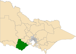
The electoral district of Polwarth is an electoral district of the Victorian Legislative Assembly. It is located in south-west rural Victoria, west of Geelong, and covers the Colac and Corangamite local government areas (LGA), parts of the Moyne, Golden Plains and Surf Coast LGAs, and slivers of the Ararat and Greater Geelong LGAs, running along the Great Ocean Road taking in Anglesea, Cape Otway, Peterborough, Aireys Inlet, Lorne, Wye River, Apollo Bay and Port Campbell, covering the inland towns of Winchelsea, Colac, Camperdown and Terang along the Princes Highway, and Inverleigh, Cressy, Lismore and Mortlake on the Hamilton Highway, and finally, includes the Otway Ranges and Lake Corangamite.

The electoral district of Essendon is an electoral district of the Victorian Legislative Assembly. It was first created in 1904 after the abolition of the larger Essendon and Flemington electorate, and covers some of the north-western suburbs of Melbourne, including Essendon, Moonee Ponds and Ascot Vale.

The electoral district of Dandenong is an electoral district of the Victorian Legislative Assembly. It was first proclaimed in 1904 when the district of Dandenong and Berwick was abolished.

The electoral district of Yan Yean is an electoral district of the Victorian Legislative Assembly. It is located on the fringes of Melbourne's northern suburbs and contains the towns of Hurstbridge, Plenty, Whittlesea and Yan Yean.
The electoral district of Ferntree Gully was an electorate of the Victorian Legislative Assembly. It was created in 2002 as a replacement for the abolished electorate of Knox.
The electoral district of Frankston is an electoral district of the Victorian Legislative Assembly. It currently includes the suburbs of Frankston and Frankston South south east of Melbourne.

The electoral district of Northcote is an electoral district of the Victorian Legislative Assembly. It covers the suburbs of Alphington, Fairfield, Northcote, Thornbury, and part of Preston. It lies on the northern bank of the Yarra River between the Merri and Darebin creeks.

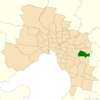
The electoral district of Warrandyte is an Australian electoral district of the Victorian Legislative Assembly. It is an outer metropolitan electorate and contains the suburbs of Park Orchards, Ringwood North, Warrandyte, Warrandyte North, Warrandyte South, Warranwood, Wonga Park, most of Donvale, and parts of Chirnside Park, Doncaster East, and Ringwood.
The electoral district of Brunswick is an electorate of the Victorian Legislative Assembly. It covers an area of 14 square kilometres (5.4 sq mi) in inner northern Melbourne, and includes the suburbs of Brunswick, Brunswick East, Carlton North, Fitzroy North, Princes Hill and parts of Brunswick West. It lies within the Northern Metropolitan Region of the upper house, the Legislative Council.

The electoral district of Tarneit is an electoral district of the Victorian Legislative Assembly. It was created before the 2002 election where it replaced the seat of Werribee.

The electoral district of Geelong is an electoral district of the Victorian Legislative Assembly. It centres on inner metropolitan Geelong and following the June 2013 redistribution of electoral boundaries includes the suburbs of Belmont, Breakwater, East Geelong, Geelong, Geelong West, Newtown and South Geelong, Herne Hill, Manifold Heights, Newcomb, Newtown, St Albans Park, Thomson, Whittington and part of Fyansford.

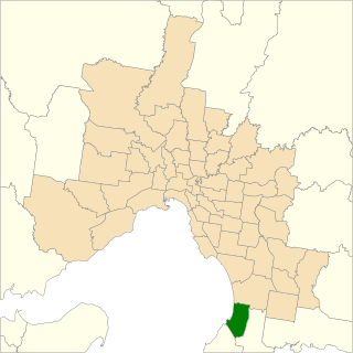
South Barwon is an electoral district of the Legislative Assembly in the Australian state of Victoria. Located in a mixed urban and rural area south of the Barwon River, it covers an area of 621 km², including the Geelong suburbs of Belmont and Grovedale, Waurn Ponds and part of Highton, the coastal centre of Torquay and the rural towns of Barrabool, Bellbrae, Connewarre, Gnarwarre, Modewarre, Moriac and Mount Moriac. The electorate had a population of 52,241 at the 2001 census.

The electoral district of Footscray is an electoral district of the Victorian Legislative Assembly. It lies just north of Melbourne, covering the suburbs of Footscray, Maidstone, Maribyrnong, Seddon, West Footscray, and parts of Yarraville.
Bundoora is an electoral district of the Victorian Legislative Assembly. It covers an area of 35 square kilometres (14 sq mi) in north-eastern Melbourne, encompassing the suburbs of Bundoora, Kingsbury, Watsonia and Watsonia North, and parts of Greensborough, Macleod, Mill Park and Yallambie. It also includes the central campus of La Trobe University. It lies within the Northern Metropolitan Region of the upper house, the Legislative Council.
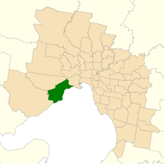
The electoral district of Bellarine is one of the electoral districts of Victoria, Australia, for the Victorian Legislative Assembly. It covers an area of 367 square kilometres (142 sq mi) stretching from the Bellarine Peninsula to the outer eastern suburbs of Geelong. It includes the towns of Barwon Heads, Clifton Springs, Drysdale, Indented Head, Ocean Grove, Point Lonsdale, Portarlington and Queenscliff and the Geelong suburbs of Leopold and Moolap. It lies within the Western Victoria Region of the upper house, the Legislative Council.
The electoral district of Ringwood is an electoral district of the Victorian Legislative Assembly, located in the east of Melbourne. It was first proclaimed in 1958 and was abolished in 1992. Some of Ringwood was included in the new electoral district of Bayswater that year. Kay Setches, who was at the time the last member for Ringwood, contested and lost Bayswater at the 1992 election.

The electoral district of Ashwood is an electorate of the Victorian Legislative Assembly in Melbourne, Australia. It was created in the redistribution of electoral boundaries in 2021, and came into effect at the 2022 Victorian state election.
