
The electoral district of Malvern is an electorate of the Victorian Legislative Assembly. It contains the suburbs of Malvern, Armadale, Kooyong, Malvern East, Toorak, and parts of Glen Iris.

Cranbourne is an electoral district of the Victorian Legislative Assembly. It is located south-east of Melbourne and includes the suburbs of Botanic Ridge, Cranbourne, Cranbourne East, Cranbourne North, Cranbourne West, Junction Village, as well as parts of Clyde, Clyde North, Cranbourne South, Devon Meadows, Lynbrook and Lyndhurst. It was created prior to the 1992 state election.
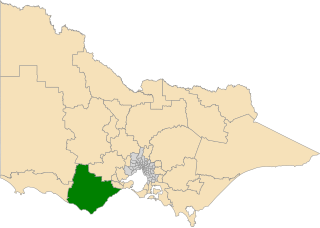
The electoral district of Polwarth is an electoral district of the Victorian Legislative Assembly. It is located in south-west rural Victoria, west of Geelong, and covers the Colac and Corangamite local government areas (LGA), parts of the Moyne, Golden Plains and Surf Coast LGAs, and slivers of the Ararat and Greater Geelong LGAs, running along the Great Ocean Road taking in Anglesea, Cape Otway, Peterborough, Aireys Inlet, Lorne, Wye River, Apollo Bay and Port Campbell, covering the inland towns of Winchelsea, Colac, Camperdown and Terang along the Princes Highway, and Inverleigh, Cressy, Lismore and Mortlake on the Hamilton Highway, and finally, includes the Otway Ranges and Lake Corangamite.

The electoral district of Essendon is an electoral district of the Victorian Legislative Assembly. It was first created in 1904 after the abolition of the larger Essendon and Flemington electorate, and covers some of the north-western suburbs of Melbourne, including Essendon, Moonee Ponds and Ascot Vale.

The electoral district of Monbulk is an electoral district of the Victorian Legislative Assembly. It is situated in the Dandenong Ranges on the outskirts of Melbourne. It includes the towns of Monbulk, Olinda and Silvan as well as some outer suburbs such as Belgrave and Tecoma.

The electoral district of Eltham is an electoral district of the Victorian Legislative Assembly. It is an outer metropolitan electorate and contains Eltham, Lower Plenty as well as parts of Greensborough and Kangaroo Ground.

The electoral district of Hawthorn is an electoral district of the Victorian Legislative Assembly. It was first proclaimed in 1888 taking effect at the 1889 elections.

The electoral district of Thomastown is an electorate of the Victorian Legislative Assembly. It currently includes the suburbs of Lalor and Thomastown, and parts of Fawkner, Reservoir and Wollert, and has been in existence since 1985.

The electoral district of Kororoit is an electorate of the Victorian Legislative Assembly covering Albanvale, Caroline Springs as well as some parts of Deer Park and St Albans in the western suburbs of Melbourne.

The electoral district of Warrandyte is an Australian electoral district of the Victorian Legislative Assembly. It is an outer metropolitan electorate and contains the suburbs of Park Orchards, Ringwood North, Warrandyte, Warrandyte North, Warrandyte South, Warranwood, Wonga Park, most of Donvale, and parts of Chirnside Park, Doncaster East, and Ringwood.

The electoral district of Bentleigh is an electoral district of the Victorian Legislative Assembly. It covers an area of 25 square kilometres (9.7 sq mi) in southern Melbourne, including the suburbs of Bentleigh, Hampton East, McKinnon, and Moorabbin, and parts of Bentleigh East, Brighton East and Ormond. It also includes the Moorabbin campus of the Monash Medical Centre. It lies within the Southern Metropolitan Region of the upper house, the Legislative Council.

The electoral district of Geelong is an electoral district of the Victorian Legislative Assembly. It centres on inner metropolitan Geelong and following the June 2013 redistribution of electoral boundaries includes the suburbs of Belmont, Breakwater, East Geelong, Geelong, Geelong West, Newtown and South Geelong, Herne Hill, Manifold Heights, Newcomb, Newtown, St Albans Park, Thomson, Whittington and part of Fyansford.

The electoral district of Caulfield is an electoral district of the Victorian Legislative Assembly. The electorate is surrounded by the other electoral districts of Prahran, Albert Park, Malvern, Oakleigh, Bentleigh and Brighton.

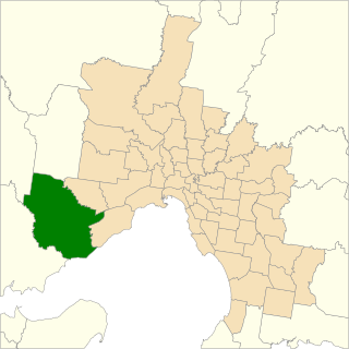
Williamstown is an electoral district of the Legislative Assembly in the Australian state of Victoria. It is a 33 km2 urban electorate in the inner south-western suburbs of Melbourne, encompassing the suburbs of Brooklyn, Newport, Spotswood, Williamstown and Yarraville. The electorate had a population of 54,426 as of the 2006 census.

The electoral district of Lowan is a rural Victorian Legislative Assembly electoral district of the Victorian Parliament. It is located within the Western Victoria Region of the Legislative Council. It was initially created by the Electoral Act Amendment Act 1888, taking effect at the 1889 elections. It is the state’s biggest electorate by area, covering about 41,858 km².

The electoral district of Shepparton is a rural Lower House electoral district of the Victorian Parliament. It is located within the Northern Victoria Region of the Legislative Council.

The electoral district of Sandringham is one of the electoral districts of Victoria, Australia, for the Victorian Legislative Assembly. It consists of the Melbourne bayside suburbs of Beaumaris, Black Rock and Sandringham, and parts of Cheltenham, Hampton, Highett, and Mentone.

Bendigo West is an electoral district of the Legislative Assembly in the Australian state of Victoria. It is a 1,524 square kilometres (588 sq mi) electorate centred on the city of Bendigo west of the Yungera railway line, and including surrounding rural towns to the west and south-west. It encompasses the localities of Bendigo City, California Gully, Castlemaine, Harcourt, Long Gully, Maldon, Marong, Newstead and West Bendigo. It also includes parts of the Bendigo suburbs of Eaglehawk, Golden Square and Kangaroo Flat. It lies within the Northern Victoria Region of the upper house, the Legislative Council.
The electoral district of Werribee is an electoral district of the Legislative Assembly in the Australian state of Victoria. It has existed in two incarnations, first from 1976 to 2002, and was created again in the 2013 redistribution and came into effect at the 2014 state election.
This is a list of electoral district results for the 2022 Victorian state election for the Legislative Assembly.
