The City of Ballarat is a local government area in the west of the state of Victoria, Australia. It covers an area of 739 square kilometres (285 sq mi) and, in June 2018, had a population of 107,325. It is primarily urban with the vast majority of its population living in the Greater Ballarat urban area, while other significant settlements within the LGA include Buninyong, Waubra, Learmonth and Addington. It was formed in 1994 from the amalgamation of the City of Ballarat, Shire of Ballarat, Borough of Sebastopol and parts of the Shire of Bungaree, Shire of Buninyong, Shire of Grenville and Shire of Ripon.

The Division of Deakin is an Australian Electoral Division in Victoria.

The Division of Jagajaga is an Australian Electoral Division in the state of Victoria. It is located in the north-eastern suburbs of Melbourne, and lies north of the Yarra River. It covers an area of approximately 104 square kilometres and comprises the suburbs of Bellfield, Briar Hill, Diamond Creek, Eaglemont, Greensborough, Heidelberg, Heidelberg Heights, Heidelberg West, Ivanhoe, Ivanhoe East, Lower Plenty, Montmorency, Plenty, Rosanna, St Helena, Viewbank, Yallambie, Watsonia and Watsonia North; and parts of Bundoora, Eltham, Eltham North, Hurstbridge, Macleod, Wattle Glen and Yarrambat.
Ballarat East was an electoral district of the Legislative Assembly in the Australian state of Victoria. Prior to its abolition, it was a 3,323 km² part-urban and part-rural electorate covering areas to the east of the regional centre of Ballarat. It included the Ballarat suburbs of Ballarat East, Bakery Hill, Golden Point, Eureka, Canadian, Mount Pleasant, Mount Clear, Mount Helen and Warrenheip, and the rural towns of Ballan, Buninyong, Bungaree, Creswick, Daylesford, Dunnstown, Hepburn Springs, Kyneton, Lal Lal, Malmsbury, Meredith and Steiglitz. The electorate had a population of 54,127 as of the 2006 census, with 40,578 enrolled electors at the 2010 state election.

The Electoral district of Ballarat West was an electoral district of the Victorian Legislative Assembly in Australia. It existed from 1859–1927 and from 1992–2014.
The Electoral district of Clayton is a former electoral district of the Victorian Legislative Assembly. It was named for the Melbourne suburb of Clayton, and also includes Clarinda, Notting Hill as well as parts of surrounding suburbs.

The electoral district of Geelong is an electoral district of the Victorian Legislative Assembly. It centres on inner metropolitan Geelong and following the June 2013 redistribution of electoral boundaries includes the suburbs of Belmont, Breakwater, East Geelong, Geelong, Geelong West, Newtown and South Geelong, Herne Hill, Manifold Heights, Newcomb, Newtown, St Albans Park, Thomson, Whittington and part of Fyansford.

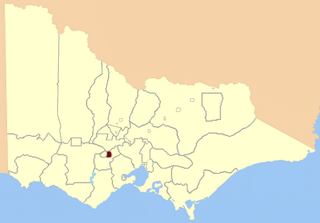
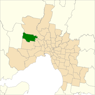
Ripon is a single member electoral district of the Victorian Legislative Assembly. It is a rural electorate based in western Victoria. In 1946 the electoral district of Ripon was first contested but then abolished in the 1955 election after being held by Labor for seven of these years. Ripon was re-created in 1976, essentially as a replacement for Hampden and Kara Kara.
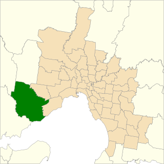
The electoral district of Werribee is an electoral district of the Legislative Assembly in the Australian state of Victoria. It has existed in two incarnations, first from 1976 to 2002, and was created again in the 2013 redistribution and came into effect at the 2014 state election.

The City of Ballaarat was a local government area covering the inner suburbs of the regional city of Ballarat, Victoria, Australia. The city covered an area of 34.52 square kilometres (13.3 sq mi), and existed from 1855 until 1994.

The Shire of Ballarat was a local government area immediately to the northwest and west of the regional city of Ballarat, Victoria, Australia. The shire covered an area of 481.74 square kilometres (186.0 sq mi), and existed from 1856 until 1994.
Nollamara was an electoral district of the Legislative Assembly in the Australian state of Western Australia.

The 2014 Victorian state election, held on Saturday, 29 November 2014, was for the 58th Parliament of Victoria. All 88 seats in the Victorian Legislative Assembly and 40 seats in the Victorian Legislative Council were up for election. The incumbent centre-right Coalition minority government, led by Liberal Party leader and Premier Denis Napthine and National Party leader and Deputy Premier Peter Ryan, was defeated by the centre-left Labor Party opposition, led by Daniel Andrews. The Greens won two lower house seats, their first Legislative Assembly seats in a Victorian state election, whilst increasing their share of upper house seats. The new Andrews Ministry was sworn in on 4 December 2014.
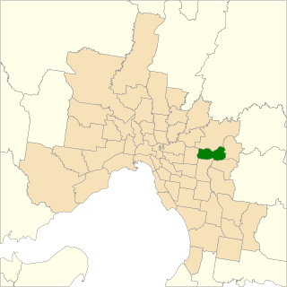
The electoral district of Ringwood is an electoral district of the Victorian Legislative Assembly, located in the east of Melbourne. It was first proclaimed in 1958 and was abolished in 1992. Some of Ringwood was included in the new electoral district of Bayswater that year. Kay Setches, who was at the time the last member for Ringwood, contested and lost Bayswater at the 1992 election.

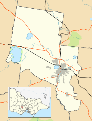
The electoral district of Buninyong was an electoral district of the Victorian Legislative Assembly in Australia. It was created in the redistribution of electoral boundaries in 2013, and came into effect at the 2014 state election.

The electoral district of Clarinda is an electoral district of the Victorian Legislative Assembly in Australia. It was created in the redistribution of electoral boundaries in 2013, and came into effect at the 2014 state election.

The electoral district of Keysborough was an electoral district of the Victorian Legislative Assembly in Australia. It was created in the redistribution of electoral boundaries in 2013, and came into effect at the 2014 state election.
The electoral district of Sydenham is an electoral district of the Victorian Legislative Assembly in Australia. It was created in the redistribution of electoral boundaries in 2013, and came into effect at the 2014 state election.

The Electoral district of Eureka is an electoral district of the Victorian Legislative Assembly in Australia. It was created in the redistribution of electoral boundaries in 2021, and came into effect at the 2022 Victorian state election.

The electoral district of Ashwood is an electorate of the Victorian Legislative Assembly in Melbourne, Australia. It was created in the redistribution of electoral boundaries in 2021, and came into effect at the 2022 Victorian state election.
