
A glacier is a persistent body of dense ice that is constantly moving downhill under its own weight. A glacier forms where the accumulation of snow exceeds its ablation over many years, often centuries. It acquires distinguishing features, such as crevasses and seracs, as it slowly flows and deforms under stresses induced by its weight. As it moves, it abrades rock and debris from its substrate to create landforms such as cirques, moraines, or fjords. Although a glacier may flow into a body of water, it forms only on land and is distinct from the much thinner sea ice and lake ice that form on the surface of bodies of water.

Mount Timpanogos, often referred to as Timp, is the second-highest mountain in Utah's Wasatch Range. Timpanogos rises to an elevation of 11,752 ft (3,582 m) above sea level in the Uinta-Wasatch-Cache National Forest. With 5,270 ft (1,610 m) of topographic prominence, Timpanogos is the 47th-most prominent mountain in the contiguous United States.

The Shackleton Range is a mountain range in Antarctica that rises to 1,875 metres (6,152 ft) and extends in an east–west direction for about 100 miles (160 km) between the Slessor and Recovery Glaciers.

Glacial landforms are landforms created by the action of glaciers. Most of today's glacial landforms were created by the movement of large ice sheets during the Quaternary glaciations. Some areas, like Fennoscandia and the southern Andes, have extensive occurrences of glacial landforms; other areas, such as the Sahara, display rare and very old fossil glacial landforms.

The Trinity Alps are a mountain range in Trinity County and Siskiyou County in Northern California. They are a subrange of the Klamath Mountains located to the north of Weaverville.

A tunnel valley is a U-shaped valley originally cut under the glacial ice near the margin of continental ice sheets such as that now covering Antarctica and formerly covering portions of all continents during past glacial ages. They can be as long as 100 km (62 mi), 4 km (2.5 mi) wide, and 400 m (1,300 ft) deep.

The Crater Glacier is a geologically young glacier on Mount St. Helens, in the U.S. state of Washington. The glacier formed after the 1980 eruption and due to its location, the body of ice grew rapidly, unknown to the public for nearly 20 years. The glacier once contained ice caves in the smooth ice before the 2004–2008 volcanic activity. The growth of the lava dome and volcanic eruptions from 2004 to 2008 significantly altered the appearance of the glacier. In the same time period, several agencies decided to put an official name on the glacier which, at first, was Tulutson Glacier. A later decision made Crater Glacier the official glacier name. Despite the volcanic activity, the glacier continued to advance and by mid-2008, the glacier completely encircled the lava domes. In addition, new glaciers have formed around Crater Glacier as well.
Fluvioglacial landforms or glaciofluvial landforms are those that result from the associated erosion and deposition of sediments caused by glacial meltwater. Glaciers contain suspended sediment loads, much of which is initially picked up from the underlying landmass. Landforms are shaped by glacial erosion through processes such as glacial quarrying, abrasion, and meltwater. Glacial meltwater contributes to the erosion of bedrock through both mechanical and chemical processes. Fluvio-glacial processes can occur on the surface and within the glacier. The deposits that happen within the glacier are revealed after the entire glacier melts or partially retreats. Fluvio-glacial landforms and erosional surfaces include: outwash plains, kames, kame terraces, kettle holes, eskers, varves, and proglacial lakes.

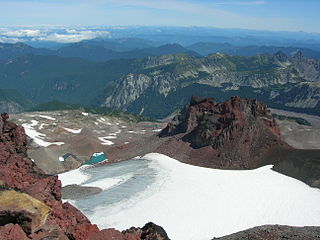
Fryingpan Glacier is on the eastern face of the 11,138-foot (3,395 m) Little Tahoma Peak, just to the east of Mount Rainier in the U.S. state of Washington. The glacier is located on top of a cliff from the Emmons Glacier to the north and a small ridge separates this glacier from the Whitman Glacier to the south, except for a small snowfield in which these two glaciers are connected. Most of the ice is located on a broad plateau at an elevation of 8,000 to 8,600 feet. The head of the Fryingpan Glacier is located to the northeast of the ridge and at the foothill of Little Tahoma Peak at around 9,100 to 9,800 feet. The glacier flows downhill eastward and the uneven topography causes the glacier surface to be crevassed The glacier ends on shallow to steep slopes at about 7,100 to 7,500 feet. Numerous snowfields and alpine meadows are located near the bottom and east of the glacier. Meltwater from the glacier drains into the White River.
Flett Glacier refers to two glaciers on the northwestern flank of Mount Rainier in the U.S. state of Washington. The glaciers lie on a subsidiary peak of Rainier, the 8,364 feet (2,549 m) Observation Rock. There are two sections of glacial ice, an eastern lobe at about 7,600 ft (2,300 m) to 7,300 ft (2,200 m) in elevation, a smaller western lobe at about 7,200 ft (2,200 m) in elevation. Meltwater from the glacier flows into the Puyallup River.
The Success Glacier is a small glacier located on the southwestern slopes of Mount Rainier in Washington. It covers 0.3 square miles (0.8 km2) and contains 500 million cubic ft of ice. The glacier is bounded to the northwest by the Success Cleaver and to the east by the Kautz Cleaver. Starting from a steep rocky slope at about 11,000 feet (3,400 m), the glacier flows southward downhill. At around 9,000 feet (2,700 m), a small snowfield joins this glacier with the Pyramid Glacier to the southwest. Soon after this point, the glacier joins the adjacent Kautz Glacier at 8,600 feet (2,600 m). The joined glaciers flow until their terminus at about 6,000 ft (1,800 m). Meltwater from the glacier drains into the Nisqually River.

Paradise Glacier is a glacier on the southeast flank of Mount Rainier in Washington. It covers 0.4 square miles (1.0 km2) and contains 0.8 billion ft3 with Stevens Glacier included. The glacier is bounded to the west by the Muir Snowfield, Anvil Rock and McClure Rock. There is a single extant main lobe of the glacier, ranging from 9,000 feet (2,700 m) to 7,200 feet (2,200 m), that is connected to the larger Cowlitz Glacier. To the south, there was a smaller portion which was near the Cowlitz Rocks and the tiny Williwakas Glacier, ranging from 6,900 feet (2,100 m) to 6,400 ft (2,000 m) in elevation and containing the Paradise Ice Caves until the 1990s. This smaller lobe melted between 2004 and 2006. Meltwater from the glacier drains into the Cowlitz River.

The Ohanapecosh Glacier is small glacier located on Mount Rainier's southeastern flanks in Washington. It covers 0.6 square miles (1.6 km2) and contains 1.3 billion ft3 of ice. The glacier consists of several lobes of ice interconnected by thin snowfields. Most of the glacier lies at an elevation of 8,300 feet (2,500 m) to 7,400 feet (2,300 m), near the Whitman and the Fryingpan Glacier. Since this ice lobe ends on a cliff, it contributes ice to the lower portions of the Ohanapecosh Glacier. The lower sections of this glacier end on cliffs and a small valley at about 6,100 ft (1,900 m) in elevation. Meltwater from the glacier drains into the Ohanapecosh River and the Muddy Fork Cowlitz River, which merge downstream about four miles (6 km) outside of Mount Rainier National Park into the Cowlitz River.

Emerald Lake is a small proglacial lake near the summit of Mount Timpanogos in the middle of the Mount Timpanogos Wilderness in the Wasatch Range in northeastern Utah County, Utah, United States.
Zigzag Glacier is an alpine glacier located on the upper southwest slopes of Mount Hood in the U.S. state of Oregon. It ranges in elevation from 10,200 to 7,200 feet with fingers in canyons extending to about 6,400 feet (2,000 m), and lies almost entirely within Mount Hood Wilderness. The upper extent is divided from Reid Glacier by Illumination Rock. The top of the glacier is at the foot of Crater Rock.

The Kankakee Outwash Plain is a flat plain interspersed with sand dunes in the Kankakee River valley in northwestern Indiana and northeastern Illinois of the United States. It is just south of the Valparaiso Moraine and was formed during the Wisconsin Glaciation. As the glacier stopped at the Valparaiso Moraine, its meltwater was carried away to the outwash plain. On the south side of the moraine, where the elevation drops, the meltwaters eroded away valleys, carrying sand and mud with them. As the muddy meltwater reached the valley where the slope lessened, the water slowed, depositing the sand on the outwash plain. This created a smooth, flat, and sandy plain. Before its draining, the Kankakee Marsh, located on the outwash plain, was one of the largest freshwater marshes in the United States.
Gordon Glacier is an Antarctic glacier of at least 24 nautical miles in length flowing in a northerly direction beginning in the Crossover Pass, flowing through the Shackleton Range to finally meet the Slessor Glacier.
Benson Glacier is in the U.S. state of Oregon. The glacier is situated in the Wallowa Mountains at an elevation generally above 8,500 feet (2,600 m) on the eastern slopes Glacier Peak, a subpeak of Eagle Cap. The glacier was named in honor of Frank W. Benson, former Governor of Oregon during an expedition in 1914. Benson Glacier is estimated to be 560 ft (170 m) long. Due to its small size, researchers have frequently questioned whether it was a glacier or a perennial snowfield. Areal photography taken in 2007 showed crevasses on the surface, confirming that it does flow and is a true glacier. It is not expected to remain a true glacier much longer, however, due to climate change.

Hinman Glacier was a glacier that flowed to the north and northwest from near the summit of Mount Hinman, in the U.S. state of Washington. Hinman Glacier was within the Alpine Lakes Wilderness of Snoqualmie National Forest. The glacier was approximately 1.3 km2 in 1971, making it the largest glacier between Mount Rainier and Glacier Peak, but an expedition by glaciologists from Nichols College in August 2022 discovered that the glacier had disappeared, with only a few snowfields and non-flowing remnant ice areas totalling 0.04 km2 remaining. Smaller glaciers in this part of the Cascade Range preceded the Hinman Glacier in disappearing as part of the retreat of glaciers since 1850 with only three glaciers remaining in King County.

Lake Kankakee formed 14,000 years before present (YBP) in the valley of the Kankakee River. It developed from the outwash of the Michigan Lobe, Saginaw Lobe, and the Huron-Erie Lobe of the Wisconsin glaciation. These three ice sheets formed a basin across Northwestern Indiana. It was a time when the glaciers were receding, but had stopped for a thousand years in these locations. The lake drained about 13,000 YBP, until reaching the level of the Momence Ledge. The outcropping of limestone created an artificial base level, holding water throughout the upper basin, creating the Grand Kankakee Marsh.


