Tintah, Minnesota

Last updated
Tintah
Traverse County Minnesota Incorporated and Unincorporated areas Tintah Highlighted.svg
Location of Tintah, Minnesota
Coordinates: 46°0′37″N96°19′18″W / 46.01028°N 96.32167°W / 46.01028; -96.32167
CountryUnited States
State Minnesota
County Traverse
Area
[1]
  Total0.75 sq mi (1.95 km2)
  Land0.75 sq mi (1.95 km2)
  Water0.00 sq mi (0.00 km2)
Elevation
1,001 ft (305 m)
Population
 (2020) [2]
  Total67
  Estimate 
(2021) [3]
65
  Density89.10/sq mi (34.41/km2)
Time zone UTC-6 (CST)
  Summer (DST) UTC-5 (CDT)
ZIP code
56583
Area code 218
FIPS code 27-64948 [4]
GNIS feature ID0653215 [5]

Tintah is a city in Traverse County, Minnesota, United States. The population was 67 at the 2020 census. [2]

Contents

Geography

According to the United States Census Bureau, the city has a total area of 0.76 square miles (1.97 km2), all land. [6]

Minnesota State Highway 9 serves as a main route in the community, and Minnesota State Highway 55 is nearby.

Demographics

Historical population
CensusPop.
1900 220
1910 217−1.4%
1920 24914.7%
1930 192−22.9%
1940 2004.2%
1950 23517.5%
1960 228−3.0%
1970 167−26.8%
1980 119−28.7%
1990 74−37.8%
2000 796.8%
2010 63−20.3%
2020 676.3%
2021 (est.)65 [3] −3.0%
U.S. Decennial Census [7]
2020 Census [2]

2010 census

As of the census of 2010, there were 63 people, 29 households, and 17 families residing in the city. The population density was 82.9 inhabitants per square mile (32.0/km2). There were 34 housing units at an average density of 44.7 per square mile (17.3/km2). The racial makeup of the city was 98.4% White and 1.6% from two or more races.

There were 29 households, of which 24.1% had children under the age of 18 living with them, 37.9% were married couples living together, 13.8% had a female householder with no husband present, 6.9% had a male householder with no wife present, and 41.4% were non-families. 41.4% of all households were made up of individuals, and 24.1% had someone living alone who was 65 years of age or older. The average household size was 2.17 and the average family size was 2.82.

The median age in the city was 44.3 years. 27% of residents were under the age of 18; 6.2% were between the ages of 18 and 24; 19.1% were from 25 to 44; 23.8% were from 45 to 64; and 23.8% were 65 years of age or older. The gender makeup of the city was 57.1% male and 42.9% female.

2000 census

As of the census of 2000, there were 79 people, 37 households, and 21 families residing in the city. The population density was 104.7 inhabitants per square mile (40.4/km2). There were 45 housing units at an average density of 59.6 per square mile (23.0/km2). The racial makeup of the city was 100.00% White.

There were 37 households, out of which 24.3% had children under the age of 18 living with them, 43.2% were married couples living together, 10.8% had a female householder with no husband present, and 43.2% were non-families. 40.5% of all households were made up of individuals, and 27.0% had someone living alone who was 65 years of age or older. The average household size was 2.14 and the average family size was 2.86.

In the city, the population was spread out, with 26.6% under the age of 18, 5.1% from 18 to 24, 26.6% from 25 to 44, 12.7% from 45 to 64, and 29.1% who were 65 years of age or older. The median age was 40 years. For every 100 females, there were 92.7 males. For every 100 females age 18 and over, there were 87.1 males.

The median income for a household in the city was $15,500, and the median income for a family was $13,125. Males had a median income of $18,750 versus $0 for females. The per capita income for the city was $13,536. There were 36.8% of families and 23.4% of the population living below the poverty line, including no under eighteens and 26.1% of those over 64.

Related Research Articles

<span class="mw-page-title-main">West Crossett, Arkansas</span> CDP in Arkansas, United States

West Crossett is a census-designated place (CDP) in Ashley County, Arkansas, United States. Per the 2020 census, the population was 1,144.

<span class="mw-page-title-main">River Park, Florida</span> Census-designated place in Florida, United States

River Park is a census-designated place (CDP) in St. Lucie County, Florida, United States. The population was 5,222 at the 2010 census, at which time it was listed as Port St. Lucie-River Park. It is part of the Port St. Lucie Metropolitan Statistical Area.

<span class="mw-page-title-main">Glencoe, Florida</span> CDP in Florida, United States

Glencoe is a census-designated place (CDP) in Volusia County, Florida, United States. The population was 2,582 at the 2010 census.

<span class="mw-page-title-main">Molena, Georgia</span> City in Georgia, United States

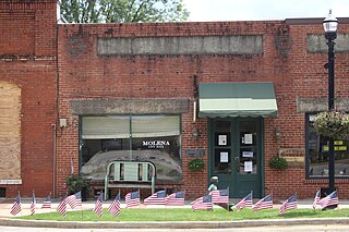
Molena is a city in Pike County, Georgia, United States. The population was 475 at the 2000 census.

<span class="mw-page-title-main">Webster, Iowa</span> City in Iowa, United States

Webster is a city in Keokuk County, Iowa, United States. The population was 94 at the time of the 2020 census.

<span class="mw-page-title-main">Fulton, Kansas</span> City in Kansas, United States

Fulton is a city in Bourbon County, Kansas, United States. As of the 2020 census, the population of the city was 165.

<span class="mw-page-title-main">Woodland Hills, Kentucky</span> City in Kentucky, United States

Woodland Hills is a home rule-class city in Jefferson County, Kentucky, United States. The population was 696 at the 2010 census.

<span class="mw-page-title-main">Watson, Minnesota</span> City in Minnesota, United States

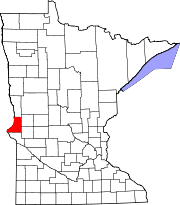
Watson is a city in Chippewa County, Minnesota, United States. The population was 205 at the 2010 census. Lac Qui Parle State Park is nearby.

<span class="mw-page-title-main">Harmony, Minnesota</span> City in Minnesota, United States

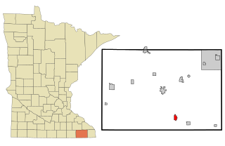
Harmony is a city in Fillmore County, Minnesota, United States. The population was 1,020 at the 2010 census. The town bills itself as the "Biggest Little Town in Southern Minnesota" and features the largest Amish community in the state.

<span class="mw-page-title-main">Madison, Minnesota</span> City in Minnesota, United States

Madison is a city in Lac qui Parle County, Minnesota, United States, along the 45th parallel. The population was 1,518 at the 2020 census. It is the county seat of Lac qui Parle County. It proclaims itself to be the "lutefisk capital of the USA."

<span class="mw-page-title-main">St. Rosa, Minnesota</span> City in Minnesota, United States

Saint Rosa is a city in Stearns County, Minnesota, United States. The population was 68 at the 2010 census. It is part of the St. Cloud Metropolitan Statistical Area.

<span class="mw-page-title-main">Gurley, Nebraska</span> Village in Nebraska, United States

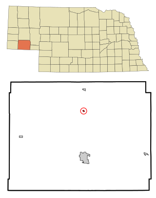
Gurley is a village in Cheyenne County, Nebraska, United States. The population was 214 at the 2010 census.

<span class="mw-page-title-main">Marquette, Nebraska</span> Village in Nebraska, United States

Marquette is a village in Hamilton County, Nebraska, United States. The population was 229 at the 2010 census.

<span class="mw-page-title-main">Hubbell, Nebraska</span> Village in Nebraska, United States

Hubbell is a village in Thayer County, Nebraska, United States. The population was 63 at the 2020 census.

<span class="mw-page-title-main">Bladen, Nebraska</span> Village in Nebraska, United States

Bladen is a village in Webster County, Nebraska, United States. The population was 237 at the 2010 census.

<span class="mw-page-title-main">Cuyamungue, New Mexico</span> Census-designated place in New Mexico, United States

Cuyamungue is a census-designated place (CDP) in Santa Fe County, New Mexico, United States. It is part of the Santa Fe, New Mexico Metropolitan Statistical Area. The population was 479 at the 2010 census.

<span class="mw-page-title-main">Adams Township, Butler County, Pennsylvania</span> Township in Pennsylvania, United States

Adams Township in Butler County, Pennsylvania, United States, is a township that had population of 11,652 at the 2010 census.

<span class="mw-page-title-main">Harrisville, Pennsylvania</span> Borough in Pennsylvania, United States

Harrisville is a borough in Butler County, Pennsylvania, United States. The population was 897 at the 2010 census.

<span class="mw-page-title-main">Millsap, Texas</span> Town in Texas, United States

Millsap is a town in Parker County, Texas, United States. Its population was 403 at the 2010 census.

<span class="mw-page-title-main">Nutter Fort, West Virginia</span> Town in West Virginia, United States

Nutter Fort is a town in Harrison County, West Virginia, United States, incorporated in 1923. The town is a southeastern suburb of Clarksburg. Since 1996, Nutter Fort has held the West Virginia Blackberry Festival during the first weekend of August. The population was 1,497 at the 2020 census. The town is also home to the Harrison County Sheriffs Department and the Harrison County Bureau of Emergency Services.

References

  1. "2020 U.S. Gazetteer Files". United States Census Bureau. Retrieved July 24, 2022.
  2. 1 2 3 "Explore Census Data". United States Census Bureau . Retrieved May 1, 2022.
  3. 1 2 "City and Town Population Totals: 2020-2021". United States Census Bureau. June 24, 2022. Retrieved June 24, 2022.
  4. "U.S. Census website". United States Census Bureau . Retrieved January 31, 2008.
  5. "US Board on Geographic Names". United States Geological Survey. October 25, 2007. Retrieved January 31, 2008.
  6. "US Gazetteer files 2010". United States Census Bureau. Archived from the original on January 25, 2012. Retrieved November 13, 2012.
  7. "Census of Population and Housing". Census.gov. Retrieved June 4, 2015.

Coordinates: 46°00′35″N96°19′21″W / 46.00972°N 96.32250°W / 46.00972; -96.32250