Staffordshire is a landlocked ceremonial county in the West Midlands of England. It borders Cheshire to the north-west, Derbyshire and Leicestershire to the east, Warwickshire to the south-east, the West Midlands county and Worcestershire to the south, and Shropshire to the west. The largest settlement is the city of Stoke-on-Trent, and the county town is Stafford.

Leek is a market town and civil parish in Staffordshire, England, on the River Churnet 10 miles (16 km) north east of Stoke-on-Trent. It is an ancient borough and was granted its royal charter in 1214.

James Brindley was an English engineer. He was born in Tunstead, Derbyshire, and lived much of his life in Leek, Staffordshire, becoming one of the most notable engineers of the 18th Century.

The Derwent is a river in Derbyshire, England. It is 50 miles (80 km) long and is a tributary of the River Trent, which it joins south of Derby. Throughout its course, the river mostly flows through the Peak District and its foothills.

The Trent is the third longest river in the United Kingdom. Its source is in Staffordshire, on the southern edge of Biddulph Moor. It flows through and drains the North Midlands into the Humber Estuary. The river is known for dramatic flooding after storms and spring snowmelt, which in the past often caused the river to change course.

The River Churnet is a river in Staffordshire, England. It is a tributary of the River Dove.

Severn Trent plc is a water company based in Coventry, England. It supplies 4.6 million households and business across the Midlands and Wales.
Staffordshire Moorlands is a local government district in Staffordshire, England. Its council is based in Leek, the district's largest town. The district also contains the towns of Biddulph and Cheadle, along with a large rural area containing many villages. North-eastern parts of the district lie within the Peak District National Park.

Caldon Canal is a branch of the Trent and Mersey Canal which opened in 1779. It runs 18 miles (29 km) from Etruria, Stoke-on-Trent, to Froghall, Staffordshire. The canal has 17 locks and the 76-yard (69 m) Froghall Tunnel.

The River Dove is the principal river of the southwestern Peak District, in the Midlands of England, and is around 45 miles (72 km) in length. It rises on Axe Edge Moor near Buxton and flows generally south to its confluence with the River Trent at Newton Solney. From there, its waters reach the North Sea via the Humber Estuary. For almost its entire course it forms the boundary between the counties of Staffordshire and Derbyshire. The river meanders past Longnor and Hartington and cuts through a set of deep limestone gorges, Beresford Dale, Wolfscote Dale, Milldale and Dovedale.

The Churnet Valley Railway is a preserved standard gauge heritage railway in the Staffordshire Moorlands of Staffordshire, England. It operates on part of the former Churnet Valley Line which was opened by the North Staffordshire Railway. The railway is roughly 10.5 miles (16.9 km) long from Kingsley and Froghall to Ipstones. The land from Leek Brook Junction to Ipstones was opened by Moorland & City Railways (MCR) in 2010 after they took a lease out from Network Rail. This has subsequently been purchased by the Churnet Valley Railway. The main stations along the line are Kingsley and Froghall, Consall, Cheddleton and Leek Brook. Work has begun to extend the line to the town of Leek which will act as the northern terminus of the line. The line between Leek and Waterhouses has also been reopened as part of the heritage railway as far as Ipstones.

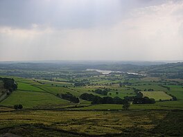
Rudyard Lake is a reservoir in Rudyard, Staffordshire, located north-west of the town of Leek, Staffordshire. It was constructed in the late 18th century to feed the Caldon Canal. During the 19th century, it was a popular destination for daytrippers taking advantage of easy access using the newly constructed North Staffordshire Railway. The lake is still used for many water activities such as boating, canoeing, fishing and also for walks and recreational steam train trips.
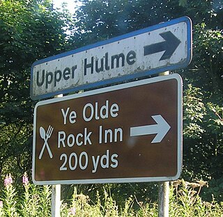
Upper Hulme is a hamlet in North Staffordshire, between the historic market town of Leek and the spa town of Buxton. It is clustered around a redundant mill and is located within the upper reaches of the River Churnet. The Mill was recently restored, with a working water wheel, but no further information on its future is known. It can be accessed by one of the many footpaths through the hamlet. The Peak District Boundary Walk runs through the village.

Dowdeswell Reservoir and former water treatment works lie below the parish of Dowdeswell in Gloucestershire. They were originally built by Cheltenham Corporation to supply the town of Cheltenham with drinking water and subsequently became part of the Severn Trent network.
Severn Trent Water Authority was one of ten regional water authorities established in 1974. Its area of operation was the catchments of the River Trent and River Severn. It assumed the powers and responsibilities of existing water supply authorities in those catchment areas, the Severn River Authority, the Trent River Authority and the sewage and sewage disposal responsibilities of the councils within its area.
The Churnet Valley line was one of the three original routes planned and built by the North Staffordshire Railway. Authorised in 1846, the line opened in 1849 and ran from North Rode in Cheshire to Uttoxeter in East Staffordshire. The line was closed in several stages between 1964 and 1988 but part of the central section passed into the hands of a preservation society and today operates as the Churnet Valley Railway.

The City of Nottingham Water Department (1912–1974), formerly the Nottingham Corporation Water Department (1880–1912), was responsible for the supply of water to Nottingham from 1880 to 1974. The first water supply company in the town was the Nottingham Waterworks Company, established in 1696, which took water from the River Leen, and later from springs at Scotholme, when the river became polluted. Other companies were set up in the late 18th century and in 1824, while in 1826 the Trent Water Company was established. They employed Thomas Hawksley as their engineer, who became one of the great water engineers of the period, and Nottingham had the first constant pressurised water supply system in the country. The various companies amalgamated in 1845, and Hawksley remained as the consulting engineer until 1879.

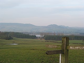
Meerbrook is a small village in North Staffordshire, on the River Churnet at the edge of the Peak District National Park. It is situated four miles north of the town of Leek, in the parish of Leekfrith. The Roaches and Hen Cloud, popular walking and climbing locations, are very nearby.
Tittesworth is a civil parish in the Staffordshire Moorlands, in Staffordshire, England. It extends from the edge of the town of Leek in the south-west to Blackshaw Moor in the north-east. In the east is the village of Thorncliffe. To the west is the civil parish of Leekfrith, where the boundary is the River Churnet.To the east is the civil parish of Onecote. Tittesworth Brook runs westwards through the area from Thorncliffe, and flows into the Churnet.

Deep Hayes Country Park is a country park in Staffordshire, England. It is about 3 miles (4.8 km) south-west of Leek, a short distance south of the A53 road at Longsdon.