Tlaxco Municipality, Tlaxcala

Last updated
Tlaxco
Panoramica de Tlaxco.jpg
The town and municipal seat of Tlaxco
EscudodeTlaxco.jpg
Mexico Tlaxcala Tlaxco location map.svg
Location in Tlaxcala
Mexico States blank map.svg
Red pog.svg
Tlaxco
Location in Mexico
Coordinates: 19°36′50″N98°07′07″W / 19.61389°N 98.11861°W / 19.61389; -98.11861 [1]
CountryFlag of Mexico.svg  Mexico
State Flag of Tlaxcala.svg  Tlaxcala
Established29 August 1945
SeatTlaxco
Government
[2]
  MayorArmando Flores López
Area
[1]
  Total575 km2 (222 sq mi)
Elevation
[1] (of seat)
2,553 m (8,376 ft)
Highest elevation
[3] (Cerro Peñas Coloradas)
3,360 m (11,020 ft)
Population
 (2010 Census) [4]
  Total39,939
  Estimate 
(2015 Intercensal Survey) [5]
42,536
  Density69/km2 (180/sq mi)
  Seat
14,806
Time zone UTC-6 (Central)
  Summer (DST) UTC-5 (Central)
Postal code of seat
90250
Area code 241
Website Official website

Tlaxco (Nahuatl: "place of the ball game" [6] ) is a municipality in the Mexican state of Tlaxcala in south-eastern Mexico.

Contents

Geography

The municipality of Tlaxco is located in northern Tlaxcala on the border with Hidalgo and Puebla. From east to west on its northern side, it borders the municipalities of Ixtacamaxtitlán and Chignahuapan in Puebla, and Almoloya and Apan in Hidalgo. From east to west on its southern side, it borders the Tlaxcalan municipalities of Emiliano Zapata, Lázaro Cárdenas, Tetla de la Solidaridad, Atlangatepec, Muñoz de Domingo Arenas, Hueyotlipan and Benito Juárez. [4] Tlaxco is Tlaxcala's largest municipality: it covers an area of 575 square kilometres (222 sq mi) and comprises 14.40% of the state's area. [1]

Situated in the Mexican Altiplano, Tlaxco lies at an average altitude of 2,540 metres (8,330 ft) above sea level. The western and central parts of the municipality are relatively flat, while the northern and eastern parts of the municipality feature more rugged terrain. [6] The highest point in the municipality is the Cerro Peñas Coloradas located at 19°39′55″N98°03′11″W / 19.6653°N 98.0531°W / 19.6653; -98.0531 with an elevation of 3,360 metres (11,020 ft) above sea level. [3] The Zahuapan River and its tributaries drain the central-eastern part of the municipality. [7] There are also two reservoirs in the municipality, Lázaro Cárdenas in the extreme east and El Muerto in the west. [6] [7] Agricultural land comprises 65.43% of the municipality. [7] Soils in the municipality include cambisols, fluvisols, lithosols, gleysols and andosols. [6]

Tlaxco's climate is temperate sub-humid with the warmest months being March through May. June through September are the months with the most rain. [6] Average annual precipitation ranges between 600 and 900 millimetres. [7]

Climate data for Tlaxco weather station at 19°35′33″N98°07′32″W / 19.59250°N 98.12556°W / 19.59250; -98.12556 , 2489 m above sea level (1951–2010)
MonthJanFebMarAprMayJunJulAugSepOctNovDecYear
Record high °C (°F)30.0
(86.0)
33.0
(91.4)
34.0
(93.2)
36.0
(96.8)
37.5
(99.5)
40.0
(104.0)
30.0
(86.0)
30.0
(86.0)
29.0
(84.2)
30.5
(86.9)
30.0
(86.0)
41.0
(105.8)
41.0
(105.8)
Average high °C (°F)22.0
(71.6)
23.4
(74.1)
25.6
(78.1)
26.4
(79.5)
25.8
(78.4)
23.6
(74.5)
22.6
(72.7)
22.8
(73.0)
22.0
(71.6)
22.0
(71.6)
22.3
(72.1)
21.8
(71.2)
23.4
(74.1)
Daily mean °C (°F)11.7
(53.1)
12.8
(55.0)
14.9
(58.8)
16.3
(61.3)
16.5
(61.7)
16.1
(61.0)
15.0
(59.0)
15.0
(59.0)
14.9
(58.8)
14.0
(57.2)
12.9
(55.2)
11.9
(53.4)
14.3
(57.7)
Average low °C (°F)1.5
(34.7)
2.3
(36.1)
4.3
(39.7)
6.1
(43.0)
7.3
(45.1)
8.5
(47.3)
7.4
(45.3)
7.2
(45.0)
7.8
(46.0)
5.9
(42.6)
3.5
(38.3)
2.1
(35.8)
5.3
(41.5)
Record low °C (°F)−9.0
(15.8)
−9.0
(15.8)
−6.0
(21.2)
−6.0
(21.2)
−2.0
(28.4)
−1.0
(30.2)
0.0
(32.0)
0.0
(32.0)
−3.5
(25.7)
−8.0
(17.6)
−9.0
(15.8)
−8.0
(17.6)
−9.0
(15.8)
Average precipitation mm (inches)11.8
(0.46)
8.9
(0.35)
13.8
(0.54)
41.6
(1.64)
72.0
(2.83)
127.4
(5.02)
124.2
(4.89)
120.9
(4.76)
110.2
(4.34)
60.1
(2.37)
15.0
(0.59)
6.7
(0.26)
712.6
(28.06)
Average precipitation days (≥ 0.1 mm)1.82.23.37.511.114.616.216.014.58.03.31.8100.3
Source: Servicio Meteorológico Nacional [8]

History

Although minor settlements have been found in the Tlaxco area dating back to the Texoloc phase or Middle Formative period, sedentary settlement of the area properly began in the Tezoquipan phase or Late Formative period by proto-Teotihuacan peoples who share elements of the Tezoquipan culture. From 650 to 850 AD, northern Tlaxcala experienced a period of political instability known as the Acopinalco Complex, during which many different cultural groups competed for control over the area. By 900 AD a group of Huastec or Otomi people had prevailed, and subsequent cultural homogenization resulted in formation of the Tlaxco culture which would later become associated with the city of Tliliuhquitepec. [6]

Franciscans had arrived in Tlaxco by 1614, which was then part of the municipality of Atlangatepec. After 1820 Tlaxco began to exist as a separate administrative division of Tlaxcala, with only minor interruptions. By the end of the 19th century, Tlaxco had become an important centre for the production of pulque. Porfirio Díaz visited Tlaxco in January 1894 and inaugurated the municipal palace. The modern municipality of Tlaxco was established on 29 August 1945 with the publication of the Organic Law of Municipalities in the State of Tlaxcala. In 1956 a highway linking Apizaco and Chignahuapan via Tlaxco was completed. [6]

Administration

The municipal government comprises a president, a councillor (Spanish: síndico), and seven trustees (regidores) elected by proportional representation. [6] The current president of the municipality is Gardenia Hernández Rodríguez. [2]

Demographics

In the 2010 Mexican Census, the municipality of Tlaxco recorded a population of 39,939 inhabitants living in 9356 households. [9] It recorded a population of 42,536 inhabitants in the 2015 Intercensal Survey. [5]

There are 155 localities in the municipality, [1] two of which are classified as urban:

Economy

The main economic activity in Tlaxco is agriculture. [6] The gross domestic product of the municipality was unofficially estimated at 1176.1 million Mexican pesos in 2010. [11]

Related Research Articles

<span class="mw-page-title-main">Municipalities of Tlaxcala</span>

Tlaxcala is a state in Central Mexico that is divided into 60 municipalities. According to the 2020 Mexican Census, it is the fifth least populated state with 1,342,977 inhabitants and the 2nd smallest by land area spanning 3,996.6 square kilometres (1,543.1 sq mi).

<span class="mw-page-title-main">Municipalities of Hidalgo</span>

Hidalgo is a state in central Mexico divided into 84 municipalities. According to the 2020 Mexican Census, Hidalgo is the 16th most populous state with 3,082,841 inhabitants and the 26th largest by land area spanning 20,813 square kilometres (8,036 sq mi).

<span class="mw-page-title-main">Jose Maria Morelos Buenavista</span> Locality in Tlaxcala, Mexico

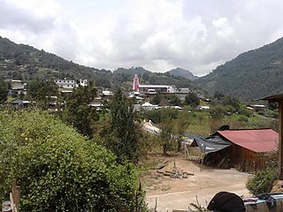
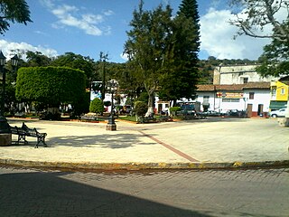
José María Morelos Buenavista or simply called Buenavista, is a town situated in the northwest of the State of Tlaxcala in the Mexican Republic, located in the municipality of Tlaxco. According to the INEGI in the census of the 2010 its population was 1,762 inhabitants. Its main economic activities are agriculture and cattle herding.

<span class="mw-page-title-main">Huehuetla, Puebla</span> Municipality in Puebla, Mexico

Huehuetla is a rural municipality in Puebla, Mexico.

<span class="mw-page-title-main">Río Grande Municipality, Zacatecas</span> Municipality in Zacatecas, Mexico

Río Grande is a municipality in the Mexican state of Zacatecas.

Las Minas is a municipality in the Mexican state of Veracruz, located 28 kilometres (17 mi) northeast of the state capital Xalapa.

Naranjal is a municipality in the Mexican state of Veracruz, located 10 kilometres (6.2 mi) south of the city of Córdoba.

<span class="mw-page-title-main">Citlaltépetl, Veracruz</span> Municipality in Veracruz, Mexico

Citlaltépetl is a municipality in the Mexican state of Veracruz, located 223 kilometres (139 mi) northwest of the state capital of Xalapa and 99 kilometres (62 mi) south of the city of Tampico, Tamaulipas.

<span class="mw-page-title-main">Tomatlán, Veracruz</span> Municipality in Veracruz, Mexico

Tomatlán is a municipality in the Mexican state of Veracruz, located 58 kilometres (36 mi) south of the state capital of Xalapa.

<span class="mw-page-title-main">Xoxocotla, Veracruz</span> Municipality in Veracruz, Mexico

Xoxocotla is a municipality in the Mexican state of Veracruz, located 103 kilometres (64 mi) south of the state capital Xalapa.

<span class="mw-page-title-main">Zacualpan, Veracruz</span> Municipality in Veracruz, Mexico

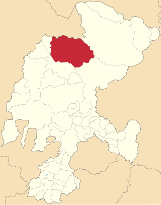
Zacualpan is a municipality in the Mexican state of Veracruz, located 179 kilometres (111 mi) northwest of the state capital of Xalapa and 56 kilometres (35 mi) northeast of the city of Pachuca, Hidalgo.

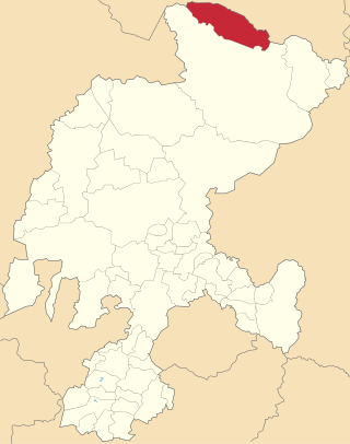
Zaragoza is a municipality in the Mexican state of Veracruz, located 297 kilometres (185 mi) southeast of the state capital of Xalapa and 10 kilometres (6.2 mi) southwest of the city of Minatitlán.

Carácuaro is a municipality in the Mexican state of Michoacán, located 77 kilometres (48 mi) south of the state capital of Morelia.

Cojumatlán de Régules is a municipality in the Mexican state of Michoacán, located 180 kilometres (110 mi) west of the state capital of Morelia.

<span class="mw-page-title-main">Huaniqueo</span> Municipality in Michoacán, Mexico

Huaniqueo is a municipality in the Mexican state of Michoacán, located approximately 40 kilometres (25 mi) northwest of the state capital of Morelia.

Nocupétaro is a municipality in the Mexican state of Michoacán, located approximately 75 kilometres (47 mi) south of the state capital of Morelia.

<span class="mw-page-title-main">Tzitzio</span> Municipality in Michoacán, Mexico

Tzitzio is a municipality in the Mexican state of Michoacán, located approximately 30 kilometres (19 mi) southeast of the state capital of Morelia.

<span class="mw-page-title-main">General Francisco R. Murguía Municipality</span> Municipality in Zacatecas, Mexico

General Francisco R. Murguía is a municipality in the Mexican state of Zacatecas, located approximately 140 kilometres (87 mi) north of the state capital of Zacatecas City.

<span class="mw-page-title-main">Miguel Auza Municipality</span> Municipality in Zacatecas, Mexico

Miguel Auza is a municipality in the Mexican state of Zacatecas, located approximately 190 kilometres (120 mi) northwest of the state capital of Zacatecas City.

<span class="mw-page-title-main">Melchor Ocampo Municipality, Zacatecas</span> Municipality in Zacatecas, Mexico

Melchor Ocampo is a municipality in the Mexican state of Zacatecas, located approximately 250 kilometres (160 mi) north of Zacatecas City, the state capital. It is named after Melchor Ocampo.

References

  1. 1 2 3 4 5 "Sistema Nacional de Información Municipal" (in Spanish). SEGOB. 2010. Retrieved 17 November 2017.
  2. 1 2 "H. Ayuntamiento de Tlaxco 2017-2021". Government of Tlaxco. Retrieved 17 November 2017.
  3. 1 2 "Cuaderno Estadística Municipal, Edicíon 1999: Tlaxco, Estado de Tlaxcala" (PDF) (in Spanish). INEGI. 2000. p. 4. Retrieved 17 November 2017.
  4. 1 2 3 4 "Tlaxco: Datos generales". Cédulas de información municipal (in Spanish). SEDESOL. 2013. Retrieved 17 November 2017.
  5. 1 2 Panorama sociodemográfico de Tlaxcala 2015 (PDF). INEGI. 2016. p. 116. ISBN   978-607-739-870-7 . Retrieved 17 November 2017.
  6. 1 2 3 4 5 6 7 8 9 "Tlaxco". Enciclopedia de los Municipios y Delegaciones de México (in Spanish). INAFED . Retrieved 17 November 2017.
  7. 1 2 3 4 "Compendio de Información Geográfica Municipal 2010: Tlaxco, Tlaxcala". INEGI . Retrieved 17 November 2017.
  8. "NORMALES CLIMATOLÓGICAS" (in Spanish). Servicio Meteorológico Nacional . Retrieved 17 November 2017.
  9. "Resumen municipal: Municipio de Tlaxco". Catálogo de Localidades (in Spanish). SEDESOL . Retrieved 17 November 2017.
  10. "Tlaxco, Tlaxcala". SECTUR. 16 March 2016. Retrieved 17 November 2017.
  11. González-Estrada, Adrián; Gallegos-Cedillo, Gilberto (2014). "The gross domestic product of municipalities of Mexico: II. Estates M-Z" (PDF). Revista Mexicana de Ciencias Agrícolas. 5 (8): 1405–1421. Retrieved 17 November 2017.