Castleton is a village in the High Peak district of Derbyshire, England, at the western end of the Hope Valley on the Peakshole Water, a tributary of the River Noe, between the Dark Peak to the north and the White Peak to the south. The population was 642 at the 2011 Census.

As of February 2001, there were 1,124 listed buildings with Grade II status in the English city of Brighton and Hove. The total at 2009 was similar. The city, on the English Channel coast approximately 52 miles (84 km) south of London, was formed as a unitary authority in 1997 by the merger of the neighbouring towns of Brighton and Hove. Queen Elizabeth II granted city status in 2000.

As of February 2001, there were 1,124 listed buildings with Grade II status in the English city of Brighton and Hove. The total at 2009 was similar. The city, on the English Channel coast approximately 52 miles (84 km) south of London, was formed as a unitary authority in 1997 by the merger of the neighbouring towns of Brighton and Hove. Queen Elizabeth II granted city status in 2000.

As of February 2001, there were 1,124 listed buildings with Grade II status in the English city of Brighton and Hove. The total at 2009 was similar. The city, on the English Channel coast approximately 52 miles (84 km) south of London, was formed as a unitary authority in 1997 by the merger of the neighbouring towns of Brighton and Hove. Queen Elizabeth II granted city status in 2000.

As of February 2001, there were 1,124 listed buildings with Grade II status in the English city of Brighton and Hove. The total at 2009 was similar. The city, on the English Channel coast approximately 52 miles (84 km) south of London, was formed as a unitary authority in 1997 by the merger of the neighbouring towns of Brighton and Hove. Queen Elizabeth II granted city status in 2000.

As of February 2001, there were 1,124 listed buildings with Grade II status in the English city of Brighton and Hove. The total at 2009 was similar. The city, on the English Channel coast approximately 52 miles (84 km) south of London, was formed as a unitary authority in 1997 by the merger of the neighbouring towns of Brighton and Hove. Queen Elizabeth II granted city status in 2000.

As of February 2001, there were 1,124 listed buildings with Grade II status in the English city of Brighton and Hove. The total at 2009 was similar. The city, on the English Channel coast approximately 52 miles (84 km) south of London, was formed as a unitary authority in 1997 by the merger of the neighbouring towns of Brighton and Hove. Queen Elizabeth II granted city status in 2000.
Bakewell is a civil parish in the Derbyshire Dales district of Derbyshire, England. The parish contains over 180 listed buildings that are recorded in the National Heritage List for England. Of these, six are listed at Grade I, the highest of the three grades, three are at Grade II*, the middle grade, and the others are at Grade II, the lowest grade. The parish contains the market town of Bakewell and the surrounding area. Most of the listed buildings are houses, cottages and associated structures, shops, offices, banks, and civic buildings. The other listed buildings include churches, two medieval cross bases in a churchyard, bridges, former almshouses, a guide stone, a milestone, former corn mills, public houses, a stile, a sheepwash enclosure, a former workhouse, now a hospital, with associated buildings, a railway station, a drinking fountain, a war memorial, and two telephone kiosks.
Bonsall is a civil parish in the Derbyshire Dales district of Derbyshire, England. The parish contains 13 listed buildings that are recorded in the National Heritage List for England. Of these, two are listed at Grade II*, the middle of the three grades, and the others are at Grade II, the lowest grade. The parish contains the village of Bonsall and the surrounding area. The listed buildings consist of houses, cottages and associated structures, a farmhouse and an outbuilding, a market cross, two churches, a public house, a sawmill converted for residential use, and a telephone kiosk.
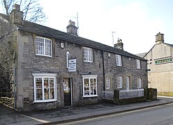
Castleton is a civil parish in the High Peak district of Derbyshire, England. The parish contains 25 listed buildings that are recorded in the National Heritage List for England. Of these, one is listed at Grade I, the highest of the three grades, one is at Grade II*, the middle grade, and the others are at Grade II, the lowest grade. The parish contains the village of Castleton and the surrounding countryside and moorland. The most important building in the parish is the ruined Peveril Castle, which is listed at Grade I. The other listed buildings include houses, cottages and associated structures, farmhouses and farm buildings, a church and a sundial in the churchyard, a hotel and a public house, a former watermill, three mileposts, a school, a war memorial, and a telephone kiosk.
Clifton and Compton is a civil parish in the Derbyshire Dales district of Derbyshire, England. The parish contains eight listed buildings that are recorded in the National Heritage List for England. Of these, one is listed at Grade II*, the middle of the three grades, and the others are at Grade II, the lowest grade. The parish contains the villages of Clifton and Hangingbridge, and the surrounding area. The listed buildings consist of houses, cottages and associated structures, a church, its lychgate and wall, a road bridge, and a public house.
Edensor is a civil parish in the Derbyshire Dales district of Derbyshire, England. The parish contains 50 listed buildings that are recorded on the National Heritage List for England. Of these, one is listed at Grade I, the highest of the three grades, six are at Grade II*, the middle grade, and the others are at Grade II, the lowest grade. The parish contains the model village of Edensor, which was created by Joseph Paxton for the 6th Duke of Devonshire, and the surrounding area. Most of the listed buildings are houses, cottages and associated structures, mainly within the village. The other listed buildings include a church, a cross and a tomb in the churchyard, a guidestone, a bridge, a former cotton mill, a hotel and a stable block converted for other uses, an ornamental fountain, a water trough, the wall and railings enclosing the village, and a telephone kiosk.
Hathersage is a civil parish in the Derbyshire Dales district of Derbyshire, England. The parish contains 54 listed buildings that are recorded in the National Heritage List for England. Of these, one is listed at Grade I, the highest of the three grades, three are at Grade II*, the middle grade, and the others are at Grade II, the lowest grade. The parish, which is almost entirely rural, contains the village of Hathersage and the surrounding countryside. Most of the listed buildings are farmhouses and farm buildings, houses, cottages, and associated structures. The other listed buildings include two churches, a cross shaft in a churchyard, a presbytery and a vicarage, two bridges, former mills, a milepost, a former toll house, a railway viaduct, and a lamp column.
Newton Solney is a civil parish in the South Derbyshire district of Derbyshire, England. The parish contains 19 listed buildings that are recorded in the National Heritage List for England. Of these, two are listed at Grade II*, the middle of the three grades, and the others are at Grade II, the lowest grade. The parish contains the village of Newton Solney and the surrounding area. Most of the listed buildings are houses, cottages and associated structures, farmhouses and farm buildings. The other listed buildings include a church, follies, a hotel and a public house, a row of almshouses, and part of a model farm.
Repton is a civil parish in the South Derbyshire district of Derbyshire, England. The parish contains 53 listed buildings that are recorded in the National Heritage List for England. Of these, six are listed at Grade I, the highest of the three grades, one is at Grade II*, the middle grade, and the others are at Grade II, the lowest grade. The parish contains the village of Repton, the smaller village of Milton, and the surrounding area. The major complex of buildings is associated with Repton School, built on the site of an earlier priory. Many of these are listed, four of them at Grade I. The other Grade I listed buildings are St Wystan's Church and the market cross. Most of the other listed buildings are houses, cottages and associated structures, the earlier ones timber framed, and the later ones in red brick. The rest of the listed buildings include farmhouses and farm buildings, bridges, a water management system, a war memorial, and a telephone, kiosk.
Stoney Middleton is a civil parish in the Derbyshire Dales district of Derbyshire, England. The parish contains 19 listed buildings that are recorded in the National Heritage List for England. Of these, one is listed at Grade II*, the middle of the three grades, and the others are at Grade II, the lowest grade. The parish contains the village of Stoney Middleton and the surrounding countryside. The listed buildings consist of houses, farmhouses, cottages and associated structures, a church and a tomb in the churchyard, a former malthouse, a bath house, a limekiln, a chapel, a milestone, a former toll house and a village cross.
Stretton is a civil parish in the North East Derbyshire district of Derbyshire, England. The parish contains eight listed buildings that are recorded in the National Heritage List for England. All the listed buildings are designated at Grade II, the lowest of the three grades, which is applied to "buildings of national importance and special interest". The parish contains the village of Stretton, smaller settlements including Woolley Moor, and the surrounding countryside. The listed buildings consist of farmhouses, farm buildings and associated structures, a dovecote, a former toll house, and a group of three bridges.
Wirksworth is a civil parish in the Derbyshire Dales district of Derbyshire, England. The parish contains 107 listed buildings that are recorded in the National Heritage List for England. Of these, one is listed at Grade I, the highest of the three grades, nine are at Grade II*, the middle grade, and the others are at Grade II, the lowest grade. The parish contains the market town of Wirksworth and the surrounding countryside. Most of the listed buildings are houses and associated structures, shops, farmhouses and farm buildings. The other listed buildings include a church and associated structures, public houses, a cotton spinning mill and associated structures, mileposts and milestones, a cemetery chapel, a railway bridge, groups of bollards, schools, a former engine house, a war memorial and a telephone kiosk.
Youlgreave is a civil parish in the Derbyshire Dales district of Derbyshire, England. The parish contains 57 listed buildings that are recorded in the National Heritage List for England. Of these, one is listed at Grade I, the highest of the three grades, one is at Grade II*, the middle grade, and the others are at Grade II, the lowest grade. The parish contains the village of Youlgreave, the hamlet of Alport and the surrounding countryside. Most of the listed buildings are houses, cottages and associated structures, farmhouses and farm buildings. The other listed buildings include a church and associated structures, a public house, bridges, a milestone, a conduit head, a school, a youth hostel and a telephone kiosk.
Alvaston is an electoral ward in the city of Derby, England. The ward contains 14 listed buildings that are recorded in the National Heritage List for England. Of these, three are listed at Grade II*, the middle of the three grades, and the others are at Grade II, the lowest grade. The ward was initially a village, and it has grown to become a suburb of the city. Towards the north of the ward are the former Tri Junct Station and the Derby Railway Works, and associated with them are four listed buildings. Some of the oldest listed buildings, consisting of cottages and a farmhouse, are located near the original centre of the village. The other listed buildings include churches and associated structures, a former toll house, and a conference centre.