Tolna, North Dakota

Last updated
Tolna, North Dakota
Fire Department building in Tolna, North Dakota 5-31-2009.jpg
Fire Department building in Tolna
ND Nelson County Tolna.svg
Location of Tolna, North Dakota
Coordinates: 47°49′36″N98°26′21″W / 47.82667°N 98.43917°W / 47.82667; -98.43917 Coordinates: 47°49′36″N98°26′21″W / 47.82667°N 98.43917°W / 47.82667; -98.43917
CountryUnited States
State North Dakota
County Nelson
Founded1906
Area
[1]
  Total0.75 sq mi (1.95 km2)
  Land0.75 sq mi (1.95 km2)
  Water0.00 sq mi (0.00 km2)
Elevation
1,467 ft (447 m)
Population
 (2020)
  Total136
  Density180.85/sq mi (69.79/km2)
Time zone UTC-6 (CST)
  Summer (DST) UTC-5 (CDT)
ZIP code
58380
Area code 701
FIPS code 38-79180
GNIS feature ID1032497 [2]
Website cityoftolna.com

Tolna is a city in Nelson County, North Dakota, United States. The population was 136 at the 2020 census. [3] Tolna was founded in 1906. In February 2019, resident Brian Nelson, who is an antique collector, was featured on "American Pickers" on the History Channel.

Contents

Geography

Tolna is located at 47°49′36″N98°26′21″W / 47.82667°N 98.43917°W / 47.82667; -98.43917 (47.826639, -98.439236). [4]

According to the United States Census Bureau, the city has a total area of 0.76 square miles (1.97 km2), all land. [5]

The Tolna Coulee is nearby and has been touted [ citation needed ]as a possible drainage path for the terminal lake Devils Lake that has been experiencing flooding since the mid-1990s.

Demographics

Historical population
CensusPop.
1910 209
1920 199−4.8%
1930 174−12.6%
1940 172−1.1%
1950 28163.4%
1960 2913.6%
1970 247−15.1%
1980 241−2.4%
1990 230−4.6%
2000 202−12.2%
2010 166−17.8%
2020 136−18.1%
2021 (est.)138 [6] 1.5%
U.S. Decennial Census [7]
2020 Census [3]

2010 census

As of the census of 2010, there were 166 people, 93 households, and 49 families residing in the city. The population density was 218.4 inhabitants per square mile (84.3/km2). There were 109 housing units at an average density of 143.4 per square mile (55.4/km2). The racial makeup of the city was 97.0% White, 1.8% Native American, and 1.2% from two or more races.

There were 93 households, of which 15.1% had children under the age of 18 living with them, 46.2% were married couples living together, 4.3% had a female householder with no husband present, 2.2% had a male householder with no wife present, and 47.3% were non-families. 44.1% of all households were made up of individuals, and 23.6% had someone living alone who was 65 years of age or older. The average household size was 1.78 and the average family size was 2.43.

The median age in the city was 56.3 years. 12.7% of residents were under the age of 18; 3.5% were between the ages of 18 and 24; 15% were from 25 to 44; 39.6% were from 45 to 64; and 28.9% were 65 years of age or older. The gender makeup of the city was 50.6% male and 49.4% female.

2000 census

As of the census of 2000, there were 202 people, 104 households, and 50 families residing in the city. The population density was 260.8 people per square mile (101.3/km2). There were 118 housing units at an average density of 152.3 per square mile (59.2/km2). The racial makeup of the city was 99.01% White, 0.50% Native American, and 0.50% from two or more races.

There were 104 households, out of which 22.1% had children under the age of 18 living with them, 41.3% were married couples living together, 7.7% had a female householder with no husband present, and 51.0% were non-families. 47.1% of all households were made up of individuals, and 35.6% had someone living alone who was 65 years of age or older. The average household size was 1.94 and the average family size was 2.82.

In the city, the population was spread out, with 20.3% under the age of 18, 4.5% from 18 to 24, 20.8% from 25 to 44, 24.8% from 45 to 64, and 29.7% who were 65 years of age or older. The median age was 49 years. For every 100 females, there were 64.2 males. For every 100 females age 18 and over, there were 62.6 males.

The median income for a household in the city was $23,000, and the median income for a family was $45,000. Males had a median income of $31,250 versus $17,188 for females. The per capita income for the city was $18,430. None of the families and 11.3% of the population were living below the poverty line, including no under eighteens and 29.5% of those over 64.

Related Research Articles

<span class="mw-page-title-main">Wailea-Makena, Hawaii</span> Former CDP in Hawaii, United States

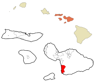
Wailea-Makena was a census-designated place (CDP) in Maui County, Hawaiʻi, United States, during the 2000 census, at which time its population was 5,671. The area was split into two CDPs, Wailea and Makena, for the 2010 census.

<span class="mw-page-title-main">Oakland Acres, Iowa</span> City in Iowa, United States

Oakland Acres is a city in Jasper County, Iowa, United States. The population was 176 at the time of the 2020 census.

<span class="mw-page-title-main">Osage City, Kansas</span> City in Osage County, Kansas

Osage City is a city in Osage County, Kansas, United States. As of the 2020 census, the population of the city was 2,861.

<span class="mw-page-title-main">Ogema, Minnesota</span> City in Minnesota, United States

Ogema is a city in Becker County, Minnesota, United States. The population was 208 at the 2020 census.

<span class="mw-page-title-main">Boy River, Minnesota</span> City in Minnesota, United States

Boy River is a city in Cass County, Minnesota, United States. The population was 47 at the 2010 census. It is part of the Brainerd Micropolitan Statistical Area.

<span class="mw-page-title-main">Coleraine, Minnesota</span> City in Minnesota, United States

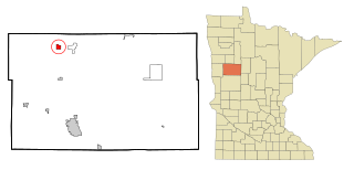
Coleraine is a city in Itasca County, Minnesota, United States. The population was 1,970 at the 2010 census. The community was named after Thomas F. Cole, President of the Oliver Iron Mining Company.

<span class="mw-page-title-main">Warba, Minnesota</span> City in Minnesota, United States

Warba is a city in Itasca County, Minnesota, United States. The population was 181 at the 2010 census.

<span class="mw-page-title-main">Wilder, Minnesota</span> City in Minnesota, United States

Wilder is a city in Jackson County, Minnesota, United States. The population was 60 at the 2010 census.

<span class="mw-page-title-main">Lake Henry, Minnesota</span> City in Minnesota, United States

Lake Henry is a city in Stearns County, Minnesota, United States. The population was 103 at the 2010 census. It is part of the St. Cloud Metropolitan Statistical Area.

<span class="mw-page-title-main">Clifton Hill, Missouri</span> City in Missouri, United States

Clifton Hill is a city in Randolph County, Missouri, United States. The population was 114 at the 2010 census.

<span class="mw-page-title-main">Fleming, Missouri</span> City in Missouri, United States

Fleming is a city in Ray County, Missouri, and part of the Kansas City metropolitan area within the United States. The population was 114 at the 2020 census.

<span class="mw-page-title-main">Federal Dam, Minnesota</span> City in Minnesota, United States

Federal Dam is a city in Cass County, Minnesota, United States, near Leech Lake. The population was 110 at the 2010 census. It is part of the Brainerd Micropolitan Statistical Area.

<span class="mw-page-title-main">Warwick, North Dakota</span> City in North Dakota, United States

Warwick is a city in Benson County, North Dakota, United States. The population was 55 at the 2020 census. Warwick was founded in 1907.

<span class="mw-page-title-main">Churchs Ferry, North Dakota</span> City in North Dakota, United States

Churchs Ferry is a city in Ramsey County, North Dakota, United States that has been impacted by the expansion of nearby Devils Lake. The population was 9 at the 2020 census. Churchs Ferry was founded in 1886.

<span class="mw-page-title-main">Lisbon, North Dakota</span> City in North Dakota, United States

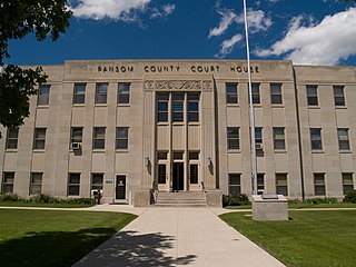
Lisbon is a city in Ransom County, North Dakota, United States. It is the county seat of Ransom County. The population was 2,204 at the 2020 census.

<span class="mw-page-title-main">Clifford, North Dakota</span> City in North Dakota, United States

Clifford is a city in Traill County, North Dakota, United States. The population was 44 at the 2010 census. Clifford was founded in 1883.

<span class="mw-page-title-main">Fordville, North Dakota</span> City in North Dakota, United States

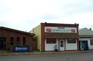
Fordville is a city in Walsh County, North Dakota, United States. The population was 207 at the 2020 census. Fordville was founded in 1905.

<span class="mw-page-title-main">Cameron, West Virginia</span> City in West Virginia

Cameron is a city in Marshall County, West Virginia, United States. It is part of the Wheeling, West Virginia metropolitan area. The population was 849 at the 2020 census.

<span class="mw-page-title-main">Brandonville, West Virginia</span> Town in West Virginia, United States

Brandonville is a town in Preston County, West Virginia, United States. The population was 136 at the 2020 census.

<span class="mw-page-title-main">Teton Village, Wyoming</span> CDP in Wyoming, United States

Teton Village is a census-designated place (CDP) in Teton County, Wyoming, United States. The population was 330 at the 2010 census. The village surrounds the base of the Jackson Hole Mountain Resort. It is accessed from nearby Jackson and the surrounding area via the Moose-Wilson Road.

References

  1. "ArcGIS REST Services Directory". United States Census Bureau. Retrieved September 20, 2022.
  2. "US Board on Geographic Names". United States Geological Survey. October 25, 2007. Retrieved January 31, 2008.
  3. 1 2 "Explore Census Data". United States Census Bureau . Retrieved May 14, 2022.
  4. "US Gazetteer files: 2010, 2000, and 1990". United States Census Bureau. February 12, 2011. Retrieved April 23, 2011.
  5. "US Gazetteer files 2010". United States Census Bureau. Archived from the original on July 2, 2012. Retrieved June 14, 2012.
  6. "City and Town Population Totals: 2020-2021". United States Census Bureau. July 17, 2022. Retrieved July 17, 2022.
  7. United States Census Bureau. "Census of Population and Housing" . Retrieved February 15, 2014.