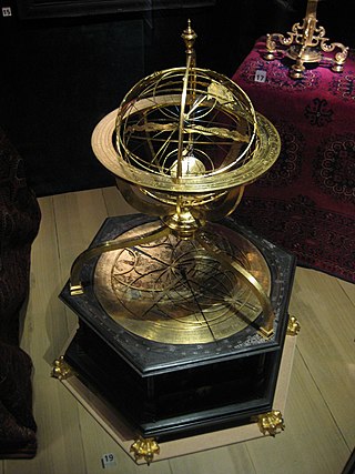
Torquetum (1568), made by Johannes Praetorius in Nuremberg.Engraving of a Torquetum
The torquetum or turquet is a medieval astronomical instrument designed to take and convert measurements made in three sets of coordinates: Horizon, equatorial, and ecliptic. It is said to be a combination of Ptolemy's astrolabon and the plane astrolabe.[1] In a sense, the torquetum is an analog computer.
The origins of the torquetum are unclear. Its invention has been credited to multiple figures, including Bernard of Verdun, Franco of Poland, and Jabir ibn Aflah.[2]
The earliest account of the torquetum appear in the writings of Bernard of Verdun[3] and Franco of Poland.[4][5] Franco of Poland's work was published in 1284; however, Bernard of Verdun's work does not contain a date. Therefore, it is impossible to know which work was written first. Franco's work was more widely known and is credited with the distribution of knowledge about the torquetum.[5]
Some authors have supposed that the first torquetum was built by Jabir ibn Aflah, though there is conflicting evidence that suggests that Jabir simply inspired the invention of the torquetum,[1] and little evidence exists to suggest that it was created by him.[5]
The instrument was first created sometime in the 12th or 13th century.[4] However, the only surviving examples of the torquetum are dated from the 16th century. In the middle of the 16th century, the torquetum had numerous structural changes to the original design.[6] The most important change was by instrument-maker, Erasmus Habermel. His alteration allowed for astronomers to make observations to all three of the scales.[6]
A torquetum can be seen in the famous portrait The Ambassadors (1533) by Hans Holbein the Younger. It is placed on the right side of the table, next to and above the elbow of the ambassador clad in a long brown coat or robe. The painting shows much of the details of the inscriptions on the disk and half disk, which make up the top of this particular kind of torquetum.[6]
A 14th century instrument, the rectangulus, was invented by Richard of Wallingford. This carried out the same task as the torquetum, but was calibrated with linear scales, read by plumb lines. This simplified the spherical trigonometry by resolving the polar measurements directly into their Cartesian components.
Notable historic uses
This is the first image that appears on Peter Apian's book Astronomicium Caesareum of 1540. Apian uses the torquetum to view the comet of 1532.
Following the conception of the torquetum, the device had been put through many of the following uses. The astronomer, Peter of Limoges, used this device for his observation of what is known today as Halley's Comet at the turn of the 14th century.[6] In the early 1300s, John of Murs mentions the torquetum as his defence "of the reliability of observational astronomy",[6] thus further solidifying its practicality and viability in ancient astronomy. Additionally, Johannes Schoner built a torquetum model for his own personal use in the observation of Halley's Comet in the 1500s.[6]
The best-documented account of the torquetum was done by Peter Apian in 1532. Peter Apian was a German humanist, specializing in astronomy, mathematics, and cartography. In his book Astronomicum Caesareum (1540), Apian gives a description of the torquetum near the end of the second part. He also details how the device is used. Apian explains that the torquetum was used for astronomical observations and how the description of the instrument was used as a basis for common astronomical instruments. He also notes the manufacturing process of the instrument and the use of the torquetum for astronomical measurements.[7]
Components
The torquetum is a complex medieval analog computer that measures three sets of astronomical coordinates: the horizon, equatorial, and ecliptic. One of the defining attributes of the torquetum is its ability to interconvert between these three sets of coordinate dimensions without the use of calculations, as well as to demonstrate the relationship between the same coordinate sets. However, it is a device that requires a thorough understanding of the components and how they work together to make relative positional measurements of certain celestial objects.
The anatomy of the torquetum involves many different components, which can be grouped into subdivisions of the torquetum structure, those being: the base, the midframe, and the upperframe. The base starts with the tabula orizontis, which is the bottommost rectangular piece in contact with the ground, and this component represents the horizon of the Earth, relative to the point of measurement. Hinged to the tabula orizontis is a similarly shaped component, the tabula quinoctialis, which represents the latitude of the Earth. This piece can rotate up to 90 degrees, coinciding with the latitudinal lines of the Earth from the equator to the poles. This angle of rotation is created by the stylus, which is an arm mechanism that pins to the slotted holes, which are part of the tabula orizontis.
The midframe of the torquetum consists of a free-spinning disk (unnamed) that can be locked into place, and the tabula orbis signorum, directly hinged to it above. The angle between these two pieces is defined by the basilica, a solid stand piece, which is used to either set the draft angle at 0 degrees (Where the basilica is removed) or 23.5 degrees, representing the off-set of the axis of rotation of the Earth. Whether or not the basilica is included depends on the point of measurement either below or above the tropical latitudinal lines. Inscribed on the tabula equinoctialis along, although separate from, the outer perimeter of the bottom disk is a 24-hour circle, which is used to measure the angle between the longitudinal line facing the poles, and the line to the object being measured.
Lastly, the upper frame is made up of the crista, the semis and the perpendiculum. The base of the crista is joined to another free-spinning disk directly above the tabula orbis signorum.
Similarly, on the outer edge of the tabula orbis signorum is a zodiacal calendar and degree scale, with each of the 12 signs divided amongst it. This scale measures the zodiacal sector of the sky the object being measured is in. The crista itself is a circular piece that corresponds with the meridian of the celestial sphere, which has four quadrants inscribed along the edges, each starting at 0 degrees along the horizontal, and 90 degrees along the vertical. Adjacent, and locked with the crista at 23.5 degrees angle is the semis, which is a half-circle composed of two quadrants starting at 0 degrees along the vertical (relative to 23.5-degree placement) and 90 degrees at the horizontal. Finally, the last major component is the perpendicular, a free-hanging pendulum which measures the angle between the radial line of the Earth and the measured object using the semis.
Parts and configurations
The base of the instrument represents the horizon and is built on a hinge and a part known as the stylus holds the instrument up to the viewer's complementary latitude. This represents the celestial equator and the angle varies depending on where the view is located on Earth. The several plates and circles that make up the upper portion of the instrument represent the celestial sphere. These parts are built on top of the base and above the basilica, which rotates on a pin to represent the axis of the Earth. The zodiac calendar is inscribed on the tabula orbis signorum this is part of the mechanical aspects of the instrument that take away the tedious calculations required in previous instruments.[8]
The versatility of the "torquetum" can be seen in its three possible configurations for the measuring. The first method used lays the instruments flat on a table with no angles within the instrument set. This configuration gives the coordinates of celestial bodies as related to the horizon. The basilica is set so that 0 degree mark faces north. The user can now measure altitude of the target celestial body as well as use the base as a compass for viewing the possible paths they travel. The second configuration uses the stylus to elevate the base set at co-latitude of 90 degrees. The position of the celestial bodies can now be measured in hours, minutes, and seconds using the inscribed clock on the almuri. This helps give the proper ascension and decline coordinates of the celestial bodies as they travel through space. The zero point for ascension and decline coordinates of the celestial bodies as they travel through space. The zero point for ascension is set to the vernal equinox while the end measurement (decline) is the equator, this would put the North Pole at the 90 degree point. The third and most commonly seen configuration of the "torquetum" uses all its assets to make measurements. The upper portion is now set at an angle equal to the obliquity of the ecliptic, which allows the instrument to give ecliptic coordinates. This measures the celestial bodies now on celestial latitude and longitude scales which allow for greater precision and accuracy in making measurements. These three differing configurations allowed for added convenience in taking readings and made once tedious and complicated measuring more streamlined and simple.
In astronomy, declination is one of the two angles that locate a point on the celestial sphere in the equatorial coordinate system, the other being hour angle. Declination's angle is measured north or south of the celestial equator, along the hour circle passing through the point in question.
The ecliptic or ecliptic plane is the orbital plane of Earth around the Sun. From the perspective of an observer on Earth, the Sun's movement around the celestial sphere over the course of a year traces out a path along the ecliptic against the background of stars. The ecliptic is an important reference plane and is the basis of the ecliptic coordinate system.
A solar equinox is a moment in time when the Sun crosses the Earth's equator, which is to say, appears directly above the equator, rather than north or south of the equator. On the day of the equinox, the Sun appears to rise "due east" and set "due west". This occurs twice each year, around 20 March and 23 September.
Geodesy is the science of measuring and representing the geometry, gravity, and spatial orientation of the Earth in temporally varying 3D. It is called planetary geodesy when studying other astronomical bodies, such as planets or circumplanetary systems.
Right ascension is the angular distance of a particular point measured eastward along the celestial equator from the Sun at the March equinox to the point in question above the Earth. When paired with declination, these astronomical coordinates specify the location of a point on the celestial sphere in the equatorial coordinate system.
A sextant is a doubly reflecting navigation instrument that measures the angular distance between two visible objects. The primary use of a sextant is to measure the angle between an astronomical object and the horizon for the purposes of celestial navigation.
Astronomicalcoordinate systems are organized arrangements for specifying positions of satellites, planets, stars, galaxies, and other celestial objects relative to physical reference points available to a situated observer. Coordinate systems in astronomy can specify an object's position in three-dimensional space or plot merely its direction on a celestial sphere, if the object's distance is unknown or trivial.
The equatorial coordinate system is a celestial coordinate system widely used to specify the positions of celestial objects. It may be implemented in spherical or rectangular coordinates, both defined by an origin at the centre of Earth, a fundamental plane consisting of the projection of Earth's equator onto the celestial sphere, a primary direction towards the vernal equinox, and a right-handed convention.
The horizontal coordinate system is a celestial coordinate system that uses the observer's local horizon as the fundamental plane to define two angles: altitude and azimuth. Therefore, the horizontal coordinate system is sometimes called the az/el system, the alt/az system, or the alt-azimuth system, among others. In an altazimuth mount of a telescope, the instrument's two axes follow altitude and azimuth.
An astrolabe is an astronomical instrument dating back to ancient times. It serves as a star chart and physical model of visible heavenly bodies. Its various functions also make it an elaborate inclinometer and an analog calculation device capable of working out several kinds of problems in astronomy. In its simplest form it is a metal disc with a pattern of wires, cutouts, and perforations that allows a user to calculate astronomical positions precisely. Historically used by astronomers, it is able to measure the altitude above the horizon of a celestial body, day or night; it can be used to identify stars or planets, to determine local latitude given local time, to survey, or to triangulate. It was used in classical antiquity, the Islamic Golden Age, the European Middle Ages and the Age of Discovery for all these purposes.
Celestial navigation, also known as astronavigation, is the practice of position fixing using stars and other celestial bodies that enables a navigator to accurately determine their actual current physical position in space or on the surface of the Earth without relying solely on estimated positional calculations, commonly known as "dead reckoning." Celestial navigation is performed without using satellite navigation or other similar modern electronic or digital positioning means.
An armillary sphere is a model of objects in the sky, consisting of a spherical framework of rings, centered on Earth or the Sun, that represent lines of celestial longitude and latitude and other astronomically important features, such as the ecliptic. As such, it differs from a celestial globe, which is a smooth sphere whose principal purpose is to map the constellations. It was invented separately, in ancient China possibly as early as the 4th century BC and ancient Greece during the 3rd century BC, with later uses in the Islamic world and Medieval Europe.
In astrology, the Equatorial Ascendant, or the East Point, is the sign and degree rising over the Eastern Horizon at the Earth's equator at any given time. In the celestial sphere it corresponds to the intersection of the ecliptic with a great circle containing the celestial poles and the East point of the horizon.
Spherical astronomy, or positional astronomy, is a branch of observational astronomy used to locate astronomical objects on the celestial sphere, as seen at a particular date, time, and location on Earth. It relies on the mathematical methods of spherical trigonometry and the measurements of astrometry.
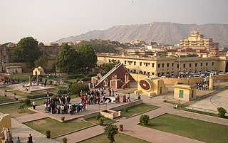
The Jantar Mantar, Jaipur is a collection of 19 astronomical instruments built by the Rajput king Sawai Jai Singh, the founder of Jaipur, Rajasthan. The monument was completed in 1734. It features the world's largest stone sundial, and is a UNESCO World Heritage Site. It is near City Palace and Hawa Mahal. The instruments allow the observation of astronomical positions with the naked eye. The observatory is an example of the Ptolemaic positional astronomy which was shared by many civilizations.
The navigational triangle or PZX triangle is a spherical triangle used in astronavigation to determine the observer's position on the globe. It is composed of three reference points on the celestial sphere:
In astronomy, sextants are devices depicting a sixth of a circle, used primarily for measuring the position of stars. There are two types of astronomical sextants, mural instruments and frame-based instruments.
A quadrant is an instrument used to measure angles up to 90°. Different versions of this instrument could be used to calculate various readings, such as longitude, latitude, and time of day. Its earliest recorded usage was in ancient India in Rigvedic times by Rishi Atri to observe a solar eclipse. It was then proposed by Ptolemy as a better kind of astrolabe. Several different variations of the instrument were later produced by medieval Muslim astronomers. Mural quadrants were important astronomical instruments in 18th-century European observatories, establishing a use for positional astronomy.
This glossary of astronomy is a list of definitions of terms and concepts relevant to astronomy and cosmology, their sub-disciplines, and related fields. Astronomy is concerned with the study of celestial objects and phenomena that originate outside the atmosphere of Earth. The field of astronomy features an extensive vocabulary and a significant amount of jargon.
The rectangulus was an astronomical instrument made by Richard of Wallingford around 1326. Dissatisfied with the limitations of existing astrolabes, Richard developed the rectangulus as an instrument for spherical trigonometry and to measure the angles between planets and other astronomical bodies. This was one of a number of instruments he created, including the Albion, a form of equatorium, and a famously complicated and expensive horologium.
This page is based on this Wikipedia article Text is available under the CC BY-SA 4.0 license; additional terms may apply. Images, videos and audio are available under their respective licenses.