This is a list of properties and districts in Massachusetts listed on the National Register of Historic Places. There are over 4,300 listings in the state, representing about 5% of all NRHP listings nationwide and the second-most of any U.S. state, behind only New York. Listings appear in all 14 Massachusetts counties.

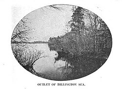
Town Brook is a 1.5-mile (2.4 km) stream in Plymouth, Massachusetts that provided drinking water to the Pilgrims who made their homes adjacent to the brook on Leyden Street in Plymouth. Town Brook's headwaters are the Billington Sea, a 269-acre (109 ha) freshwater pond. The brook passes through numerous small ponds, including Deep Water Pond and Jenny Pond. It also passes by the Plimoth Grist Mill and the Brewster Gardens before emptying into Plymouth Harbor. A nature trail runs along the entire length of the brook.
The Mansfield Hollow Historic District encompasses the remnants of a modest 19th-century industrial village on Mansfield Hollow Road in Mansfield, Connecticut. Originally industrialized with saw and grist mills, a silk mill was added in 1838, when its most significant growth began. The surviving stone mill was built in 1882, and there are a number of nearby houses dating to the industrial period. The district was listed on the National Register of Historic Places in 1979.
The South Coventry Historic District is a historic district encompassing the historic village center of South Coventry in the town of Coventry, Connecticut. The village, settled in the early 18th century, has served as Coventry's civic center, and also served as an economic center, with textile mills operating in the 19th century. The district was listed on the National Register of Historic Places in 1991.

The South Britain Historic District encompasses the core of the unincorporated village of South Britain in Southbury, Connecticut, United States. The village arose in the 18th century as an industrial center serving the surrounding agricultural community, powered by the Pomperaug River, and rivalled the town center of Southbury in importance. The district was listed on the National Register of Historic Places in 1987.

The South Glastonbury Historic District is a historic district in Glastonbury, Connecticut. It encompasses the historic village center of South Glastonbury, which was first settled in the 17th century. The district was listed on the National Register of Historic Places in 1984, and enlarged in 2009 to include properties further along Main Street as far as Chestnut Hill Road. Locals refer to it as Nayaug.

The Russells Mills Village Historic District is a historic district on Russells Mills, Rock O' Dundee, Slades Corner, Horseneck and Fisher Roads in Dartmouth, Massachusetts. It encompasses an area that was an early industrial center, flourishing from the 18th century into the early 19th century. The district was added to the National Register of Historic Places in 1985.

Sachem Rock Farm is a historic farm at 355 Plymouth Street in East Bridgewater, Massachusetts, United States. The farm location is important for a variety of reasons. Its earliest historical association is with the Wampanoag people, who are known to have used the area, particularly around Sachem Rock, a granite outcrop that is the property's high point, prior to European contact. Sachem Rock itself is historically significant as the site of a meeting in 1649 between English settlers from the Plymouth Colony, including Myles Standish, with the Wampanoag sachem Massasoit. In this meeting the colonists purchased rights to a large tract of land, including East and West Bridgewater, Bridgewater, and Brockton.

The West Whately Historic District is a historic district encompassing over 700 acres (280 ha) of western Whately, Massachusetts. The area, located in the foothills of The Berkshires above the Connecticut River, has a long agricultural history, but also experienced a surge of industrial activity in the 19th century, of which only fragments remain. The district, listed on the National Register of Historic Places in 2003, is focused on the areas surrounding West Brook and the areas where there was once industrial activity. From the late 18th century into the early 20th, there were some 16 mill complexes in the area, of which only one still has a surviving structure. The principal elements that survive of this industrial past are foundations and evidence of water works such as dams and millraces. There are only two institutional buildings in the district: the West Whately Chapel, built in the Queen Anne style in 1896, and a schoolhouse that has since been converted to a residence.
The Brookside Historic District of Westford, Massachusetts encompasses surviving elements of the 19th century Brookside mill village, the smallest of the town's three 19th-century industrial villages. Developed between about 1860 and 1904, it includes surviving mill buildings and a variety of mill-related worker housing. The district was listed on the National Register of Historic Places in 2003.

The Spot Pond Archeological District is a historic archaeological site near Spot Pond in Stoneham, Massachusetts. It is located in the Virginia Woods section of the Middlesex Fells Reservation, a state park. The district encompasses sites along Spot Pond Brook that were mill sites dating from the 17th to the 19th centuries. At its height, in the mid-19th century the Hayward Rubber Works was located in the area, giving it the name "Haywardville". One of the park's trails runs through the area, and a park pamphlet provide a self-guided tour joining the major remnants of the industries that once flourished there.

The East Jaffrey Historic District is a historic district running roughly along NH Route 124 through Jaffrey, New Hampshire. It encompasses what is now the economic and civic heart of the town, centered on the Jaffrey Mills and the crossing of the Contoocook River by Route 124. It extends as far west as St. Patrick's Church beyond Charlonne Street and as far east as the US Post Office building at Route 124 and Ellison Street. To the north it extends along Peterborough Street to Christian Court, and to the south it extends along River Street and School Street to their junction. The district includes early 19th-century residential structures, as well as industrial buildings and housing associated with the Jaffrey Mills which arose in the mid-19th century. The district was added to the National Register of Historic Places in 2002.

The West Chesterfield Historic District is a historic district that encompasses the 19th century industrial and residential heritage of the village of West Chesterfield in the town of Chesterfield, Massachusetts. Centered at the junction of Main Road and Ireland Street, it was one of the town's main industrial sites for many years. The district was listed on the National Register of Historic Places in 2008.

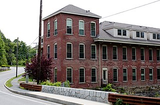
The Jaffrey Mills is a historic mill complex at 41 Main Street, in the central business district of Jaffrey, New Hampshire. It consists of a connected series of primarily brick buildings flanking the Contoocook River just north of Main Street. Its oldest buildings, the original mill and office building, are on the west side of the river. They were built in 1868, and feature mansard roofs and banded dentil brick cornices. The mill building has a tower that originally sported a cupola, but this was removed early in the 20th century. In 1872 the building on the east side was built, and the two sides joined by timber-frame bridges were added in 1897, at the same time the east building was extended northward. Later additions to the north of the east building include a storage area and a loading dock. The mill complex, the only 19th-century industrial complex of its type to be built in Jaffrey, was listed on the National Register of Historic Places in 1982. It has been converted into residences.

The Lochmere Archeological District is a large archeological area on the banks of the Winnipesaukee River in Belknap County, New Hampshire, near the village of Lochmere. The area, part of which is now preserved by the state as the Brennick Lochmere Archaeological Site, is a multi-component site with evidence of human occupation from the Middle Archaic through the Late Woodland periods. The site was occupied in historic times by the Winnipesaukee sub-tribe of the Pennacook people, and is near Aquadoctan, one of the largest native towns of prehistoric New Hampshire.

The Rockingham Village Historic District encompasses the traditional village center of the town of Rockingham, Vermont. Settled in the 18th century, the district, located mainly on Meeting House Road off Vermont Route 103, includes a variety of 18th and 19th-century houses, and has been little altered since a fire in 1908. It notably includes the 18th-century National Historic Landmark Rockingham Meeting House. The district was listed on the National Register of Historic Places in 2008.
The Jericho Village Historic District encompasses the historic industrial and commercial center of the village of Jericho, Vermont. Stretched along Vermont Route 15 south of Browns River, which powered the village's industries for many years, the village center includes a well-preserved array of 19th and early 20th-century buildings. The district was listed on the National Register of Historic Places in 1992.

The Plainfield Village Historic District encompasses a significant portion of the village of Plainfield, Vermont. Located in northernmost Plainfield on United States Route 2, the village grew in the 19th century as a mill town and service community for the surround agricultural areas, and has a well-preserved collection of Greek Revival and Italianate architecture. It was listed on the National Register of Historic Places in 1983.
East Calais is an unincorporated village in the town of Calais, Washington County, Vermont, United States. The community is located along Vermont Route 14, 10.3 miles (16.6 km) northeast of Montpelier. East Calais has a post office with ZIP code 05650, which opened on April 12, 1830. The heart of the village forms the East Calais Historic District, listed on the National Register of Historic Places in 2020.

The Moran Square Historic District is a historic district encompassing an area of late 19th and early 20th-century industrial, commercial, and residential development in Fitchburg, Massachusetts. Centered on the triangular junction of East Main Street with Lunenburg and Summer Streets, this area developed as a secondary node apart from the city's main commercial district, in an area were several industrial plants were undergoing significant growth. The district was listed on the National Register of Historic Places in 2018.