
An intelligent transportation system (ITS) is an advanced application which aims to provide innovative services relating to different modes of transport and traffic management and enable users to be better informed and make safer, more coordinated, and 'smarter' use of transport networks.
Automatic vehicle location is a means for automatically determining and transmitting the geographic location of a vehicle. This vehicle location data, from one or more vehicles, may then be collected by a vehicle tracking system to manage an overview of vehicle travel. As of 2017, GPS technology has reached the point of having the transmitting device be smaller than the size of a human thumb, able to run 6 months or more between battery charges, easy to communicate with smartphones — all for less than $20 USD.

Telematics is an interdisciplinary field encompassing telecommunications, vehicular technologies, electrical engineering, and computer science. Telematics can involve any of the following:

Traffic Message Channel (TMC) is a technology for delivering traffic and travel information to motor vehicle drivers. It is digitally coded using the ALERT C or TPEG protocol into Radio Data System (RDS) carried via conventional FM radio broadcasts. It can also be transmitted on Digital Audio Broadcasting or satellite radio. TMC allows silent delivery of dynamic information suitable for reproduction or display in the user's language without interrupting audio broadcast services. Both public and commercial services are operational in many countries. When data is integrated directly into a navigation system, traffic information can be used in the system's route calculation.
Floating car data (FCD) in traffic engineering and management is typically timestamped geo-localization and speed data directly collected by moving vehicles, in contrast to traditional traffic data collected at a fixed location by a stationary device or observer. In a physical interpretation context, FCD provides a Lagrangian description of the vehicle movements whereas stationary devices provide an Eulerian description. The participating vehicle acts itself consequently as a moving sensor using an onboard GPS receiver or cellular phone. The most common and widespread use of FCD is to determine the traffic speed on the road network. Based on these data, traffic congestion can be identified, travel times can be calculated, and traffic reports can be rapidly generated. In contrast to stationary devices such as traffic cameras, number plate recognition systems, and induction loops embedded in the roadway, no additional hardware on the road network is necessary.

An automotive navigation system is part of the automobile controls or a third party add-on used to find direction in an automobile. It typically uses a satellite navigation device to get its position data which is then correlated to a position on a road. When directions are needed routing can be calculated. On the fly traffic information can be used to adjust the route.
Navteq was an American Chicago-based provider of geographic information system (GIS) data and a major provider of base electronic navigable maps. The company was acquired by Nokia in 2007–2008, and fully merged into Nokia in 2011 to form part of the Here business unit. The unit was subsequently sold to a consortium of German auto makers in 2016.
TomTom N.V. is a Dutch multinational developer and creator of location technology and consumer electronics. Founded in 1991 and headquartered in Amsterdam, TomTom released its first generation of satellite navigation devices to market in 2004. As of 2019 the company has over 4,500 employees worldwide and operations in 29 countries throughout Europe, Asia-Pacific, and the Americas.
Magellan Navigation, Inc. is an American producer of consumer and professional grade global positioning system receivers, named after Ferdinand Magellan, the first explorer to circumnavigate the globe. Headquartered in San Dimas, California, with European sales and engineering centres in Nantes, France and Moscow, Russia, Magellan also produces aftermarket automotive GPS units, including the Hertz Neverlost system found in Hertz rental cars. The Maestro, RoadMate, Triton, and eXplorist lines are Magellan's current consumer offerings. The company also produces proprietary road maps (DirectRoute), topographic maps (Topo), and marine charts (BlueNav) for use with its consumer GPS receivers.

The Nokia 6110 Navigator is a smartphone made by Nokia, announced on 12 February 2007. It has been available since June 2007. It runs on Symbian OS v9.2 with a S60 3rd Edition FP1 user interface. It is not to be confused with the 1997/98 Nokia 6110. The Nokia 6110 Navigator includes pre-loaded navigation maps.
Global Navigation Satellite System (GNSS) receivers, using the GPS, GLONASS, Galileo or BeiDou system, are used in many applications. The first systems were developed in the 20th century, mainly to help military personnel find their way, but location awareness soon found many civilian applications.

A Personal Navigation Assistant (PNA) also known as Personal Navigation Device or Portable Navigation Device (PND) is a portable electronic product which combines a positioning capability and navigation functions.

A satellite navigation device, satnav device or satellite navigation receiver is a user equipment that uses one or more of several global navigation satellite systems (GNSS) to calculate the device's geographical position and provide navigational advice. Depending on the software used, the satnav device may display the position on a map, as geographic coordinates, or may offer routing directions.

Navigon GmbH was a Würzburg, Germany-based manufacturer of GPS devices and GPS navigation software. The company was privately owned, until in June 2011, it was announced that Navigon was to be acquired by Garmin and become a subsidiary of the company. With effect from October 31, 2011, Navigon has changed its legal entity from corporation (Aktiengesellschaft) to GmbH.

Here Technologies is a Dutch multinational group specialized in mapping technologies, location data and related automotive services to individuals and companies. It is majority-owned by a consortium of German automotive companies and American semiconductor company Intel whilst other companies also own minority stakes. Its roots date back to U.S.-based Navteq in 1985, which was acquired by Finland-based Nokia in 2007. Here is currently based in The Netherlands.
Trapster was a navigation social networking mobile application and website, provided for free, that maps out and alerts users in real time to the presence of live police speed traps, DUI checkpoints, traffic, red light cameras, speed cameras, and areas where police often hide. Further, it allows users to record trip data and share it via the web, including interfaces with Facebook and Twitter. Trapster was recognized by Time Magazine as one of the 10 Best iPhone Apps for Dads in June 2009. In addition, Wired listed Trapster as the number 1 application in their 10 Mobile Applications that Make the Most of Location and CNET named Trapster as their number 1 free iPhone automotive app.
Waze Mobile Ltd, doing business as Waze, formerly FreeMap Israel, is a subsidiary company of Google that provides satellite navigation software on smartphones and other computers that support the Global Positioning System (GPS). In addition to turn-by-turn navigation, it incorporates user-submitted travel times and route details while downloading location-dependent information over a cellular network. Waze describes its application as a community-driven initiative that is free to download and use.

Sygic is a Slovak company of global automotive navigation systems for mobile phones and tablets. The company was founded in 2004 and is headquartered in Bratislava, Slovakia. It became the first company to offer navigation for iPhone and second for Android. In 2015 Sygic reached milestone of 100 million downloads of its navigation app.
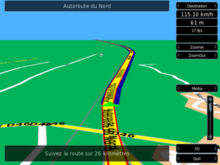
Turn-by-turn navigation is a feature of some satellite navigation devices where directions for a selected route are continually presented to the user in the form of spoken or visual instructions. The system keeps the user up-to-date about the best route to the destination, and is often updated according to changing factors such as traffic and road conditions. Turn-by-turn systems typically use an electronic voice to inform the user whether to turn left or right, the street name, and the distance to the next turn.
Here WeGo is a web mapping and satellite navigation software, operated by HERE Technologies and available on the Web and mobile platforms. It is based on HERE's location data platform, providing its in-house data, which includes satellite views, traffic data, and other location services. Maps are updated every two or three months.
