

Trent Park Cemetery is a cemetery run by the Islington and Camden Cemetery Services located in Cockfosters Road, Cockfosters, north London. [1] It is adjacent to Cockfosters tube station and Trent Park.


Trent Park Cemetery is a cemetery run by the Islington and Camden Cemetery Services located in Cockfosters Road, Cockfosters, north London. [1] It is adjacent to Cockfosters tube station and Trent Park.
The cemetery is of a lawn style with only bronze or granite memorial plaques laid flat allowed.
Trent Park Cemetery was opened in 1960. [2] It was built on land in agricultural use within Trent Park that originally formed part of Enfield Chase hunting park. [3]

The Northern line is a London Underground line that runs from North London to South London. It is printed in black on the Tube map. The Northern line is unique on the Underground network in having two different routes through central London, two southern branches and two northern branches. Despite its name, it does not serve the northernmost stations on the Underground, though it does serve the southernmost station at Morden, the terminus of one of the two southern branches.

The Piccadilly line is a deep-level London Underground line running from the north to the west of London. It has two branches, which split at Acton Town, and serves 53 stations. The line serves Heathrow Airport, and some of its stations are near tourist attractions such as Piccadilly Circus and Buckingham Palace. The District and Metropolitan lines share some sections of track with the Piccadilly line. Printed in dark blue on the Tube map, it is the fourth busiest line on the Underground network, with over 210 million passenger journeys in 2011/12.

The London Borough of Islington is a London borough which forms part of Inner London. Islington has an estimated population of 215,667. It was formed in 1965 under the London Government Act 1963, which simultaneously abolished the metropolitan boroughs of Islington and Finsbury.

Cockfosters is a suburb of north London to the east of Chipping Barnet, lying partly in the London Borough of Enfield and partly in the London Borough of Barnet. Before 1965, it was in the counties of Middlesex and Hertfordshire.

Pentonville Road is a road in Central London that runs west to east from Kings Cross to City Road at The Angel, Islington. The road is part of the London Inner Ring Road and part of the boundary of the London congestion charge zone.

Islington was a civil parish and metropolitan borough in London, England. It was an ancient parish within the county of Middlesex, and formed part of The Metropolis from 1855. The parish was transferred to the County of London in 1889 and became a metropolitan borough in 1900. It was amalgamated with the Metropolitan Borough of Finsbury to form the London Borough of Islington in Greater London in 1965.

Central London is the innermost part of London, in England, spanning several boroughs. Over time, a number of definitions have been used to define the scope of Central London for statistics, urban planning and local government. Its characteristics are understood to include a high density built environment, high land values, an elevated daytime population and a concentration of regionally, nationally and internationally significant organisations and facilities.

London Dial-a-Ride run by Transport for London (TfL) is a door-to-door community transport service for people with a permanent or long term disability or health problem who are unable, or virtually unable to use public transport. In 2019, there were around 40,000 members of the scheme.

Islington North is a constituency in Greater London represented in the House of Commons of the UK Parliament since 1983 by Jeremy Corbyn, who was Leader of the Labour Party and Leader of the Opposition from 2015 to 2020.

Enfield Southgate is a constituency in the House of Commons of the UK Parliament. It was created in 1950 as Southgate, and has been represented since 2017 by Bambos Charalambous, a member of the Labour Party.

There have been two railway stations named Maiden Lane in the present London Borough of Camden, in north London, England. The stations, named after the nearby road, were close to each other, but on different lines.

London Buses route 29 is a Transport for London contracted bus route in London, England. Running between Wood Green and Trafalgar Square, it is operated by Arriva London.

St Pancras and Islington Cemetery is a cemetery in East Finchley, North London. Although it is situated in the London Borough of Barnet, it is run as two cemeteries, owned by two other London Boroughs, Camden and Islington. The fence along the boundary which runs west to east between the two parts of the cemetery has been removed, although the line of it is still marked.

York Way is a major road in the London Borough of Islington, running north for one mile from the junction of Pentonville Road and Euston Road, adjacent to King's Cross railway station towards Kentish Town and Holloway. At its northern end the road becomes Brecknock Road. For its entire length York Way forms the boundary between the London Boroughs of Islington and Camden.

Caledonian Road passes for about a mile and a half north–south through the London Borough of Islington. It connects North London, from Camden Road near its junction with Holloway Road, and central London's Pentonville Road in the south. It is known colloquially as the "Cally" and forms the entirety of the A5203.

The London Borough of Camden is a London borough in Inner London. Camden Town Hall, on Euston Road, lies 1.4 mi (2.3 km) north of Charing Cross. The borough was established on 1 April 1965 from the area of the former boroughs of Hampstead, Holborn, and St Pancras—which together, prior to that date, had comprised part of the historic County of London.

Ludgrove Hall is an historic manor house in the parish of Monken Hadley, formerly within the county of Middlesex. Today the property has been overtaken by the suburbs of North London, and is situated on Games Road, Cockfosters, on the edge of Monken Hadley Common. It was originally a private home but then became Ludgrove School and has now been converted to flats. Additional buildings have since been constructed in the grounds.Following compulsory purchase it was used as residential accommodation for students at Trent Park College of Education in 1960s and 70s. This was later taken over by Middlesex University.

The Burma Railway Memorial is a memorial near Mornington Crescent tube station, in Camden High Street, London, to the thousands of British civilian and military prisoners of war in the Far East who died of disease, starvation or maltreatment while building the Burma Railway during the Second World War.

The Cockfosters Water Tower is a water tower in Cockfosters Road, north London, on the edge of Trent Park, that is known for its hyperboloid structure. It is adjacent to the Cockfosters Reservoir.

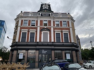
The Archway Tavern in Archway, London, is on Highgate Hill near Archway tube station.