
Williams County is located on the western border of the U.S. state of North Dakota, next to Montana. As of the 2020 census, the population was 40,950. making it the fifth most populous county in North Dakota. Its county seat is Williston.

Epping is a city in Williams County, North Dakota, United States. The population was 84 at the 2020 census.

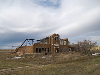
Springbrook is a city in Williams County, North Dakota, United States. The population was 37 at the 2020 census. It is also spelled Spring Brook.

Williston is a city in and the county seat of Williams County, North Dakota, United States. The 2020 census gave its population as 29,160, making Williston the sixth-most populous city in North Dakota. The city's population nearly doubled between 2010 and 2020, due largely to the North Dakota oil boom.
Wheelock is a ghost town in Wheelock Township, Williams County, in the northwestern part of the U.S. state of North Dakota. In 1938, the Federal Writers' Project found a population of 115 in Wheelock. In the 1990 census, the population was 23. All census population figures after 1990 are estimates. The town was disincorporated in 1994.
Ideal is an unincorporated community in northern Tripp County, South Dakota, United States. It lies north of the city of Winner, the county seat. Its elevation is 1,886 feet (575 m). The population of the CDP was 86 at the 2020 census.

Zahl is an unincorporated community in northwestern Williams County, North Dakota, United States. It lies along North Dakota Highway 50 north of the city of Williston, the county seat of Williams County.

McGregor is an unincorporated community and census-designated place (CDP) in northeastern Williams County, North Dakota, United States. It lies along North Dakota Highway 40, northeast of the city of Williston, the county seat of Williams County. McGregor's elevation is 2,218 feet (676 m). Although unincorporated, it has a post office, with the ZIP code of 58755. It was first listed as a CDP prior to the 2020 census.

Norwich is an unincorporated community in western McHenry County, North Dakota, United States. It lies along U.S. Route 2 southwest of the city of Towner, the county seat of McHenry County. Norwich's elevation is 1,549 feet (472 m). It is unincorporated, and had a post office with the ZIP code of 58768. Though the post office closed May 4, 1996, the ZIP code is still valid for use.

Arvilla is an unincorporated community in central Grand Forks County, North Dakota, United States. It lies along U.S. Route 2, west of the city of Grand Forks, the county seat of Grand Forks County. Its elevation is 1,004 feet (306 m). The community was first named Orange for Orange County, New York; it was renamed Arvilla for Arvilla Estella Hersey, the wife of a local farmer. Although Arvilla is unincorporated, it has a post office, with the ZIP code of 58214.
Penn is an unincorporated community in western Ramsey County, North Dakota, United States. It lies along U.S. Route 2, northwest of the city of Devils Lake, the county seat of Ramsey County. Its elevation is 1,467 feet (447 m). The community was first named Lauren for the townsite owner, Lauren, and was later renamed Penn for English stockholders. It has a post office with the ZIP code 58362.

Menoken is an unincorporated community and a census-designated place (CDP) in southwestern Burleigh County, North Dakota, United States. It was designated as part of the U.S. Census Bureau's Participant Statistical Areas Program on June 10, 2010. It was not counted separately during the 2000 Census, but was included in the 2010 Census, where a population of 70 was reported.

Newcastle is an unincorporated community and census-designated place (CDP) in southwestern Iron County, Utah, United States. It lies along State Route 56, 30 miles (48 km) west of Cedar City. Its elevation is 5,312 feet (1,619 m) above sea level. Newcastle has a post office with the ZIP code of 84756. The population was 247 at the 2010 census. Newcastle was founded in 1910 by citizens of the more isolated Pinto.
Moscow is an unincorporated community and census-designated place (CDP) in Muscatine County, Iowa, United States. As of the 2020 census, the population was 290. It has a post office, with the ZIP code of 52760, which opened on May 1, 1837. The community is part of the Muscatine Micropolitan Statistical Area.

Beulah is a census-designated place (CDP) in eastern Crook County, Wyoming, United States, along Sand Creek, a tributary of the Belle Fourche River. According to local residents, the population is 33. When the 2010 census reported the population as 73, the highway sign at the town entrance was changed. In 2012, Beulah residents succeeded in appealing to the Wyoming Governor to remove the new sign and replace it with one that proclaimed the population to be 33.

Boys Ranch is a census-designated place and unincorporated community in northeastern Oldham County, Texas, United States, on the site of the original county seat, Tascosa. It lies along U.S. Route 385, northeast of the city of Vega, the county seat of Oldham County. Although Boys Ranch is unincorporated, it has a post office, with the ZIP Code of 79010. Boys Ranch is a residential community serving boys and girls ages 5 to 18. It was founded in 1939 by Cal Farley for troubled youth and is now a census-designated place. This was a new CDP for the 2010 census with a population of 282.
Green Mountain is a rural unincorporated community and census-designated place (CDP) in Marshall County, Iowa, United States. It is located in Marion Township. As of the 2020 census the population of Green Mountain was 113.
Trenton is an unincorporated community and census-designated place (CDP) in Henry County, Iowa, United States. It is in the northwest part of the county, 10 miles (16 km) northwest of Mount Pleasant, the county seat.
Blacktail is an unincorporated community and census-designated place (CDP) built around Blacktail Lake in Williams County, North Dakota, United States. It was first listed as a CDP prior to the 2020 census.
Long Creek is an unincorporated community and census-designated place (CDP) in Williams County, North Dakota, United States. It was first listed as a CDP prior to the 2020 census.


