
The 2012 Pacific typhoon season was a slightly above average season that produced 25 named storms, fourteen typhoons, and four intense typhoons. It was a destructive and the second consecutive year to be the deadliest season, primarily due to Typhoon Bopha which killed 1,901 people in the Philippines. It was an event in the annual cycle of tropical cyclone formation, in which tropical cyclones form in the western Pacific Ocean. The season ran throughout 2012, though most tropical cyclones typically develop between May and October. The season's first named storm, Pakhar, developed on March 28, while the season's last named storm, Wukong, dissipated on December 29. The season's first typhoon, Guchol, reached typhoon status on June 15, and became the first super typhoon of the year on June 17.

The 2013 Pacific typhoon season was the most active Pacific typhoon season since 2004, and the deadliest since 1975. It featured Typhoon Haiyan, one of the most powerful storms and one of the strongest landfalling tropical cyclones in history. It was an above-average season with 31 named storms, 13 typhoons, and five super typhoons. The season's first named storm, Sonamu, developed on January 4 while the season's last named storm, Podul, dissipated on November 15. Despite the activity, most of the first seventeen named storms before mid-September were relatively weak, as only two of them reached typhoon intensity. Total damage amounted to at least $26.41 billion (USD), making it at the time the costliest Pacific typhoon season on record; it is currently the fourth costliest, behind the 2018, 2019 and 2023 seasons.

The 2015 Pacific typhoon season was a slightly above average season that produced twenty-seven tropical storms, eighteen typhoons, and nine super typhoons. The season ran throughout 2015, though most tropical cyclones typically develop between May and November. The season's first named storm, Mekkhala, developed on January 15, while the season's last named storm, Melor, dissipated on December 17. The season saw at least one named tropical system forming in each of every month, the first time since 1965. Similar to the previous season, this season saw a high number of super typhoons. Accumulated cyclone energy (ACE) during 2015 was extremely high, the third highest since 1970, and the 2015 ACE has been attributed in part to anthropogenic warming, and also the 2014-16 El Niño event, that led to similarly high ACE values in the East Pacific.

The 2016 Pacific typhoon season is considered to have been the fourth-latest start for a Pacific typhoon season since reliable records began. It was an average season, with a total of 26 named storms, 13 typhoons, and six super typhoons. The season ran throughout 2016, though typically most tropical cyclones develop between May and October. The season's first named storm, Nepartak, developed on July 3, while the season's last named storm, Nock-ten, dissipated on December 28.

The 2017 Pacific typhoon season was a below-average season in terms of accumulated cyclone energy and the number of typhoons and super typhoons, and the first since the 1977 season to not produce a Category 5-equivalent typhoon on the Saffir–Simpson scale. The season produced a total of 27 named storms, 11 typhoons, and only two super typhoons, making it an average season in terms of storm numbers. It was an event in the annual cycle of tropical cyclone formation, in which tropical cyclones form in the western Pacific Ocean. The season runs throughout 2017, though most tropical cyclones typically develop between May and October. The season's first named storm, Muifa, developed on April 25, while the season's last named storm, Tembin, dissipated on December 26. This season also featured the latest occurrence of the first typhoon of the year since 1998, with Noru reaching this intensity on July 23.

The 2018 Pacific typhoon season was at the time, the costliest Pacific typhoon season on record, until the record was beaten by the following year. The season was well above-average, producing twenty-nine storms, thirteen typhoons, seven super typhoons and six Category 5 tropical cyclones. The season ran throughout 2018, though most tropical cyclones typically develop between May and October. The season's first named storm, Bolaven, developed on January 3, while the season's last named storm, Man-yi, dissipated on November 28. The season's first typhoon, Jelawat, reached typhoon status on March 29, and became the first super typhoon of the year on the next day.

Typhoon Kai-tak, known in the Philippines as Severe Tropical Storm Helen, was a mild tropical cyclone that affected China, Vietnam and Laos. It was the seventh typhoon and the thirteenth named storm of the 2012 Pacific typhoon season. The storm killed 41 people and caused a sum of US$765 million in losses. Kai-tak can be tracked back to the broad area of disturbance embedded in a monsoonal trough that was first spotted, early on August 10. It was only at midnight, on August 16, when the JMA officially declared Kai-tak a typhoon. On the morning of August 17, the windspeed dropped to 60 knots and was no longer a typhoon. The typhoon caused heavy damage in China's two provinces killing four people and causing huge economic loss. Kai-Tak slammed the northern Philippines triggering flash floods and landslides and killing at least ten people, one week after deadly monsoon rains battered the country. In Vietnam, Kai-Tak has stormed across the country's north bringing high winds and floods to several areas including the capital Hanoi.

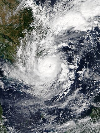
Typhoon Lekima was the second most intense tropical cyclone worldwide in 2013, as well as the twenty-ninth named storm and the eleventh typhoon of the annual typhoon season. It developed into a tropical storm late on October 20. After Lekima intensified into a typhoon and underwent rapid deepening in a very favorable environment on October 22, the system reached peak intensity on the following day. Maintaining its strength for over one day, Lekima began to weaken on October 24, as stronger vertical wind shear and mid-latitude westerlies began to make the typhoon significantly decay. On October 26, Lekima transitioned into an extratropical cyclone east of Japan.
Tropical Storm Podul, known in the Philippines as Tropical Depression Zoraida, was a weak but destructive tropical cyclone that affected the Philippines shortly after the devastating Typhoon Haiyan. The 31st named storm of the 2013 Pacific typhoon season, Podul developed as a tropical depression on November 11 between Palau and the Philippine island of Mindanao. The system moved west-northwestward and struck Davao Oriental in Mindanao on November 12, bringing heavy rainfall that killed two people and disrupted relief efforts following Haiyan. After crossing the Philippines, the depression intensified into Tropical Storm Podul on November 14. Shortly thereafter, the storm struck southeastern Vietnam, and its circulation dissipated on November 15. In Vietnam, Podul produced heavy rainfall that resulted in severe flooding. The storm damaged or destroyed 427,258 houses, and overall damage was estimated at 4.1 trillion₫. Podul killed 44 people in the country and caused 66 injuries.

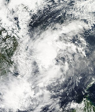
Tropical Storm Lingling, known in the Philippines as Tropical Depression Agaton, was a weak but deadly tropical cyclone that affected the Philippines in January 2014. The first named storm of the annual typhoon season, this early-season cyclone remained very disorganized throughout its lifespan. Lingling was the first major natural disaster in the Philippines after Typhoon Haiyan just two months earlier, as it caused widespread landslide incidents and floods in Mindanao, resulting in 70 deaths and damage amounting to over 566 million pesos on the island.

Tropical Storm Rai was a weak and short-lived tropical cyclone which affected Indochina in September 2016. Formed from a tropical disturbance on September 11, the system developed into a tropical storm and reached its peak intensity on September 12, before making landfall in Vietnam and affecting Laos, Thailand and Cambodia. In Vietnam total damage reached US$73.96 million.

Severe Tropical Storm Talas was a tropical cyclone that impacted Vietnam during mid July 2017. Talas was first tracked as a tropical disturbance over in the South China Sea on July 13, and was upgraded to a tropical depression during the next day. The depression intensified into the fourth named storm of the 2017 Pacific typhoon season during July 15. Before making landfall in Vietnam, Talas reached its peak intensity as a severe tropical storm during July 16. Talas weakened to an area of low pressure on July 17 inland.

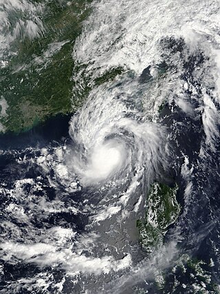
Typhoon Damrey, known in the Philippines as Severe Tropical Storm Ramil, was a strong tropical cyclone that affected the Philippines and Vietnam during early November 2017. Damrey first originated as a tropical depression over the Philippine archipelago of Visayas on October 31. Emerging into the South China Sea a few days later, the system strengthened into the second deadliest and twenty-third named storm of the 2017 Pacific typhoon season. Rapidly intensifying, Damrey became the season's tenth typhoon on November 3, reaching its peak intensity as a Category 2 on the same day. Damrey made landfall over Khánh Hoà, Vietnam on November 4 and began to rapidly weaken, fully dissipating on November 5.

The 2021 Pacific typhoon season was the second consecutive to have below average tropical cyclone activity, with twenty-two named storms, and was the least active since 2011. Nine became typhoons, and five of those intensified into super typhoons. This low activity was caused by a strong La Niña that had persisted from the previous year. The season's first named storm, Dujuan, developed on February 16, while the last named storm, Rai, dissipated on December 21. The season's first typhoon, Surigae, reached typhoon status on April 16. It became the first super typhoon of the year on the next day, also becoming the strongest tropical cyclone in 2021. Surigae was also the most powerful tropical cyclone on record in the Northern Hemisphere for the month of April. Typhoons In-fa and Rai are responsible for more than half of the total damage this season, adding up to a combined total of $2.02 billion.

Tropical Storm Son-Tinh, known in the Philippines as Tropical Storm Henry, was a weak but very deadly tropical cyclone that devastated Vietnam and Laos in July 2018. Son-Tinh originated from an area of low pressure over the Philippine Sea on July 15, 2018. Moving quickly westwards, Son-Tinh strengthened to the ninth tropical storm of the annual typhoon season on July 17. Intensifying only slightly while crossing the South China Sea, Son-Tinh made its first landfall over Hainan Island on July 18. After emerging into the Gulf of Tonkin, Son-Tinh restrengthened before making its second landfall as a tropical storm in Northern Vietnam on July 19. Once inland, Son-Tinh weakened into a low pressure area as it slowed and made a clockwise loop. The remnants of Son-Tinh then emerged back over water and regenerated into a tropical depression late on July 21.

Tropical Storm Sanba, known in the Philippines as Tropical Storm Basyang, was a weak tropical cyclone that affected southern and central parts of the Philippines in mid-February 2018. Sanba developed as a tropical depression in the open Pacific Ocean on February 8. The system moved generally westward while slowly developing, finally attaining tropical storm status on February 11. Soon after, wind shear caused the system to lose organization and remain as a minimal tropical storm through February 11 and 12. During this time, Sanba moved westwards then west-northwestwards, making landfall over northeastern Mindanao on February 13. The system weakened into a tropical depression before making another landfall in southeastern Negros later that day. After traversing the Philippine Islands, Sanba failed to reorganize significantly in the Sulu Sea and dissipated two days later west of Palawan.

Tropical Depression Josie was a weak tropical system that impacted the Philippine archipelago of Luzon in July 2018, bringing widespread flooding. The tropical depression was classified in the South China Sea on July 20, and steadily moved eastward while gradually intensifying. The storm reached its peak intensity of 1-minute sustained winds of 65 km/h while nearing the northern tip of the Ilocos Region. By July 22, the system moved northward and rapidly weakened. The system was last noted on July 23 to the northeast of Taiwan.

Typhoon Soulik was an unusually large, and the deadliest typhoon to strike the Korean Peninsula since Khanun in 2012. Soulik formed from an area of low pressure on August 15, and was the twenty-ninth tropical depression, twentieth tropical storm, tenth severe tropical storm, and sixth typhoon of the 2018 Pacific typhoon season.
Severe Tropical Storm Usagi, known in the Philippines as Tropical Storm Samuel, was a tropical cyclone that affected the Philippines and Southern Vietnam in late November 2018, causing severe damage around the Visayas region and Ho Chi Minh City. The storm formed from a disturbance in the Central Pacific basin on November 3, but did not develop into a tropical storm until almost three weeks later, on November 13. Usagi underwent rapid intensification and peaked in intensity before making its final landfall on Vũng Tàu, Bà Rịa–Vũng Tàu province as a weakening tropical storm on November 25. While never considered as a typhoon by the Japan Meteorological Agency (JMA), the Joint Typhoon Warning Center (JTWC) assessed its intensity to be equivalent to Category 2 status on the Saffir–Simpson scale. Usagi caused one death and ₱52.2 million (US$992,000) in damages in the Philippines, most of which came from agriculture. Usagi caused 3 deaths and ₫925 billion in damages in Vietnam.
Tropical Storm Barijat, known in the Philippines as Tropical Storm Neneng, was a weak tropical storm that caused flooding in the far northern regions of the Philippines and Southern China. Barijat, a replacement name for Utor which is a Marshallese word for coastal areas impacted by waves or winds, the thirty-third tropical depression and twenty-third tropical storm of the 2018 Pacific typhoon season, it was first noted as an area of convection in the South China Sea on September 6. On September 8, it was upgraded to a tropical depression, and by September 11, it intensified into a tropical storm, with the Japan Meteorological Agency (JMA) giving it the name Barijat. Barijat peaked in intensity 6 hours later, with 10-min winds of 40 knots and 1-min winds of 45 knots. Barijat continued westward, and on November 12 at 00:30 UTC, it made landfall over Zhanjiang, quickly dissipating afterwards.


