Related Research Articles

Pottawatomie County is a county located in the U.S. state of Oklahoma. As of the 2010 census, the population was 69,442. Its county seat is Shawnee.

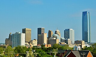
Oklahoma County is located in the central part of the U.S. state of Oklahoma. As of the 2010 census, the population was 718,633, making it the most populous county in Oklahoma. The county seat is Oklahoma City, the state capital and largest city.

McClain County is a county located in south central Oklahoma. As of the 2010 census, the population was 34,506. Its county seat is Purcell. The county was named for Charles M. McClain, an Oklahoma constitutional convention attendee.

Lincoln County is a county in eastern Central Oklahoma. As of the 2010 census, the population was 34,273. Its county seat is Chandler.

Cleveland County is a county in the central part of the U.S. state of Oklahoma. The population was 255,755 at the 2010 census, making it the third-most populous county in Oklahoma. Its county seat is Norman. The county was named after U.S. President Grover Cleveland.

Bethel Acres is a town in Pottawatomie County, Oklahoma, United States. The population was 2,895 at the 2010 census, an increase of 5.9 percent from the figure of 2,735 in 2000. It is primarily a bedroom community for people who work in the three nearby larger cities of Shawnee, Tecumseh and Oklahoma City.

Brooksville is a town in Pottawatomie County, Oklahoma, United States. It is one of the thirteen existing all-black towns in Oklahoma. The population was 63 at the 2010 census, a 30 percent decline from the figure of 90 in 2000.
Johnson is a town in north-central Pottawatomie County, Oklahoma, United States. The population was 247 at the 2010 census, a 10.8 percent increase from the figure of 223 in 2000.

Macomb is a town in Pottawatomie County, Oklahoma, United States. The population was 32 at the 2010 census, which represented a decline of 47.5 percent from the figure of 61 in 2000.
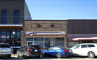
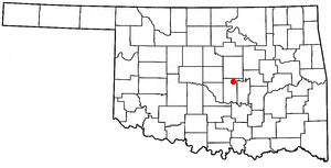
McLoud is a town in northwestern Pottawatomie County, Oklahoma, United States, and is part of the Oklahoma City Consolidated Metropolitan Area. The population was 4,044 at the 2010 census, a 14.0 percent increase from the figure of 3,548 in 2000. The town was founded in 1895 and named for John W. McLoud, attorney for the Choctaw, Oklahoma and Gulf Railroad.

Pink is a town in Pottawatomie County, Oklahoma, United States, and is part of the Oklahoma City Metropolitan Area. The only town in the United States bearing this name, Pink lies within the boundaries of the Citizen Potawatomi Nation. The 2010 census population was 2,058, a 76.7 percent increase from the figure of 1,165 in 2000.
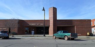
Tecumseh is a city in Pottawatomie County, Oklahoma, United States. The population was 6,457 at the 2010 census, a 5.9 percent increase from the figure of 6,098 in 2000. It was named for the noted Shawnee chief, Tecumseh, and was designated as the county seat at Oklahoma's statehood. A county-wide election moved the seat to Shawnee in 1930.

Tribbey is a town in Pottawatomie County, Oklahoma, United States.The community was named for Alpheus M. Tribbey, landowner. The population was 391 at the 2010 census, a 43.2 percent gain from the figure of 273 in 2000.
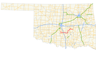
State Highway 59, abbreviated SH-59, is a 93-mile (150 km) state highway in central Oklahoma. It runs from Criner, Oklahoma in McClain Co. to Wewoka.
Central Oklahoma is the geographical name for the central region of the U.S. state of Oklahoma. It is also known by the Oklahoma Department of Tourism designation, Frontier Country, defined as the twelve-county region including Canadian, Grady, Logan, Oklahoma, Cleveland, McClain, Payne, Lincoln, Pottawatomie, Seminole, Okfuskee, and Hughes counties.

Oklahoma's 5th congressional district is a congressional district in the U.S. state of Oklahoma. It borders all of the other congressional districts in the state except the 1st district. It is densely populated and covers almost all of Oklahoma County and all of Pottawatomie and Seminole counties. Although it leans Republican, with a Cook PVI rating of R+7, it is still considered the least Republican district in the state.

Bethel High School is a high school located in Bethel Acres, in Pottawatomie County, Oklahoma. It serves approximately 400 students and is part of the Bethel School District.
Bellemont is a populated place in Pottawatomie County, Oklahoma at an elevation of 1,047 feet. It is located less than 7 miles west-southwest of Prague, Oklahoma.
Garden Grove is a populated place in Pottawatomie County, Oklahoma, at an elevation of 958 feet. It is located southwest of Prague, Oklahoma.
References
- ↑ "Trousdale". Geographic Names Information System . United States Geological Survey . Retrieved July 10, 2021.
- ↑ "Trousdale, Oklahoma". RoadsideThoughts. Retrieved June 30, 2021.
- ↑ "Tribbey, Oklahoma to Trousdale, Oklahoma". Google Maps. Retrieved June 30, 2021.
- 1 2 3 4 "Trousdale". Rootsweb.com. Retrieved June 30, 2021.
Municipalities and communities of Pottawatomie County, Oklahoma, United States | ||
|---|---|---|
| Cities | 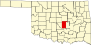 | |
| Towns | ||
| CDP | ||
| Other unincorporated communities | ||
| Ghost towns | ||
| Footnotes | ‡This populated place also has portions in an adjacent county or counties | |
Coordinates: 35°02′28″N97°02′34″W / 35.04111°N 97.04278°W
| | This Oklahoma state location article is a stub. You can help Wikipedia by expanding it. |