
The economy of Madagascar is a market economy and is supported by Madagascar's well-established agricultural industry and emerging tourism, textile and mining industries. Malagasy agriculture produces tropical staple crops such as rice and cassava, as well as cash crops such as vanilla and coffee. Madagascar's wealth of natural resources supports its sizable mining industry. Additionally, Madagascar's status as a developing nation exempts Malagasy exports from customs protocol in some areas, notably the United States and European Union. These exemptions have supported the growth of the Malagasy textile industry. Despite Madagascar's natural resources and developing industries, the 2009 Malagasy political crisis—considered by the international community to be an illegal coup—deterred foreign investments in Madagascar and caused the Malagasy economy to decline. Foreign investments have resumed following the resumption of elections in early 2014. At 2018, Madagascar is one of the world's fastest-growing economies.

Tôlanaro, Tolagnaro or Taolagnaro is a city on the southeast coast of Madagascar. It is the capital of the Anosy Region and of the Tôlanaro District. It has been a port of local importance since the early 1500s, and a new port, the Ehoala Port, has been built by QMM and the World Bank. Formerly Fort-Dauphin, it was the first French settlement in Madagascar.

Sare is a village in the traditional Basque province of Labourd, now a commune in the Pyrénées-Atlantiques department in south-western France on the border with Spain.

Niono is a town and commune located in the Ségou Region of Mali. The commune has an area of approximately 491 square kilometers and includes the town and 20 of the surrounding villages. In the 2009 census it had a population of 91,554. The town is the capital of the Niono Cercle, one of seven subdivisions (cercles) of the Ségou Region. It lies on the northwest edge of the Inner Niger Delta, near the main channel of the Niger River.
Vohimarina is a village and commune in Madagascar. It belongs to the district of Vohibato District, which is a part of Haute Matsiatra Region. The population of the commune was estimated 12559 in 2018.
Androy is the most southerly region of Madagascar. It covers an area of 19,540 km2, and had a population of 903,376 inhabitants in 2018. The administrative capital is Ambovombe-Androy, and the chief administrator is Michael Andrianirina.

Araporã is a Brazilian municipality located in the west of the state of Minas Gerais. Its population as of 2020 was 6,931 people living in a total area of 298 square kilometres (115 sq mi). The city belongs to the statistical mesoregion of Triângulo Mineiro and Alto Paranaíba and to the microregion of Uberlândia. It became a municipality in 1992.

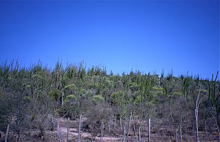
Anosy is one of the 22 regions of Madagascar. It is located in the southeast of the country, on the eastern side of what was once the Toliara Province. The name Anosy means "island(s)" in Malagasy.

Agriculture employs the majority of Madagascar's population. Mainly involving smallholders, agriculture has seen different levels of state organisation, shifting from state control to a liberalized sector.

Alakamisy Anativato is a town and commune in Madagascar. It belongs to the district of Betafo, which is a part of Vakinankaratra region. It is situated in a distance of 127 km South-West of Antananarivo and 21 km West of Antsirabe. The population of the commune was estimated 9,407 in 2018.
Mahaiza is a town and commune in Madagascar. It belongs to the district of Betafo, which is a part of Vakinankaratra Region. The population of the commune was estimated to be approximately 24,244 in 2018 and is situated at 8.3 km south west from Betafo.
Vohimarina is a village and commune in Madagascar. It belongs to the district of Vohibato District, which is a part of Haute Matsiatra Region. The population of the commune was estimated 12559 in 2018.
Ivato is a town and commune in Madagascar. It belongs to the district of Vohipeno, which is a part of the region of Fitovinany. The population of the commune was 2,698 in 2018.
Mahaly is a rural commune in Madagascar. It belongs to the district of Amboasary Sud, which is a part of Anosy Region. The population of the commune was estimated 15197 in 2018. It is situated at 45 km from Tsivory.

Wateni is a rural commune in the Cercle of Sikasso in the Sikasso Region of southern Mali. The commune covers an area of 211 square kilometers and includes ten villages. In the 2009 census it had a population of 6,701. The village of N'Tjila, the administrative center (chef-lieu) of the commune, is 94 km west-northwest of Sikasso.
Ambatomanoina is a rural commune in Analamanga Region, in the Central Highlands of Madagascar. It belongs to the district of Anjozorobe and its populations numbers to 21,779 in 2018.
Talata Volonondry is a rural commune in Analamanga Region, in the Central Highlands of Madagascar. It belongs to the district of Antananarivo Avaradrano and its populations numbers to 18,314 in 2018.

Ambohimanga Rova is a rural commune in Analamanga Region, in the Central Highlands of Madagascar. It belongs to the district of Antananarivo Avaradrano and its populations numbers to 20,872 in 2018.
Ambongamarina is a rural commune in the Analamanga Region, Madagascar, 110 km north-east of the capital Antananarivo, in the district of Anjozorobe. It has a population of 15,382 inhabitants in 2018. It's principally inhabitat by Merina and Sihanaka people.
Lamosina is a village and commune in Madagascar. It belongs to the district of Vohibato, which is a part of Haute Matsiatra Region. The population of the commune was estimated to be 11534 in 2018.

