
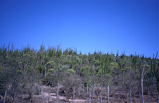
The Toliara Province is a former province of Madagascar with an area of 161,405 square kilometres (62,319 sq mi). It had a population of 2,229,550. Its capital was Toliara. Near Toliara was the "spiny forest".
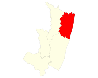
Sava is a region in northern Madagascar. Its capital is Sambava. Until 2009 Sava belonged to Antsiranana Province. The region is situated at the northern part of the east coast of Madagascar. It is bordered by the region Diana to the north, Sofia to the west, and Analanjirofo to the south. As of 2018, its population was 1,123,013 and the total area is 25,518 km2 (9,853 sq mi). The region contains wild areas such as Marojejy National Park.

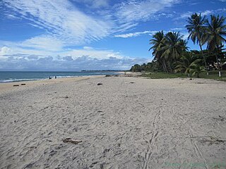
Berenty Reserve is a small private reserve, near Amboasary Sud, Anosy. It is situated along the Mandrare River, set in the semi-arid spiny forest ecoregion of the far south of Madagascar. For more than three decades the late primatologist Alison Jolly, other researchers and students have visited Berenty to conduct fieldwork on lemurs. The reserve is also a favourite for visitors who want to see some of Madagascar's endemic bird species, which include owls and couas.
Androy is the most southerly region of Madagascar. It covers an area of 19,540 km2, and had a population of 903,376 inhabitants in 2018. The administrative capital is Ambovombe-Androy.

Atsimo-Atsinanana is a region in Madagascar. Its capital is Farafangana. The region used to be part of the Fianarantsoa Province.

Fitovinany is a region located in southeast Madagascar. Its capital is Manakara. It is inhabited by the Antemoro people.
Betioky is a town in Atsimo-Andrefana Region, Madagascar and is crossed by the Route nationale 10. The population is 25,612 inhabitants in 2018.
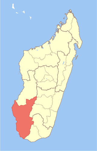
Atsimo-Andrefana is a region of Madagascar. It borders Menabe in north, Amoron'i Mania and Haute Matsiatra in northeast, Ihorombe and Anosy in east and Androy in southeast. The capital is Toliara and the population was 1,799,088 in 2018. Atsimo Andrefana is geographically the largest of all Malagasy regions with an area of 66,236 km2 (25,574 sq mi).

Anosy is one of the 22 regions of Madagascar. It is located in the southeast of the country, on the eastern side of what was once the Toliara Province. The name Anosy means "island(s)" in Malagasy.
Berenty is a town and commune in Madagascar. It belongs to the district of Ankazoabo, which is a part of Atsimo-Andrefana Region. The population of the commune was estimated to be approximately 1,000 in 2001 commune census.
Ifotaka is a town and commune in Madagascar. It belongs to the district of Amboasary Sud, which is part of Anosy Region. The population of the commune was estimated to be approximately 21.750 in 2018.
Tanandava Sud is a town and commune in Madagascar. It belongs to the district of Amboasary Sud, which is a part of Anosy Region. It has a population of 9586 inhabitants in 2018.
Tanandava may refer to one of the following locations in Madagascar:

Amboasary Sud is a town in Anosy, Madagascar. It is the main town of Amboasary Sud District. It has a population of 45,989 in 2018.
Befokata Sud is a district in the region of Atsimo-Atsinanana in Madagascar. The district has an estimated population in 2020 was 57,750.
Route nationale 13 is a primary highway in Madagascar of 493 km, running from Ihosy to Tolagnaro (Fort-Dauphin). It crosses the regions of Ihorombe, Androy and Anosy.
Farafangana is a district of Atsimo-Atsinanana in Madagascar. The district has an area of 2,824 km2 (1,090 sq mi), and the estimated population in 2020 was 436,226.

Morombe is a district of Atsimo-Andrefana in Madagascar. It can be reached by the National road 55 or pirogue from Morondava. It is situated at 283 km from Tulear. The district has an area of 7,784 km2 (3,005 sq mi), and the estimated population in 2020 was 231,431.
Vangaindrano is a district of Atsimo-Atsinanana in Madagascar. The area is 4,817 km2 (1,860 sq mi) and the population was estimated to be 376,110 in 2020.
Ankazoabo is a district in Atsimo-Andrefana Region, Madagascar. 10700 ha of the district are cultivated. An airport serves within the district.

