Tsnungwe

Last updated

Tsnungwe
tse:ning-xwe
Le-lding xontah.jpg
łe:lding xontah - mouth of the South Fork of the Trinity River, principal Tsnungwe village
Total population
150-200
Regions with significant populations
California (Salyer )
Languages
Hupa, Chimariko

The Tsnungwe (current Hupa-language orthography, own name: Tse:ningxwe - "Tse:ning-din (Ironside Mountain) People") or Tsanunghwa are a Native American people indigenous to the modern areas of the lower South Fork Trinity River (yisinch'ing-qeh), Willow Creek (xoxol-ding), Salyer (miy-me'), Burnt Ranch (tse:n-ding/tse:ning-ding) and New River (Yiduq-nilin) along the Trinity River (hun' 'river') in Trinity and Humboldt County in California. [1] The Tsnungwe were a bilingual Hupa-Chimariko-speaking people and are known by the Hupa-speaking peoples as tse:ning-xwe. [2] The primary language was the Tsnungwe dialect of Hupa, and the secondary language was Chimariko, although spoken with a Hupa accent. [3]

Contents

The Tsnungwe include two sub-groups called łe:lxwe ('People of łe:l-ding') after their most important settlement and religious center, and the Chima:lxwe'/Chimalakwe/Tł'oh-mitah-xwe ('grass, prairies-amongst-people') along New River. The Karuk living north of the Salmon River Divide called the Chima:lxwe'/Chimalakwe/Tł'oh-mitah-xwe Akráak va'ára ('New River People'). [4] The Norelmuk Wintu from Hayfork called the Tsnungwe Num-nor-muk. [5]

Because their language is a dialect of the Hupa language, they are also called South Fork Hupa. Other tribal names refer to their territories occupied: South Fork Indians, Burnt Ranch, South Fork Trinity Tribe, and Kelta/Tlelwe/Hlelwe/Tlelding/Leldin Tribe or Tlohomtahhoi, Chaltasom. [6]

Neighboring tribes to the Tsnungwe include the Yurok, Redwood Creek Hupa, Hoopa Valley Hupa, Wiyot, Chimariko, Shasta, Karuk, and Wintu. Often times, Tsnungwe spoke many Native languages. [7] C. Hart Merriam referred to Tsnungwe leader Saxey Kidd as "a well-known polyglot," speaker of many languages.

Federal recognition

The Tsnungwe descendants are members of the Tsnungwe Council : recognized by both Humboldt and Trinity counties, previously recognized by the United States of America, and working to have that federally-recognized status restored. [8] [9]

Culture

The traditional Tsnungwe diet included salmon, steelhead, Pacific lamprey "eels," black tail deer, and other local animals and plants. [10] [11]

Language

The language of the Tsnungwe is considered a dialect of the Hupa language of the Pacific Coast Athabaskan language group of North American native languages. This language (Dining'xine:wh 'Hupa-speaking people', 'Hupa Indians') with various dialects is spoken (Tse:ning-xwe, dialect of South Fork and New River areas); (na:tinixwe 'Hoopa Valley Hupa'); (Chilula/Whilkut/Me:w-yinaq/Whiyłqit 'Redwood Creek Hupa'). [12] [13]

Villages

Willow Creek area villages

misqine:q'it/nisking-q'it, nants'ing-tah (Clover Flat), niskin-ji-ding/niskinje:ndihding (upriver from Willow Creek), da:chwan'-ding (opposite niskin-ji-ding), da:chwan'-ding mima:n-ch'ing (opposite of da:chwun'-ding, Camp Kimtu), saqe:q'it (alternative: so-ke'a-keit, sock-kail-kit), saqe:q'it mima:n-ch'ing (opposite of saqe:q'it), yinaq-xa:-ding/yinuq xa:-ti-nit (all three at Willow Creek), tł'ohday-kyoh-q'it, xowiyk'iłxowh-ding (formerly: k'iqin-sa'an-ding, Knight's Trailer Park), tse:-ding (opposite xowiyk'iłxowh-ding/Knight's Trailer Park), xoxo:ch'e:lding (at the mouth of Willow Creek), minq'it-ch-ding (Enchanted Springs), q'aykist ch'e:xahsding (Gambi's, formerly: China Flat), t'unchwing-tah (alternative: tash-huan-tat, tash-wan-ta), d'ahilding (alternative: a-hel-tah, ta-hail-ta, Whitson's), yinaq-xa:-ding (just above the mouth of Willow Creek). [14] [15]

South Fork Trinity area (yisinch'ing-qeh) villages

łe:l-ding (also: Tlelding 'place where the rivers (South Fork and Trinity) meet', about one mile downriver from today's Salyer, largest and leading Tsnungwe settlement; ancient times: a k'ixinay village), including the three sub-villages me:łchwin-q'it, ta:k'iwe:ltsil-q'it (on the other side of the mouth of the South Fork), ta:ng'ay-q'it (old name was mituq'-q'it-ding); ch'iłte:l-ding, chway-me' (Sandy Bar), dahchiwh-ding (about 12 miles above the mouth of the river), dilchwehch-ding (also: hay nahdiyaw tehłchwin-ding 'place where the money grows', once an important rich settlement at the mouth of Campbell Creek),łichiwh-ding, tł'oh-wa:ne/xołtsowch-ding (Saxey Ranch), niłtuq-tah-ding (mouth of Mosquito Creek into Grouse Creek), qosta:n-ding, yahts'ame', yidahtich'inahding (Ammon Ranch), yunihting (Todd Ranch).

Trinity River (South Fork – Cedar Flat area) villages

hun'-kya:w-qeh (at Trinity River), ti-dił -ding (downstream from Salyer), xoling-kyoh-miye, miy-me' (alternative: me'-yemma, me-em-ma, Old Campbell Ranch/Fountain Ranch), k'inunq'-ding, tse:-q'it (Swanson's), no:k'iwowh-ding (downstream from tse:-q'it/Swanson's), kin-sa'an-ting (Irvings, Hawkins Bar), tse:łe:nga:ding (downstream from kin-sa'an-ting/Irvings), ta:wha: wh-ding (Gray's Flat), xowung-q'it (at a lake, near xweda'ay-sa'an-me'/Chesbro's), xweda'ay-sa'an-me' (Wells, Chesbro's).

Burnt Ranch and New River area villages

tse:n-ding/tse:-nung-din (Burnt Ranch, large settlement), tse:nung-axis-ding (near China Slide, upstream from yinuq-dinung-ting/McDonald's at Burnt Ranch), yinuq-dinung-ting (McDonald Ranch, Burnt Ranch), ch'e:nantiłting (at the mouth of the New River), ch'e:na:dawhding (Dyer's, Bell's Flat), ch'ixe:ne:wh-din (also: 'xolish na:xoxuynta' – Martha Dyer Ziegler's, upstream from qowh-ding), k'iłna:dil mito' (Hoboken), k'iyawh-michwan (at China Creek, also: xolish ch'ena:xolxolding – China Creek), łige:y de:-dilła:t-ding (upstream from tł'ohne:s-ding/Quimby), tł'ohne:s-ding (at the mouth of Quinby Creek, Ladd's, Thomas', Quimby), qowh-ding (south of Panther Creek), tł'ohsch'il'e:n-ding (Daily's, before: Moses Patterson), tse:na:ning'a:ding (at the confluence of East Fork and New River), yiduq-nilin (New River), yiduq-łe:na:lding (at the forks of the New River upstream from Denny), tł'oh-mitah-xwe (Hupa speakers in New River villages).

Related Research Articles

<span class="mw-page-title-main">Trinity County, California</span> County in California, United States

Trinity County is a county located in the northwestern portion of the U.S. state of California. Trinity County is rugged, mountainous, heavily forested, and lies along the Trinity River within the Salmon and Klamath Mountains. It is also one of three counties in California with no incorporated cities.

<span class="mw-page-title-main">Willow Creek, California</span> Census-designated place in California, United States

Willow Creek is a census-designated place (CDP) in Humboldt County, California, United States. The population was 1,710 at the 2010 census, down from 1,743 at the 2000 census. Residents of this small mountain town are commonly referred to as "Willow Creekers." The town is located around 30 miles (48 km) from county seat and harbor city Eureka, with the two places vastly differing in climate.

<span class="mw-page-title-main">Klamath River</span> River in Oregon and California, United States

The Klamath River flows 257 miles (414 km) through Oregon and northern California in the United States, emptying into the Pacific Ocean. By average discharge, the Klamath is the second largest river in California after the Sacramento River. It drains an extensive watershed of almost 16,000 square miles (41,000 km2) that stretches from the arid country of south-central Oregon to the temperate rainforest of the Pacific coast. Unlike most rivers, the Klamath begins in the high desert and flows toward the mountains – carving its way through the rugged Cascade Range and Klamath Mountains before reaching the sea. The upper basin, today used for farming and ranching, once contained vast freshwater marshes that provided habitat for abundant wildlife, including millions of migratory birds. Most of the lower basin remains wild, with much of it designated wilderness. The watershed is known for this peculiar geography, and the Klamath has been called "a river upside down" by National Geographic magazine.

<span class="mw-page-title-main">Trinity River (California)</span> River in northern California

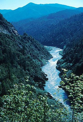
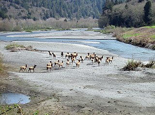
The Trinity River is a major river in northwestern California in the United States and is the principal tributary of the Klamath River. The Trinity flows for 165 miles (266 km) through the Klamath Mountains and Coast Ranges, with a watershed area of nearly 3,000 square miles (7,800 km2) in Trinity and Humboldt Counties. Designated a National Wild and Scenic River, along most of its course the Trinity flows swiftly through tight canyons and mountain meadows.

<span class="mw-page-title-main">Hupa</span> Native American people in California

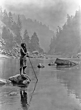
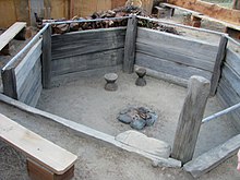
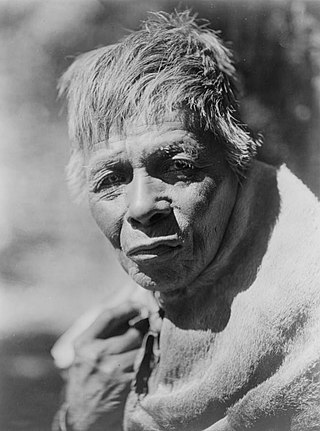
Hupa are a Native American people of the Athabaskan-speaking ethnolinguistic group in northwestern California. Their endonym is Natinixwe, also spelled Natinook-wa, meaning "People of the Place Where the Trails Return". The Karuk name was Kishákeevar / Kishakeevra. The majority of the tribe is enrolled in the federally recognized Hoopa Valley Tribe.

<span class="mw-page-title-main">Karuk language</span> Endangered language of California, US

Karuk or Karok is the traditional language of the Karuk people in the region surrounding the Klamath River, in Northwestern California. The name ‘Karuk’ is derived from the Karuk word káruk, meaning “upriver”.

Chilula were a Pacific Coast Athabaskan tribe speaking a dialect similar to the Hupa to the east and Whilkut to the south, who inhabited the area on or near Lower Redwood Creek, in Northern California, some 500 to 600 years before contact with Europeans.

<span class="mw-page-title-main">Hupa language</span> Athabaskan language of California, US

Hupa is an Athabaskan language spoken along the lower course of the Trinity River in Northwestern California by the Hoopa Valley Hupa (Na꞉tinixwe) and Tsnungwe/South Fork Hupa (Tse:ningxwe) and, before European contact, by the Chilula and Whilkut peoples, to the west.

Pacific Coast Athabaskan is a geographical and possibly genealogical grouping of the Athabaskan language family.

<span class="mw-page-title-main">Chimariko people</span>

The Chimariko are an indigenous people of California, who originally lived in a narrow, 20-mile section of canyon on the Trinity River in Trinity County in northwestern California.

<span class="mw-page-title-main">Chimariko language</span> Extinct language isolate of California, US

Chimariko is an extinct language isolate formerly spoken in northern Trinity County, California, by the inhabitants of several independent communities. While the total area claimed by these communities was remarkably small, Golla (2011:87–89) believes there is evidence that three local dialects were recognized: Trinity River Chimariko, spoken along the Trinity River from the mouth of South Fork at Salyer as far upstream as Big Bar, with a principal village at Burnt Ranch; South Fork Chimariko, spoken around the junction of South Fork and Hayfork Creek, with a principal village at Hyampom; and New River Chimariko, spoken along New River on the southern slopes of the Trinity Alps, with a principal village at Denny.

<span class="mw-page-title-main">Eel River Athapaskan peoples</span> Native American group in northwestern California, United States

The Eel River Athabaskans include the Wailaki, Lassik, Nongatl, and Sinkyone (Sinkine) groups of Native Americans that traditionally live in present-day Mendocino, Trinity, and Humboldt counties on or near the Eel River and Van Duzen River of northwestern California.

The Tolowa people or Taa-laa-wa Dee-ni’ are a Native American people of the Athabaskan-speaking ethno-linguistic group. Two rancherias still reside in their traditional territory in northwestern California. Those removed to the Siletz Reservation in Oregon are located there.

<span class="mw-page-title-main">Whilkut</span>

The Whilkut also known as "(Upper) Redwood Creek Indians" or "Mad River Indians" were a Pacific Coast Athabaskan tribe speaking a dialect similar to the Hupa to the northeast and Chilula to the north, who inhabited the area on or near the Upper Redwood Creek and along the Mad River except near its mouth, up to Iaqua Butte, and some settlement in Grouse Creek in the Trinity River drainage in Northwestern California, before contact with Europeans.

<span class="mw-page-title-main">Burnt Ranch, California</span> Census-designated place in California, United States

Burnt Ranch is a census-designated place (CDP) in Trinity County, California. It has a school and a post office. Its ZIP Code is 95527, and it is in area code 530. Its elevation is 1,502 feet (458 m). Its population is 250 as of the 2020 census, down from 281 from the 2010 census.

The New River, , is a 21.4-mile-long (34.4 km) tributary of the Trinity River in northern California. The river was named by miners during the California Gold Rush in the early 1850s. While prospecting west from earlier diggings on the upper Trinity River, they named the river due to it being a "new" place to search for gold.

<span class="mw-page-title-main">South Fork Trinity River</span> River in California, United States

The South Fork Trinity River is the main tributary of the Trinity River, in the northern part of the U.S. state of California. It is part of the Klamath River drainage basin. It flows generally northwest from its source in the Klamath Mountains, 92 miles (148 km) through Humboldt and Trinity Counties, to join the Trinity near Salyer. The main tributaries are Hayfork Creek and the East Branch South Fork Trinity River. The river has no major dams or diversions, and is designated Wild and Scenic for its entire length.

Copper Creek is a southern tributary of the Klamath River in the U.S. state of California. Arising in the Klamath Mountains, the creek drains a narrow watershed of about 120 square miles (310 km2). Historically, Copper Creek was the site of at least one Hupa Native American village, then was extensively mined for gold in the 1850s. The origin of the name comes from the peach-colored cliffs that line the lower few miles of the canyon.

Camp at Pardee's Ranch was a military post at Pardee's Ranch from 1858 until the end of the Bald Hills War for U.S. Army troops, California State Militia or California State Volunteers.

References

  1. Rowley, Max; Wooden, Margaret. "Big River: A Look at the South Fork of the Trinity by Max Rowley and Margaret Wooden". Humboldt Historian. 50 (1, Spring 2002): 15–23.
  2. "Chesbo family, Burnt Ranch. August 1921 1". oac.cdlib.org. Retrieved December 24, 2020.
  3. Hupa Language Dictionary - 2nd Edition, pages iii and 100
  4. Ararahih'urípih - Karuk Dictionary
  5. Ethnogeographic and Ethnosynosymic Data from Northern California Tribes, by C. Hart Merriam, pages 111-112, Edited by Robert Heizer, Archaeological Research Facility, Department of Anthropology, University of California, Berkeley, 1976
  6. Tsnungwe Place Names, by Tsnungwe Tribal Elders, 1994
  7. Map by C. Hart Merriam, Bureau of American Ethnology
  8. "Treaties between the Tsnungwe and United States Govt". www.dcn.davis.ca.us. Retrieved March 5, 2023.
  9. The ACCIP (Congressional Advisory Council on California Indian Policy) Recognition Report - Equal Justice for California, 1997
  10. "Tsnungwe Narrative". www.dcn.davis.ca.us. Retrieved March 5, 2023.
  11. "Tsnungwe Council – NAHC Digital Atlas". nahc.ca.gov. Retrieved March 5, 2023.
  12. California Athabascan Groups by Martin Baumhoff, Anthropological Records 16:5, University of California Press, Berkeley and Los Angeles, 1958
  13. "Hupa, Chilula and Whilkut" by William J. Wallace, Handbook of North American Indians, Volume 8: California, 1978
  14. Northern and Central California: Chimariko/Hupa, John Peabody Harrington papers, National Anthropological Archives, Smithsonian Institution. Interview with Saxey Kidd, 1928
  15. Ethnogeographic and Ethnosynosymic Data from Northern California Tribes, by C. Hart Merriam, pages 111-112, Edited by Robert Heizer, Archaeological Research Facility, Department of Anthropology, University of California, Berkeley, 1976