
Trinity County is a county in northwestern California. Trinity County is rugged, mountainous, heavily forested, and lies along the Trinity River within the Salmon and Klamath Mountains. It is also one of three counties in California with no incorporated cities.
Murphys, originally Murphys New Diggings then Murphy's Camp, is an unincorporated village located in the foothills of the Sierra Nevada mountains in Calaveras County, California, United States. The population was 2,213 at the 2010 census, up from 2,061 at the 2000 census.

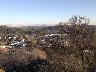
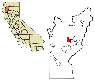
Weaverville is a census-designated place and the county seat of Trinity County, California in the United States. Its population is 3,667 as of the 2020 census, up from 3,600 from the 2010 census.

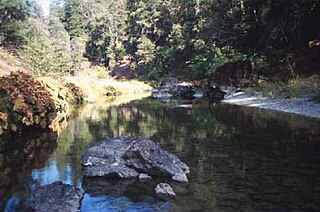
The Trinity River is a major river in northwestern California in the United States, and is the principal tributary of the Klamath River. The Trinity flows for 165 miles (266 km) through the Klamath Mountains and Coast Ranges, with a watershed area of nearly 3,000 square miles (7,800 km2) in Trinity and Humboldt Counties. Designated a National Wild and Scenic River, along most of its course the Trinity flows swiftly through tight canyons and mountain meadows.

Douglas City is a census-designated place (CDP) in Trinity County, California first settled during the California Gold Rush. Douglas City sits at an elevation of 2,152 feet (656 m). The ZIP Code is 96024. The community is inside area code 530. Its population is 868 as of the 2020 census, up from 713 from the 2010 census. The Whiskeytown–Shasta–Trinity National Recreation Area is nearby.

Trinity Lake, previously called Clair Engle Lake, is an artificial lake on the Trinity River formed by the Trinity Dam and located in Trinity County, California, United States. The dam was built by the U.S. Bureau of Reclamation. The lake's capacity is 2,447,650 acre⋅ft (3,019.13 GL), making it one of the largest reservoirs in California. The lake's surface is at 2,370 ft (720 m) above MSL. Trinity Lake captures and stores water for the Central Valley Project, which provides the Central Valley with water for irrigation and produces hydroelectric power. This lake is known for its many small arms, glassy inlets, and good water-skiing conditions.

Hyampom is a census-designated place (CDP) in Trinity County, California, US.

The Trinity Alps Wilderness is a 525,627-acre (212,714 ha) designated wilderness located in northern California, roughly between Eureka and Redding. It is jointly administered by Shasta-Trinity, Klamath, and Six Rivers National Forests. About 4,623 acres (1,871 ha) are administered by the Bureau of Land Management. The wilderness is located in the Salmon and Scott Mountains, subranges of the Klamath Mountains region. The high, granitic and ultramafic peaks of the eastern half of the wilderness area are known as the Trinity Alps. Granite peaks at the core of the area are known as the White Trinities, reddish ultramafic peaks in the southeast are known as the Red Trinities, and the forested mountains in the western half of the wilderness are known as the Green Trinities.
Junction City is a census-designated place (CDP) in Trinity County, California. Junction City sits at an elevation of 1,909 feet (582 m). Its population is 658 as of the 2020 census, down from 680 from the 2010 census. Junction City is located 8 miles (13 km) west of Weaverville. The Trinity River runs through the town and heads northwest from there. The ZIP Code is 96048. The community is inside area code 530.
The New River, , is a 21.4-mile-long (34.4 km) tributary of the Trinity River in northern California. The river was named by miners during the California Gold Rush in the early 1850s. While prospecting west from earlier diggings on the upper Trinity River, they named the river due to it being a "new" place to search for gold.

Graniteville is a small, unincorporated community and census-designated place (CDP) located in Nevada County, California, United States. The town sits on the San Juan ridge separating the Middle and South Forks of the Yuba River, approximately 26 miles (42 km) northeast of Nevada City. The elevation of Graniteville is 4,977 feet (1,517 m) above sea level.
Albeeville is a former settlement in Klamath County, now located in Humboldt County, California. Albeeville was located on Redwood Creek, within an easy day's travel from Fort Gaston. The post office was named for Joseph Porter Albee, its first postmaster, who was murdered by Indians, and the Albeeville post office burned in November 1863.
Cherokee is a former gold mining community in Nevada County, California. As explained below, it has also been known as Patterson, Melrose and Tyler. It is located on the San Juan Ridge about 4 miles east of North San Juan. Its elevation is 2,516 ft (767 m) above sea level.
Little York is the name of one of the first mining towns established in Nevada County, as well as the name of the township in which it was situated. The town was located on the Lowell Ridge between Steephollow Creek and the Bear River, about 13 miles east of Nevada City and about 1 mile southwest of Dutch Flat at an elevation of about 2800 ft.
Lowell Hill was a mining town located on the ridge between Steephollow Creek and the Bear River, about 10 miles east of Nevada City and about 4 miles north of Alta, as the crow flies. It was part of Little York Township and the center of what was generally called the Lowell Hill mining district, a rich channel of gold bearing ore that ran from around Remington Hill to the north down to the Bear River and then crossed over towards Dutch Flat and Alta.

Visalia, California, commonly known in the 1850s as Four Creeks, is the oldest continuously inhabited inland European settlement between Stockton and Los Angeles. The city played an important role in the American colonization of the San Joaquin Valley as the county seat of Old Tulare County, an expansive region comprising most if not all of modern-day Fresno, Kings, and Kern counties.
The Tsnungwe or Tsanunghwa are a Native American people indigenous to the modern areas of the lower South Fork Trinity River, Willow Creek, Salyer, Burnt Ranch and New River along the Trinity River in Trinity and Humboldt County in California. The Tsnungwe were a bilingual Hupa-Chimariko-speaking people and are known by the Hupa-speaking peoples as tse:ning-xwe. The primary language was the Tsnungwe dialect of Hupa, and the secondary language was Chimariko, although spoken with a Hupa accent.
Helena is a ghost town in unincorporated Trinity County, California, United States. It is located on the North Fork of the Trinity River, 10 miles (16 km) west-northwest of Weaverville. State Route 299 runs right past the former town to the south; East Fork Road connects the highway to Helena.
Hayfork Creek is a tributary of the South Fork Trinity River in Northern California in the United States. At over 50 miles (80 km) long, it is the river's longest tributary and is one of the southernmost streams in the Klamath Basin. It winds through a generally steep and narrow course north then west through the forested Klamath Mountains, but also passes through the Hayfork and Hyampom Valleys, which are the primary agricultural regions of Trinity County.
La Laguna was a gold mining town in New Mexico Territory, now Yuma County, Arizona. It was in existence for a short time from 1860 to 1862. The town was a steamboat landing 20 miles above Yuma, Arizona on the Colorado River. It had a few merchants and a ferry across the Colorado River that served placer miners in the vicinity. When the La Paz gold rush began, La Laguna began to decline and it was soon replaced by Castle Dome Landing, 15 miles to the north, following the discovery of gold in the Castle Dome Mountains. It remained for a time as the site of a store and a ranch, belonging to Jose Redondo, one of the first to mine gold at La Paz.

