
The peanut, also known as the groundnut, goober (US), pindar (US) or monkey nut (UK), is a legume crop grown mainly for its edible seeds. It is widely grown in the tropics and subtropics, important to both small and large commercial producers. It is classified as both a grain legume and, due to its high oil content, an oil crop. World annual production of shelled peanuts was 44 million tonnes in 2016, led by China with 38% of the world total. Atypically among legume crop plants, peanut pods develop underground (geocarpy) rather than above ground. With this characteristic in mind, the botanist Carl Linnaeus gave peanuts the specific epithet hypogaea, which means "under the earth".

Trinity County is a county located in the northwestern portion of the U.S. state of California. Trinity County is rugged, mountainous, heavily forested, and lies along the Trinity River within the Salmon and Klamath Mountains. It is also one of three counties in California with no incorporated cities.

Weedpatch is an unincorporated community and census-designated place (CDP) in Kern County, California, United States. Weedpatch is 10 miles (16 km) south-southeast of Bakersfield. It is considered to be one of the poorest areas in Kern County. As of the 2010 census it had a population of 2,658.

Weaverville is a town in Buncombe County, North Carolina, United States. The population was 4,567 at the 2020 census. It is part of the Asheville Metropolitan Statistical Area.

Peanut butter is a food paste or spread made from ground, dry-roasted peanuts. It commonly contains additional ingredients that modify the taste or texture, such as salt, sweeteners, or emulsifiers. Consumed in many countries, it is the most commonly used of the nut butters, a group that also includes cashew butter and almond butter.

State Route 3 is a state highway in the U.S. state of California that serves Trinity and Siskiyou counties. It runs from SR 36 north along the shore of Trinity Lake, Fort Jones and Etna. The route then approaches Yreka, intersecting with Interstate 5 (I-5), and turns east to Montague. The road was numbered SR 3 in 1964, and most of it has been part of the state highway system since 1933.

Douglas City is an unincorporated community in Trinity County, California first settled during the California Gold Rush. Douglas City sits at an elevation of 2,152 feet (656 m). The ZIP Code is 96024. The community is inside area code 530. Its population is 868 as of the 2020 census, up from 713 from the 2010 census. For statistical purposes, the United States Census Bureau has defined Douglas City as a census-designated place (CDP). The Whiskeytown–Shasta–Trinity National Recreation Area is nearby.
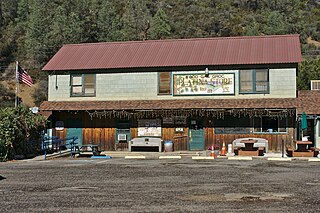
Platina is a small unincorporated community in Shasta County, California, approximately and equidistantly 40 miles (64 km) west of Redding and Red Bluff. Its population is 13 as of the 2020 census. Its ZIP code is 96076. Wired telephone numbers follow the pattern 530-352-xxxx.
Denny, California refers to two little mining settlements named Denny in northwestern Trinity County, one in the upper New River watershed within the Trinity Alps Wilderness Area and the other twenty miles downstream along a one-way county roadway.
Albeeville is a former settlement in Klamath County, now located in Humboldt County, California. Albeeville was located on Redwood Creek, within an easy day's travel from Fort Gaston. The post office was named for Joseph Porter Albee, its first postmaster, who was murdered by Indians, and the Albeeville post office burned in November 1863.

Weaver, or Weaverville, is a former gold mining town, now a deserted ghost town, in Yavapai County, Arizona, United States. All that remains are some rusting mining machinery, a partially restored cemetery, and the ruins of a stone house.
Helena is a ghost town in unincorporated Trinity County, California, United States. It is located on the North Fork of the Trinity River, 10 miles (16 km) west-northwest of Weaverville. State Route 299 runs right past the former town to the south; East Fork Road connects the highway to Helena.
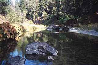
Hayfork Creek is a tributary of the South Fork Trinity River in Northern California in the United States. At over 50 miles (80 km) long, it is the river's longest tributary and is one of the southernmost streams in the Klamath Basin. It winds through a generally steep and narrow course north, then west through the forested Klamath Mountains, but also passes through the Hayfork and Hyampom Valleys, which are the primary agricultural regions of Trinity County.

Trotters is an unincorporated community in Golden Valley County, North Dakota, United States. Trotters is located on North Dakota Highway 16, 28.3 miles (45.5 km) north of Beach. The community did not receive telephone service until 1972, and Highway 16, its only road, was paved in the 1980s.
Branson City or Branson is a ghost town in San Diego County, California. It lies at an elevation of 3996 feet. It is located on State Highway 78 at its junction with Pine Hills Road, about one mile west of Julian.
Edward Bernard Peter Buck is an American convicted felon, Democratic Party donor, and businessman. A former model and actor, he made a significant amount of money running and selling the data service company Gopher Courier. He became involved in politics after the election of Evan Mecham as Governor of Arizona in 1986; Buck, an Arizona resident, led the effort to recall him from office, accusing him of racism and corruption. The experience led Buck to change his party affiliation from Republican to Democrat, and he has since donated heavily to Democratic politicians. In 2007, he ran an unsuccessful campaign for the city council of West Hollywood, California.
Beegum, also known as Bee Gum, is a defunct town which was located in an unincorporated area of Tehama and Shasta counties, in the U.S. state of California. In the early 1900s, it was a mining town in the Harrison Gulch mining district.
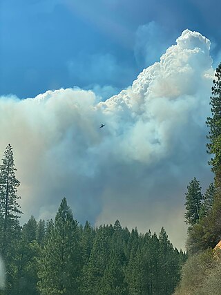
The McFarland Fire was a wildfire that burned in the Shasta-Trinity National Forest north of Wildwood in Trinity County, Shasta County, and Tehama County, California in the United States. Started by a lightning strike, the fire was first reported on July 29, 2021 on McFarland Ridge south of Highway 36. As of September 16, 2021, the fire had burned 122,653 acres (49,636 ha) and destroyed 46 structures.
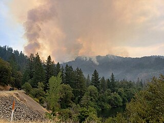
The Monument Fire was a wildfire west of Big Bar in Shasta-Trinity National Forest, Trinity County, California in the United States. The fire, which was started by a lightning strike, was first reported on July 30, 2021. The communities of Big Flat, Big Bar, Del Loma, and Cedar Flat are evacuated. Highway 299 is closed in the area. The fire has destroyed four structures, including three homes. As of the evening of October 27, the fire has burned 223,124 acres (90,295 ha) and is fully contained.

Lindsey Patrice Horvath is an American politician, advertising executive, and activist who is a member of the Los Angeles County Board of Supervisors for the 3rd District, which covers the San Fernando Valley, and is the Chair of Los Angeles County. She was previously a Councilmember for West Hollywood, California and was twice the mayor.


