Related Research Articles

Bodmin is a civil parish and historic town in Cornwall, England, United Kingdom. It is situated south-west of Bodmin Moor.

Bodmin Moor is a granite moorland in northeastern Cornwall, England. It is 208 square kilometres (80 sq mi) in size, and dates from the Carboniferous period of geological history. It includes Brown Willy, the highest point in Cornwall, and Rough Tor, a slightly lower peak. Many of Cornwall's rivers have their sources here. It has been inhabited since at least the Neolithic era, when primitive farmers started clearing trees and farming the land. They left their megalithic monuments, hut circles and cairns, and the Bronze Age culture that followed left further cairns, and more stone circles and stone rows. By medieval and modern times, nearly all the forest was gone and livestock rearing predominated.

North Cornwall is an area of Cornwall, England, United Kingdom. It is also the name of a former local government district, which was administered from Bodmin and Wadebridge 50.516°N 4.835°W. Other towns in the area are Launceston, Bude, Padstow, and Camelford.

North Cornwall is a constituency represented in the House of Commons of the UK Parliament by Scott Mann, a Conservative since the 2015 general election. Like all British constituencies, the seat elects one Member of Parliament (MP) by the first past the post system of election at least every five years. The seat was created in 1918. Since 1950, the constituency has been held by MPs from either the Conservative Party or the Liberal Democrats.
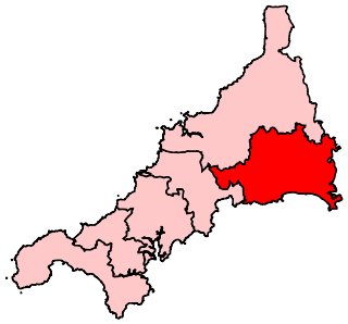
South East Cornwall is a constituency represented in the House of Commons of the UK Parliament since 2010 by Sheryll Murray, a Conservative.
St Teath is a civil parish and village in north Cornwall, England, in the United Kingdom.

The Camel Trail is a permissive cycleway in Cornwall, England, United Kingdom, that provides a recreational route for walkers, runners, cyclists and horse riders. The trail is flat ; running from Padstow to Wenford Bridge via Wadebridge and Bodmin, it is 17.3 miles (27.8 km) long and used by an estimated 400,000 users each year generating an income of approximately £3 million a year.
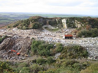
De Lank Quarries is a 54-acre geological Site of Special Scientific Interest in St Breward parish, north Cornwall, England, UK, notified in 1994. The quarry takes its name from the De Lank river.

Tuckingmill is a village in Cornwall, England, United Kingdom, which is in the civil parish of Camborne. Tucking Mill was the Cornish term for a fulling mill which was where homespun cloth was dipped, cleansed and dressed. There is a mention of a fulling mill in this region as early as 1250. The ecclesiastical parish of Tuckingmill was constituted in 1845, being carved out of a western section of the parish of Illogan and an eastern section of Camborne parish. It covers 1,300 acres (5.3 km2).

St Breward is a civil parish and village in Cornwall, England, United Kingdom. It is on the western side of Bodmin Moor, about 6 miles (10 km) north of Bodmin. At the 2011 census the parish population including Cooksland and Fentonadle was 919.

The Par River, also known as the Luxulyan River is a river draining the area north of St Blazey in Cornwall, in the United Kingdom.

Withiel is a civil parish and village in mid Cornwall, England, United Kingdom. The parish of Withiel is between the parishes of St Breock, Lanivet, Roche and St Wenn. The name Withiel comes from the Cornish word Gwydhyel, meaning "wooded place". The parish contains the hamlets of Withielgoose, Retire and Tregawne; the parish had a total population of about 300 in 1824.

Rough Tor, or Roughtor, is a tor on Bodmin Moor, Cornwall, United Kingdom. The site is composed of the tor summit and logan stone, a neolithic tor enclosure, a large number of Bronze Age hut circles, and some contemporary monuments.

The De Lank River is a small river in north Cornwall, England. It is a tributary of the River Camel and is approximately nine miles (14.5 km) long from its source on Bodmin Moor to its confluence with the Camel two miles (3 km) south of St Breward.
Lank is a settlement in Cornwall, England, United Kingdom. It is situated approximately one mile (1.6 km) south of St Breward and six miles (10 km) east-northeast of Wadebridge in St Breward civil parish. It is in the civil parish of Blisland.

Wenfordbridge, or Wenford Bridge, is a hamlet some 6 miles (9.7 km) north of Bodmin and on the western flank of Bodmin Moor, in Cornwall, England, UK. It takes its name from an old granite bridge over the River Camel, and lies on the border between the parishes of St Breward and St Tudy.
Penpont is a hamlet in the parish of St Breward, in north Cornwall, England, UK, in the Camel Valley.

Trevenning is a hamlet south of Michaelstow, Cornwall, England, UK.
Tywardreath Highway is a hamlet in Cornwall, England, located near the village of St Blazey.
References
- ↑ "008PDZF The Old Reading Room Tuckingmill St Breward Bodmin Cornwall PL30 4PQ". planning.cornwall.gov.uk. Retrieved 8 October 2017.
- ↑ "The Old Reading Room". theoldreadingroom.co.uk. Retrieved 8 December 2019.
- ↑ "008PDXFGBU000 Jordan Cottage Tuckingmill St Breward Bodmin Cornwall PL30 4PQ". planning.cornwall.gov.uk. Retrieved 8 October 2017.
Coordinates: 50°34′08″N4°41′53″W / 50.569°N 4.698°W
| This Cornwall location article is a stub. You can help Wikipedia by expanding it. |