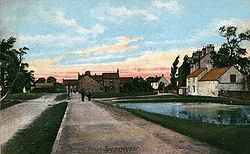
Tudhoe

Last updated

Tudhoe
Tudhoe Methodist Church - geograph.org.uk - 2479615.jpg
Durham UK location map.svg
Red pog.svg
Tudhoe
Location within County Durham
Population8,976 (2011.Ward) [1]
OS grid reference NZ265349
Civil parish
Unitary authority
Ceremonial county
Region
Country England
Sovereign state United Kingdom
Post town SPENNYMOOR
Postcode district DL16
Police Durham
Fire County Durham and Darlington
Ambulance North East
UK Parliament
List of places
UK
England
County Durham
54°42′32″N1°35′06″W / 54.709°N 1.585°W / 54.709; -1.585
Tudhoe Village, Old Postcard.jpg

Tudhoe is a village in the civil parish of Spennymoor, in County Durham, England. It lies just outside Spennymoor, a short distance to the west of the Great North Road. Tudhoe lay at the centre of a network of roads: one ran to Durham by way of Sunderland Bridge and Croxdale, another to Kirk Merrington, a third to Bishop Auckland, a fourth to Whitworth and Byers Green, and a fifth across a ford to Brancepeth Castle and village on the far side of the river. All except the Brancepeth road are shown on the 1768 map of County Durham by Thomas Jefferys.

Contents

Tudhoe is now dwarfed by Spennymoor, an industrial town that grew up around the Tudhoe iron works in the 19th century. The modern town of Spennymoor lies only a few fields from Tudhoe, but the contours are such that it cannot be seen from most of the village, and Tudhoe today gives the impression that it is still an isolated country village.

For most of its history, Tudhoe has been in the parish of Brancepeth. The parish church of St Brandon's, dating from the 16th century, was one of the finest village churches in County Durham until its destruction by fire in 1998. Brancepeth lies across the River Wear from Tudhoe; there has never been a bridge, and the ford was not an easy one. In winter, it was often impassable, and Tudhoe baptisms, weddings and burials then took place at Whitworth. Because of this, Tudhoe was always seen (from Brancepeth) as an isolated outpost. Tudhoe's own Anglican churches, Holy Innocents and St David's, were not built until 1866 and 1880, respectively, though there is a large Catholic church, dedicated to St. Charles Borromeo, which was founded in 1858.

Tudhoe was renowned as a mining village until the end of the 20th century. Until the closure of the mines, the wealthy Colliery Masters took up residence in a grand mansion known as The Loggins, which stands in several acres of its own land and overlooks the area.

Governance

Tudhoe was formerly a township and chapelry in the parish of Brancepeth, [2] in 1866 Tudhoe became a separate civil parish, on 1 April 1937 the parish was abolished and merged with Spennymoor. [3] In 1931 the parish had a population of 6865. [4]

Related Research Articles

<span class="mw-page-title-main">Willington, County Durham</span> Human settlement in England

Willington is a village and former civil parish, now in the parish of Greater Willington, in County Durham and the ceremonial county of Durham, England. Willington stands in the foothills of the Pennines and near the River Wear close to Crook, Bishop Auckland and Durham.

<span class="mw-page-title-main">Spennymoor</span> Town and civil parish in England

Spennymoor is a town and civil parish in County Durham, England. It is south of the River Wear and is 7 mi (11 km) south of Durham. The civil parish includes the villages of Kirk Merrington, Middlestone Moor, Byers Green and Tudhoe.

<span class="mw-page-title-main">Carlton, South Yorkshire</span> Village in South Yorkshire, England

Carlton is a village in the Metropolitan Borough of Barnsley in South Yorkshire, England. It is situated between the villages of Athersley and Royston. The village is split in two with one half in the Monk Bretton ward and the rest in the Royston ward of the Barnsley MBC. It was built up on coking and coal mining industries and now has one of the largest industrial estates within the surrounding area. In the industrial estate lies a glass recycling plant, called Rexam. To its east stands the Mr Kipling cake factory, owned by Premier Foods. Until 1974 it was in the West Riding of Yorkshire.

Whitworth was a civil parish in County Durham, in England, centred on Whitworth Hall. It was one of several parishes abolished in 1937 to create the parish of Spennymoor. Whitworth Hall is on the road between Spennymoor and Brancepeth, and is close to Tudhoe. The house was in former times the home of the Shafto family, whose most famous member was Bobby Shafto, subject of a famous English nursery rhyme.

<span class="mw-page-title-main">Benfieldside</span> Human settlement in England

Benfieldside is a settlement in County Durham, England. Although not a village in its own right, it is signposted and locally known. The name 'Benfieldside' survives in Benfieldside Road, a school of that name, the local tennis club and the church. Its post office no longer exists, though one remains in the village of Shotley Bridge. The Parish Church is dedicated to St. Cuthbert and is situated on Church Bank. The area is situated directly to the north of Consett, to which it is effectively attached.

<span class="mw-page-title-main">Byers Green</span> Human settlement in England

Byers Green is a village and former civil parish, now in the parish of Spennymoor, in the County Durham district, in the ceremonial county of Durham, England. It is situated to the north of Bishop Auckland, between Willington and Spennymoor, and a short distance from the River Wear. It has a population of 672.

<span class="mw-page-title-main">Iveston</span> Human settlement in England

Iveston is a village in County Durham, England. It is situated a short distance to the east of Consett. Housing in the area consists of a mixture of traditional cottages and large, newer residential properties. Historically, farming and mining formed the chief sources of employment in the village. In 1931 the parish had a population of 6395.

<span class="mw-page-title-main">Hett, County Durham</span> Human settlement in England

Hett is a village and former civil parish, now in the parish of Croxdale and Hett, in the County Durham district, in the ceremonial county of Durham, England. It is situated a few miles south of Durham. Hett is largely surrounded by farmland. To the south, rape fields are predominant while at the northern end, cattle are grazed all year round. To the north-west of Hett lies Sunderland Bridge, a small hamlet with a population of under 50 people (2004). Hett contains a small pond, village hall and a football pitch.

<span class="mw-page-title-main">Newfield, Bishop Auckland</span> Human settlement in England

Newfield is a village and former civil parish in the County Durham district, in the ceremonial county of Durham, England. It is situated to the south of Willington, near Bishop Auckland. In the 2001 census Newfield had a population of 368.

<span class="mw-page-title-main">Haughton-le-Skerne</span> Human settlement in England

Haughton-le-Skerne is a village in the borough of Darlington in the ceremonial county of Durham, England. It is situated in the north east of Darlington. The village lies to the west of the River Skerne. At the centre of the village green, is the main road towards Darlington town centre going across the river, south of the church. There used to be a linen mill on the riverbank on the east side of the village. Part of the mill leat can still be seen today.

<span class="mw-page-title-main">Helmington Row</span> Human settlement in England

Helmington Row is a small village in County Durham, England. It is situated between Crook and Willington, about 7 miles south-west of Durham and 3 miles north-north-west of Bishop Auckland.

<span class="mw-page-title-main">Middlestone</span> Village in United Kingdom

Middlestone is a village and former civil parish in the County Durham district, in the ceremonial county of Durham, England. It is situated to the south of Spennymoor, near Kirk Merrington. In the 2001 census Middlestone had a population of 67.

<span class="mw-page-title-main">Neville's Cross</span> Human settlement in England

Neville's Cross is a place in the civil parish of the City of Durham, in County Durham, England. It is also a ward of Durham with a population taken at the 2011 census of 9,940. It is situated on the A167 trunk road to the west of the centre of Durham.

<span class="mw-page-title-main">Broomhaugh</span> Human settlement in England

Broomhaugh is a village and former civil parish, now in the parish of Broomhaugh and Riding, in Northumberland, England. It is situated between Hexham and Newcastle upon Tyne, to the south of the River Tyne near Riding Mill, and adjacent to the A695 road. In 1951 the parish had a population of 228.

<span class="mw-page-title-main">Fulwell, Sunderland</span> Human settlement in England

Fulwell is an affluent area and former civil parish in the Sunderland district, in the county of Tyne and Wear, England. The parish was abolished in 1928 as a result of the Sunderland Corporation Act 1927, and the area incorporated into the former County Borough of Sunderland. It borders Seaburn, Southwick, Monkwearmouth, and Roker, and the district border between Sunderland and South Tyneside. Fulwell ward, including South Bents and Seaburn, is the least socially deprived of the city's 25 wards. Until 1974 it was in County Durham.

<span class="mw-page-title-main">East Rainton</span> Human settlement in England

East Rainton is a village and former civil parish, now in the parish of Hetton, in the Sunderland district, in the county of Tyne and Wear, England. It is situated alongside the A690 road between Sunderland and Durham, near Houghton-le-Spring. In 1931 the parish had a population of 1711. East Rainton was formerly a township and chapelry in the parish of Houghton-le-Spring, from 1866 East Rainton was a civil parish in its own right, on 1 April 1937 the parish was abolished to form Hetton, part also went to Houghton le Spring.

<span class="mw-page-title-main">Webheath</span> Human settlement in England

Webheath is a district of Redditch, in Worcestershire, England. The district neighbours Batchley, Headless Cross and the village of Callow Hill. It is also near Feckenham and Astwood Bank.

<span class="mw-page-title-main">Westerton, County Durham</span> Human settlement in England

Westerton is a village and former civil parish in the County Durham district, in the ceremonial county of Durham, England. In the 2001 census Westerton had a population of 44. It is situated between Bishop Auckland and Spennymoor. It sits on top of a hill which is one of the highest points in County Durham, and is the location of an observatory built for Thomas Wright, who was the first person to suggest that the Milky Way consisted of a flattened disk of stars. The observatory is known today as "Wright's Folly".

<span class="mw-page-title-main">Harton, South Shields</span> Human settlement in England

Harton is a suburban area of South Shields, South Tyneside, Tyne and Wear, England. It was historically a village, however as the urban area grew it merged with its adjacent villages to become part of the town. Some of the original village buildings are still intact today, such as St Peter's Church. Until 1974 it was in County Durham.

<span class="mw-page-title-main">Sunderland Bridge (village)</span> Human settlement in England

Sunderland Bridge is a village and former civil parish, now in the parish of Croxdale and Hett, in the County Durham district, in the ceremonial county of Durham, England. It is about 3 miles (4.8 km) south of Durham city. In 1961 the parish had a population of 907.

References

  1. "Spennymoor ward population 2011" . Retrieved 21 July 2015.
  2. "History of Tudhoe, in Sedgefield and County Durham". A Vision of Britain through Time . Retrieved 5 April 2024.
  3. "Relationships and changes Tudhoe CP/Tn through time". A Vision of Britain through Time. Retrieved 5 April 2024.
  4. "Population statistics Tudhoe CP/Tn through time". A Vision of Britain through Time. Retrieved 5 April 2024.