
The Province of Natal, commonly called Natal, was a province of South Africa from May 1910 until May 1994. Its capital was Pietermaritzburg. During this period rural areas inhabited by the black African population of Natal were organized into the bantustan of KwaZulu, which was progressively separated from the province, becoming partially autonomous in 1981. Of the white population, the majority were English-speaking people of British descent, causing Natal to become the only province to vote "No" to the creation of a republic in the referendum of 1960, due to very strong monarchist, anti-republican, pro-British Commonwealth, and secessionist sentiment. In the latter part of the 1980s, Natal was in a state of violence that only ended with the first non-racial election in 1994.

KwaZulu-Natal is a province of South Africa that was created in 1994 when the Zulu bantustan of KwaZulu and Natal Province were merged. It is located in the southeast of the country, enjoying a long shoreline beside the Indian Ocean and sharing borders with three other provinces, and the countries of Mozambique, Eswatini and Lesotho. Its capital is Pietermaritzburg, and its largest city is Durban. It is the second-most populous province in South Africa, with slightly fewer residents than Gauteng.

The Tugela River is the largest river in KwaZulu-Natal Province, South Africa. It is one of the most important rivers of the country.

KwaZulu was a semi-independent bantustan in South Africa, intended by the apartheid government as a homeland for the Zulu people. The capital was moved from Nongoma to Ulundi in 1980.
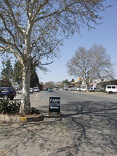
Winterton is a small town situated on the banks of the Tugela River in the foothills of the Drakensberg mountains, KwaZulu-Natal, South Africa. It was founded in 1905 by and the when the [wintercolony]|Natal Government]] built a weir across the Little Tugela River. The town later changed its name to Winterton in honour the secretary for agriculture, J WINTER. Winterton is a small town with only a primary school. It is close to the Second Boer War battle sites of Battle of Vaal Krantz and Spioenkop.

Mandeni is a town in Ilembe District Municipality in the KwaZulu-Natal province of South Africa.

Blood River is situated in KwaZulu-Natal, South Africa. This river has its sources in the hills south-east of Utrecht; leaving the highlands it is joined by two important tributaries that originate in the Schurveberg, after which it flows meandering through a sandy plain. The Blood River is a tributary of the Buffalo River, which is a tributary of the Tugela River which it joins from the north-east.
The Mooi River is a river in KwaZulu-Natal Province, South Africa. It rises in the Mkomazi Nature Reserve in the Drakensberg Mountains, and empties into the Tugela River near Muden. The town of Mooi River lies on the river.

The Zulu Kingdom, sometimes referred to as the Zulu Empire or the Kingdom of Zululand, was a monarchy in Southern Africa that extended along the coast of the Indian Ocean from the Tugela River in the south to Pongola River in the north.
The Diocese of Zululand is a diocese of the Anglican Church of Southern Africa which covers the part of the South African province of KwaZulu-Natal that lies to the northeast of the Buffalo and Tugela Rivers. It is divided in ten archdeaconries.

The Bushman's River is an east to north-easterly flowing tributary of the Tugela River, in the KwaZulu-Natal province of South Africa. It rises in the Drakensberg Mountain range, with its upper catchment in the Giant's Castle Game Reserve, north of the Giant's Castle promontory. It feeds the Wagendrift Dam and then flows past the town of Estcourt to join the Tugela River near the town of Weenen.
The Bloukrans River (KwaZulu-Natal) originates in the Emangosini foothills of the Njesuthi Drakensberg, in the KwaZulu-Natal province of South Africa. It proceeds in a north-easterly direction, passing the village of Frere, until it joins the Tugela River. The river and its tributaries are mostly undammed, though limited irrigation occurs from its upper reaches. Its original Dutch name Blaauwekrans referred to bluish cliff faces present in the area.
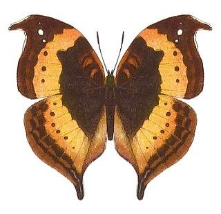
Precis tugela, the African leaf butterfly or eared commodore, is a butterfly of the family Nymphalidae. It is found in eastern and southern Africa, ranging from Ethiopia to South Africa. It is commonly included in the genus Precis instead of Junonia.

The Buffalo River is the largest tributary of the Tugela River in South Africa. Its source is in Majuba Hill, "Hill of Doves" in Zulu language, located northeast of Volksrust, close to the Mpumalanga / KwaZulu-Natal border. It follows a southerly route into KwaZulu-Natal past Newcastle then turns southeast past Rorke's Drift, before joining the Tugela River at Ngubevu near Nkandla. During the nineteenth century it formed part of the boundary between the Colony of Natal and Zululand.
St Lucia is a settlement in Umkhanyakude District Municipality in the KwaZulu-Natal province of South Africa. The small town is mainly a hub for the iSimangaliso Wetland Park.
Tugela is a town in Ilembe District Municipality in the KwaZulu-Natal province of South Africa.

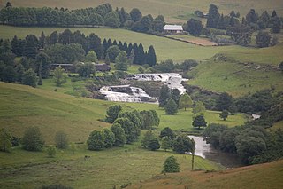
Spion Kop is a mountain in the province of KwaZulu-Natal, South Africa. It is located near the town of Ladysmith, 27 km to the WSW and about 2.5 km to the north of the Spioenkop Dam, a reservoir for the waters of the Tugela River.
Tugela is a river in KwaZulu-Natal Province, South Africa

The Piet Retief Delegation massacre was the 1838 killing of 100 Voortrekkers by the Zulu king Dingane in what is now KwaZulu-Natal, South Africa. The Voortrekkers, led by Piet Retief, migrated into Natal in 1837 and negotiated a land treaty in February 1838 with Dingane. Upon realizing the ramifications of the imposed contract, Dingane betrayed the Voortrekkers, killing the delegation including Retief on 6 February 1838. The land treaty was later found in Retief's possession. It gave the Voortrekkers the land between the Tugela River and Port St. Johns. This event eventually led to the Battle of Blood River and the eventual defeat of Dingane.

The KwaZulu-Natal North Coast is a region on the northern coast of KwaZulu-Natal, South Africa. It stretches from Thukela Mouth in the north to Ballito in the south. The coast is governed by the iLembe District Municipality.


