Tukgahgo Mountain

Last updated
Tukgahgo Mountain

Tukgahgo1.jpg

Mount Tukgahgo in early fall.
Highest point
Elevation 4,675 ft (1,425 m) [1]
Coordinates 59°18′01″N135°37′46″W / 59.30028°N 135.62944°W / 59.30028; -135.62944
Geography
Location Haines Borough, Alaska, U.S.
Parent range Takshanuk Mountains
Topo map USGS Skagway (B-2)
Climbing
First ascent Unknown
Easiest route Scramble

Tukgahgo Mountain (TUG-a-ho) is located in the Takshanuk Mountains with a peak elevation of 4,675 feet (1,425 m) in the U.S. state of Alaska. It is situated 6.6 miles (10.6 km) north of Haines, 3.5 miles (5.6 km) to the southwest of Chilkoot Lake, and 16 miles (26 km) to the southwest of Skagway. [2] It is one of eight peaks in Haines Borough. [3] Geological investigations of the veins in the mountain have revealed silver, gold, platinum, and palladium mineralization, derived from mid-Cretaceous events.

Takshanuk Mountains

The Takshanuk Mountains are a mountain range in Southeast Alaska, United States that separate the Chilkoot and Chilkat watersheds and also form the northern portion of the Chilkat Peninsula.

U.S. state constituent political entity of the United States

In the United States, a state is a constituent political entity, of which there are currently 50. Bound together in a political union, each state holds governmental jurisdiction over a separate and defined geographic territory and shares its sovereignty with the federal government. Due to this shared sovereignty, Americans are citizens both of the federal republic and of the state in which they reside. State citizenship and residency are flexible, and no government approval is required to move between states, except for persons restricted by certain types of court orders. Four states use the term commonwealth rather than state in their full official names.

Alaska State of the United States of America

Alaska is a U.S. state in the northwest extremity of North America, just across the Bering Strait from Asia. The Canadian province of British Columbia and territory of Yukon border the state to the east, its most extreme western part is Attu Island, and it has a maritime border with Russia to the west across the Bering Strait. To the north are the Chukchi and Beaufort seas—southern parts of the Arctic Ocean. The Pacific Ocean lies to the south and southwest. It is the largest U.S. state by area and the seventh largest subnational division in the world. In addition, it is the 3rd least populous and the most sparsely populated of the 50 United States; nevertheless, it is by far the most populous territory located mostly north of the 60th parallel in North America: its population—estimated at 738,432 by the United States Census Bureau in 2015— is more than quadruple the combined populations of Northern Canada and Greenland. Approximately half of Alaska's residents live within the Anchorage metropolitan area. Alaska's economy is dominated by the fishing, natural gas, and oil industries, resources which it has in abundance. Military bases and tourism are also a significant part of the economy.

Contents

Geography

Takshanuk Mountains Range TakshanukMountains1.jpg
Takshanuk Mountains Range

Tukgahgo, an indigenous name given by the Tlingits, was recorded by geologist Eugene C. Robertson and published by the United States Geological Survey (USGS) in 1952. [2] [4] In order to climb the Tukgahgo Mountain and reach the summit, detailed information needs to be ascertained from the topographic maps published by USGS and the Skagway B-2 USGS quadrangle map. [3] A part of the Coast Mountains, Tukgahgo is situated 3.5 miles (5.6 km) from Chilkoot, while Skagway is 16 miles (26 km) to the southwest. Vanderbilt Point is located 3 miles (4.8 km) west of Tukgahgo's summit. The head of Shakuseyi Creek is on the east slope of the mountain. [5]

United States Geological Survey scientific agency of the United States government

The United States Geological Survey is a scientific agency of the United States government. The scientists of the USGS study the landscape of the United States, its natural resources, and the natural hazards that threaten it. The organization has four major science disciplines, concerning biology, geography, geology, and hydrology. The USGS is a fact-finding research organization with no regulatory responsibility.

Coast Mountains

The Coast Mountains are a major mountain range in the Pacific Coast Ranges of western North America, extending from southwestern Yukon through the Alaska Panhandle and virtually all of the Coast of British Columbia south to the Fraser River. The mountain range's name derives from its proximity to the sea coast, and it is often referred to as the Coast Range. The range includes volcanic and non-volcanic mountains and the extensive ice fields of the Pacific and Boundary Ranges, and the northern end of the volcanic system known as the Cascade Volcanoes. The Coast Mountains are part of a larger mountain system called the Pacific Coast Ranges or the Pacific Mountain System, which includes the Cascade Range, the Insular Mountains, the Olympic Mountains, the Oregon Coast Range, the California Coast Ranges, the Saint Elias Mountains and the Chugach Mountains. The Coast Mountains are also part of the American Cordillera—a Spanish term for an extensive chain of mountain ranges—that consists of an almost continuous sequence of mountain ranges that form the western backbone of North America, Central America, South America and Antarctica.

Chilkoot Lake lake in United States of America

The Chilkoot Lake, in the Tlingit Indians region of Alaska, is also spelt Chilcoot Lake. Its other local names are the Akha Lake and Tschilkut S(ee), meaning “Chilkoot Lake”. It is in Haines Borough, Alaska. Chilkoot also means "big fish". The lake has a ‘Recreation Site’ at its southern end near the outlet to the Chilkoot River, which is set amidst the Sitka spruce trees. Chilkoot River flows from the lake for a short length and debouches into the Lutak Channel at the head of the Chilkoot inlet near Haines. Chilkoot village, a settlement of Chilkoot Indians existed at the outlet of the lake, which was called Tschilkut or Tananel or Chilcoot; the lake is named after this village. This village is now a camping area developed by the State Parks and Outdoor Recreation Division of the Alaska Department of Natural Resources. The lake is a popular location for Kayaking.

Geology

New geological findings close to Tukgahgo and the eastern ridge have been reported. In 1991, when the sampling was carried out by geologists, a rock formation 2,500 ft (760 m) to the southwest of Tukgahgo Mountain on the northwest trending Chilly peak (elevation 4,520 ft (1,380 m) [1] was initially given the informal title "Chilly." [6] The geologic formations of the area consist of metabasalts and amphibolites, which are enclosed as roof pendants within the hornblende diorite, granodiorite and monzonite. The intrusive rocks are inferred to be part of the Mount Kashagnak pluton. [7] A few quartz veins were also identified, though they were scattered; they are integral to the Tukgahgo Mountain fault. [6] This fault is small and close to the summit. The fault is within the Skagway B-2 Quadrangle and has a southeast (140 degree) strike or trend, with a movement of 1,480 feet (450 m); the movement is recorded as down on the northeast side compared to the southwest side. Along the fault metabasalts to the southwest are in fault contact with the diorite intrusive. [7]

Amphibolite A metamorphic rock containing mainly amphibole and plagioclase

Amphibolite is a metamorphic rock that contains amphibole, especially the species hornblende and actinolite, as well as plagioclase.

Roof pendant

In structural geology, a roof pendant, which also known as a pendant, is a mass of country rock that projects downward into and is entirely surrounded by an igneous intrusion such as a batholith or other pluton. In lay terminology sometimes "rock hat" is used. A roof pendant is an erosional remnant that was created by the removal by erosion of the overlying country rock that formed the roof of the igneous intrusion that encloses it. If this downward protruding mass of roof rock still has a connection to the main, surrounding mass of country rock, they are known by structural geologists as either septa or screens. Roof pendants typically have been strongly metamorphosed through the processes of contact metamorphism.

Hornblende A complex inosilicate series of minerals

Hornblende is a complex inosilicate series of minerals. It is not a recognized mineral in its own right, but the name is used as a general or field term, to refer to a dark amphibole.

Samples collected from the veins were analyzed for metals like molybdenum, platinum and palladium. One vein with visible molybdenite assayed at 1,240 ppm across the vein. Quartz veins also revealed pyrite, chalcopyrite, malachite, and molybdenite. The gold content was reported to be 0.824 ppm, while silver and copper contents were of the order of 2.70 ppm and 2,140 ppm, respectively. The mineralization is interpreted as of mid-Cretaceous age. The metallic elements identified as present in the vein structures include silver, gold, copper, with minor quantities of palladium and platinum but no mining operations have been reported. [6]

Molybdenum Chemical element with atomic number 42

Molybdenum is a chemical element with symbol Mo and atomic number 42. The name is from Neo-Latin molybdaenum, from Ancient Greek Μόλυβδος molybdos, meaning lead, since its ores were confused with lead ores. Molybdenum minerals have been known throughout history, but the element was discovered in 1778 by Carl Wilhelm Scheele. The metal was first isolated in 1781 by Peter Jacob Hjelm.

Platinum Chemical element with atomic number 78

Platinum is a chemical element with symbol Pt and atomic number 78. It is a dense, malleable, ductile, highly unreactive, precious, silverish-white transition metal. Its name is derived from the Spanish term platino, meaning "little silver".

Palladium Chemical element with atomic number 46

Palladium is a chemical element with symbol Pd and atomic number 46. It is a rare and lustrous silvery-white metal discovered in 1803 by William Hyde Wollaston. He named it after the asteroid Pallas, which was itself named after the epithet of the Greek goddess Athena, acquired by her when she slew Pallas. Palladium, platinum, rhodium, ruthenium, iridium and osmium form a group of elements referred to as the platinum group metals (PGMs). These have similar chemical properties, but palladium has the lowest melting point and is the least dense of them.

Related Research Articles

Haines, Alaska Census-designated place in Alaska, United States

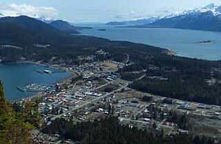
Haines is a census-designated place located in Haines Borough, Alaska, United States. It is in the northern part of the Alaska Panhandle, near Glacier Bay National Park and Preserve.

Skagway, Alaska Borough in Alaska, United States

The Municipality and Borough of Skagway is a first-class borough in Alaska on the Alaska Panhandle. As of the 2010 census, the population was 968. Estimates put the 2015 population at 1,057 people. The population doubles in the summer tourist season in order to deal with more than 900,000 visitors. Incorporated as a borough on June 25, 2007, it was previously a city in the Skagway-Yakutat-Angoon Census Area.

Diorite Intermediate intrusive igneous rock composed principally of plagioclase feldspar

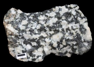
Diorite is an intrusive igneous rock composed principally of the silicate minerals plagioclase feldspar, biotite, hornblende, and/or pyroxene. The chemical composition of diorite is intermediate, between that of mafic gabbro and felsic granite. Diorite is usually grey to dark-grey in colour, but it can also be black or bluish-grey, and frequently has a greenish cast. It is distinguished from gabbro on the basis of the composition of the plagioclase species; the plagioclase in diorite is richer in sodium and poorer in calcium. Diorite may contain small amounts of quartz, microcline, and olivine. Zircon, apatite, titanite, magnetite, ilmenite, and sulfides occur as accessory minerals. Minor amounts of muscovite may also be present. Varieties deficient in hornblende and other dark minerals are called leucodiorite. When olivine and more iron-rich augite are present, the rock grades into ferrodiorite, which is transitional to gabbro. The presence of significant quartz makes the rock type quartz-diorite or tonalite, and if orthoclase is present at greater than 10 percent, the rock type grades into monzodiorite or granodiorite. A dioritic rock containing feldspathoid mineral/s and no quartz is termed foid-bearing diorite or foid diorite according to content.

Glacier Bay National Park and Preserve national park of the United States

Glacier Bay National Park and Preserve is an American national park located in Southeast Alaska west of Juneau. President Calvin Coolidge proclaimed the area around Glacier Bay a national monument under the Antiquities Act on February 25, 1925. Subsequent to an expansion of the monument by President Jimmy Carter in 1978, the Alaska National Interest Lands Conservation Act (ANILCA) enlarged the national monument by 523,000 acres on December 2, 1980, and created Glacier Bay National Park and Preserve. The national preserve encompasses 58,406 acres of public land to the immediate northwest of the park, protecting a portion of the Alsek River with its fish and wildlife habitats, while allowing sport hunting.

Lynn Canal bay

Lynn Canal is an inlet into the mainland of southeast Alaska.

Chilkoot River river in the United States of America

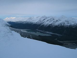
The Chilkoot River is a river in Southeast Alaska, United States, that extends about 20 miles (32 km) from its source and covers a watershed area of 100 square miles (260 km2). The source of the river is in the Takshanuk Mountains to the west and the Freebee glacier and unnamed mountains to the east. From its source, the upper reach of the river extends approximately 16 miles (26 km) to the point where it enters Chilkoot Lake. From the downstream end of the lake, the lower reach of the river flows for about 1.5 miles (2.4 km) until it enters the Chilkoot Inlet, a branch at the northern end of the Lynn Canal.

Dalton Trail

The Dalton Trail is a trail that runs between Pyramid Harbor, west of Haines, Alaska in the United States, and Fort Selkirk, in the Yukon Territory of Canada, using the Chilkat Pass. It is 396 km (246 mi) long.

The Takhinsha Mountains are a mountain range in Haines Borough and the Hoonah-Angoon Census Area in the U.S. state of Alaska, in the southeastern part of the state. They extend 40 km (25 mi) west-northwest from the northern end of the Chilkat Range to the head of Riggs Glacier, 46 km (29 mi) southwest of Skagway.

Hatcher Pass mountain pass

Hatcher Pass, also known as Hatcher's Pass, is a mountain pass through the southwest part of the Talkeetna Mountains, Alaska. It is named after Robert Hatcher, a prospector and miner. The nearest cities are Palmer and Wasilla approximately 12 miles (19 km) to the south, and Willow approximately 26 mi (42 km) to the west. The communities are at an elevation of approximately 250 ft (76 m) in the Mat-Su valley.

Taiya River river in the United States of America

The Taiya River is a 17-mile-long (27 km) river in the U.S. state of Alaska running from the border with British Columbia, Canada, to the Taiya Inlet of upper Lynn Canal.

Carrizo Mountains

The Carrizo Mountains is a small, mostly circular mountain range 15 to 20 km in diameter located on the Colorado Plateau in northeastern Arizona. The range is about 20 km (12 mi) southwest of the Four Corners. The highest summit, Pastora Peak, is 2,869 m (9,413 ft) in elevation, whereas elevations on the surrounding plateau are near 1,800 m (5,900 ft).

Gold mining in Alaska Alaska Mining District

Gold mining in Alaska, a state of the United States, has been a major industry and impetus for exploration and settlement since a few years after the United States acquired the territory from Russia. Russian explorers discovered placer gold in the Kenai River in 1848, but no gold was produced. Gold mining started in 1870 from placers southeast of Juneau, Alaska.

Willow Creek mining district Alaska Mining District

The Willow Creek mining district, also known as the Independence Mine/Hatcher Pass district, is a gold-mining area in the U.S. state of Alaska. Underground hard-rock mining of gold from quartz veins accounts for most of the mineral wealth extracted from the Hatcher Pass area. The first mining efforts were placer mining of stream gravels, and placer mining in the area has continued sporadically to this day. Robert Hatcher discovered gold and staked the first claim in the Willow Creek valley in September 1906. The first lode mill in the area started operating in 1908. Underground mining continued at a variety of locations around the pass until 1951. In the 1980s one of the area's hard-rock mines was briefly re-opened. At least one mining company is actively exploring for gold in the area now. Through 2006 the district produced 667-thousand ounces of hard rock gold and 60-thousand ounces of placer gold.

Parağaçay Municipality in Nakhchivan, Azerbaijan

Parağaçay is an urban-type settlement and the least populous municipality in the Ordubad Rayon of Nakhchivan, Azerbaijan. It is located in the west of the Ordubad-Tivi highway, 52 km in the north-east from the district center, on the right bank of the Gilanchay River, at the slope of the Zangezur ridge. Its population is busy with gardening, vegetable-growing and animal husbandry. It has a population of 102.

Atacama Fault

The Atacama Fault Zone (AFZ) is an extensive system of faults cutting across the Chilean Coastal Cordillera in Northern Chile between the Andean Mountain range and the Pacific Ocean. The fault system is North-South striking and runs for more than 1100 km North and up to 50 km in width through the Andean forearc region. The zone is a direct result of the ongoing subduction of the Eastward moving Nazca Plate beneath the South American Plate and is believed to have formed in the Early Jurassic during the beginnings of the Andean orogeny. The zone can be split into 3 regions: the North, Central and South.

Sheep Creek (Juneau, Alaska)

Sheep Creek is located 4 miles (6.4 km) southeast of Juneau, in the U.S. state of Alaska. The Juneau community of Thane was originally called Sheep Creek. Draining an area of about 5 square miles (13 km2), it empties into Gastineau Channel. The valley formed by the river has a flat, gravel, trekking trail of 3.5 miles (5.6 km), south of Mount Roberts. The Snettisham hydroelectric dam substation is situated on a trail spur. Sheep Creek Hatchery is located at the outflow.

Juneau gold belt

The Juneau gold belt is located in the southeastern portion of the U.S. state of Alaska. This belt is approximately 100 miles (160 km) in length, north/northwest-trending, and extends from Berners Bay southeastward to Windham Bay, 60 miles (97 km) southeast of Juneau, and includes Douglas Island. The belt contains over 200 gold-quartz-vein deposits with production nearing 7,000,000 ounces (200,000,000 g) of gold. More than three-quarters of Alaska's lode gold was mined from the Juneau gold belt.

Ear Mountain mountain in Alaska

Ear Mountain is an isolated mountain located on the Seward Peninsula in the U.S. state of Alaska. The mountain, with an elevation of 2,329 feet (710 m), has a belt of Cretaceous tin "granites." Though the mountain is located in an area long known for its tin deposits, it was only in 1953 and 1954 during a survey by the US Bureau of Mines that tin deposits were confirmed to be on Ear Mountain.

Bluestone River (Alaska) waterway located on the Seward Peninsula in Alaska, U.S.

Bluestone River is a waterway located on the Seward Peninsula in the U.S. state of Alaska. A tributary of the Tuksuk Channel from the south, Bluestone is a north-flowing stream situated 11 miles (18 km) southeast of Teller. It was named in 1900 by Edward Chester Barnard, topographer of the United States Geological Survey.

References

  1. 1 2 Skagway (B-2), Alaska, 15 minute Quadrangle, USGS 1954
  2. 1 2 "Feature Detail Report for: Tukgahgo Mountain". U.S. Geological Survey. Retrieved 11 February 2013.
  3. 1 2 "Tukgahgo Mountain Summit- Alaska Mountain Peak Information". Mountainzone.com. Retrieved 11 February 2013.
  4. William Bright (2004). Native American Placenames of the United States. University of Oklahoma Press. pp. 517–. ISBN   978-0-8061-3598-4 . Retrieved 7 February 2013.
  5. Geological Survey Professional Paper. U.S. Government Printing Office. 1967. pp. 859, 989, 1017–. Retrieved 14 February 2013.
  6. 1 2 3 "Unnamed Occurrences (ARDF - SK025; near Tukgahgo Mountain), Skagway District, Juneau District, Haines Borough, Alaska, USA". mindat.org. Retrieved 12 February 2013.
  7. 1 2 "Geology and Geochemistry of the Skagway B-2 Quadrangle, Southeastern Alaska" (pdf). Division of Geological and Geophysical Surveys State of Alaska. pp. 17–18. Retrieved 12 February 2013.

Coordinates: 59°18′01″N135°37′46″W / 59.30028°N 135.62944°W / 59.30028; -135.62944

Geographic coordinate system Coordinate system

A geographic coordinate system is a coordinate system that enables every location on Earth to be specified by a set of numbers, letters or symbols. The coordinates are often chosen such that one of the numbers represents a vertical position and two or three of the numbers represent a horizontal position; alternatively, a geographic position may be expressed in a combined three-dimensional Cartesian vector. A common choice of coordinates is latitude, longitude and elevation. To specify a location on a plane requires a map projection.