Millard County is a county in the U.S. state of Utah. As of the 2010 United States Census, the population was 12,503. Its county seat is Fillmore, and the largest city is Delta.

The Great Basin is the largest area of contiguous endorheic watersheds, those with no outlets, in North America. It spans nearly all of Nevada, much of Utah, and portions of California, Idaho, Oregon, Wyoming, and Baja California. It is noted for both its arid climate and the basin and range topography that varies from the North American low point at Badwater Basin in Death Valley to the highest point of the contiguous United States, less than 100 miles (160 km) away at the summit of Mount Whitney. The region spans several physiographic divisions, biomes, ecoregions, and deserts.

The Sevier River is a 400-mile (640 km)-long river in the Great Basin of southwestern Utah in the United States. Originating west of Bryce Canyon National Park, the river flows north through a chain of high farming valleys and steep canyons along the west side of the Sevier Plateau before turning southwest and terminating in the endorheic basin of Sevier Lake in the Sevier Desert. It is used extensively for irrigation along its course, with the consequence that Sevier Lake is usually dry.

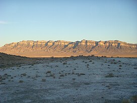
Notch Peak is a distinctive summit located on Sawtooth Mountain in the House Range, west of Delta, Utah, United States. The peak and the surrounding area are part of the Notch Peak Wilderness Study Area (WSA). Bristlecone pines, estimated to be 3,000 to 4,000 years old, are located on the ridges surrounding Notch Peak.

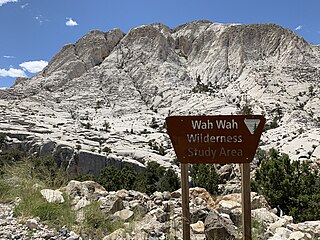
The Wah Wah Mountains are a north-south trending range in west-central Utah, part of the larger Basin and Range Province. It is bounded by Pine Valley to the west, Wah Wah Valley to the east, the Escalante Desert to the south, and on trend with the Confusion Range to the north. The Wah Wah Mountains are located in Beaver and Millard counties. State Route 21 bisects the range, crossing over Wah Wah Summit at about 6,500 feet (1,980 m) above sea level. Elevations range from about 6,000 feet (1,800 m) at the mountain front to 9,393 feet (2,863 m) in the southern Wah Wahs.
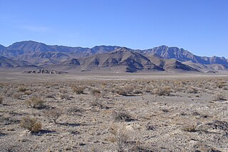
The Delamar Mountains are a mountain range in Lincoln County, Nevada, named after Captain Joseph Raphael De Lamar. The range extends for approximately 50 miles (80 km) in a NNE–SSW orientation with a width of about 11 miles (18 km). Surrounding ranges include the Burnt Springs Range and the Chief Range to the north, the Clover Mountains and Meadow Valley Mountains to the east and the Sheep Range and South Pahroc Range on the west. The Delamar Valley lies to the west, the Kane Springs Valley to the east and the Coyote Springs Valley lies to the south of the range.
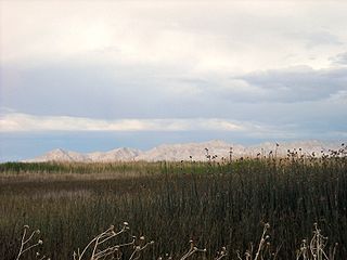
Fish Springs National Wildlife Refuge is at the southern end of the Great Salt Lake Desert, part of the Great Basin in Juab County, Utah, United States. The Refuge is managed by the United States Fish and Wildlife Service. As an oasis in the Great Basin Desert in western Utah, Fish Springs serves a variety of species including fish, migratory birds, deer, coyotes, pronghorn, cougars and other native species. The reserve can be reached by paved road from Lynndyl to Topaz Mountain and then by improved dirt road to the Pony Express Road/Lincoln Highway improved dirt road which runs through the Refuge. The Refuge also is a recreational area for permitted outdoor activities. The Fish Springs Range runs north to south and is immediately west of the Wildlife Refuge.

The House Range is a north-south trending mountain range in Millard County, of west-central Utah. The House Range was named in 1859 by James H. Simpson. It was named by Simpson because "...of its well-defined stratification and the resemblance of portions of its outline to domes, minarets, houses, and other structures."
The Confusion Range is a north-south trending mountain range in west-central Utah, United States. It is bounded by Snake Valley to the west, Tule Valley to the east, the Great Salt Lake Desert to the north, and the Ferguson Desert to the south. The range trends into the Burbank Hills, Mountain Home Range, and the Wah Wah Mountains to the south. In the central part of the range, an offshoot of the mountains to the west is known as the Conger Range. The Confusion Range is named for its "rugged isolation and confusing topography."

The Mountain Home Range is a north-south trending mountain range in western Beaver County in southwest Utah, United States. It is part of the Basin and Range Province. It is bound by Hamlin Valley to the west, Snake Valley to the north, Pine Valley to the east, and trends into the Indian Peak Range to the south. Collectively, the Mountain Home Range and Indian Peak Range are known as the Needle Mountains due to their jagged nature.

The Burbank Hills are a small northwest-southeast mountain range in western Utah, United States that lie entirely within the Hamlin-Snake Watershed, between the Snake Range and the Ferguson Desert. It is bounded by Snake Valley to the north, west, and south; and trends into the Tunnel Springs Mountains, to the southeast, opposite the Antelope Valley on its southeast border. It was named after the settlement of Burbank, Utah, and Margie Burbank Clay, the wife of local Judge E. W. Clay in the 1870s.
Wah Wah Valley is an endorheic valley within the Basin and Range of west-central Utah, United States.
Tule is a plant of the sedge family.

The Sevier Desert is a large arid section of central-west Utah, United States, and is located in the southeast of the Great Basin. It is bordered by deserts north, west, and south; its east border is along the mountain range and valley sequences at the perimeter of the Great Basin, with the large north–south Wasatch Range and its associated mountainous landforms. Its eastern border is specifically, the East Tintic, Gilson, and Canyon Mountains; also the massive Pahvant Range.

The San Francisco Mountains are a 20-mile-long (32 km) mountain range located in north‑central Beaver County, Utah, United States that extend into central-south Millard County.

The Toroweap Fault of northwest Arizona and southwest Utah is part of a fault system of the west Grand Canyon region, Arizona, US; also the west perimeter regions of the Coconino and Colorado Plateaus. The Hurricane Fault originates at the Toroweap Fault, in the region of the Colorado River, and strikes as the westerly depression of the Toroweap Fault. The Toroweap strikes northerly from the Colorado at the east of Toroweap Valley, and enters south Utah; from the Colorado River, the Hurricane Fault strikes north-northwest along the west flank of the small, regional Uinkaret Mountains, the west border of Toroweap Valley. The Hurricane Fault, and the Hurricane Cliffs strike into southwest Utah as part of the west, and southwest perimeter of the Colorado Plateau. The Hurricane Cliffs are made of Kaibab Limestone, an erosion resistant, cliff-forming rock unit.
The Crystal Peak Dolomite is a geologic formation in the Wah Wah Mountains of western Utah. It preserves fossils dating to the Middle Ordovician period.