Tumbarumba Shire

Last updated

Tumbarumba Shire
New South Wales
Tumbarumba LGA NSW.png
Location in New South Wales
Coordinates 35°45′S148°00′E / 35.750°S 148.000°E / -35.750; 148.000 Coordinates: 35°45′S148°00′E / 35.750°S 148.000°E / -35.750; 148.000
Population3,521 (2013 est) [1]
 • Density0.80150/km2 (2.0759/sq mi)
Abolished12 May 2016 (2016-05-12)
Area4,393 km2 (1,696.1 sq mi) [2]
Mayor Cr. Ian Chaffey (Independent) [3]
Council seat Tumbarumba
Region Riverina
State electorate(s) Albury
Federal division(s) Division of Riverina
Website Tumbarumba Shire
LGAs around Tumbarumba Shire:
Wagga Wagga Tumut Cooma-Monaro
Greater Hume Tumbarumba Shire Snowy River
Towong (Vic) Towong (Vic) Snowy River

Tumbarumba Shire was a local government area in the eastern Riverina region, located in the foothills of the Snowy Mountains, on the upper reaches of the Murray River in New South Wales, Australia. It came into existence in 1906. Prior to this the area covered by the shire was unincorporated. It included the town of Tumbarumba and the small towns of Rosewood, Tooma, Khancoban and Jingellic.

Contents

A 2015 review of local government boundaries recommended that the Tumbarumba Shire merge with the Tumut Shire to form a new council. This recommendation was not supported by any of the preceding IPART and Tcorp assessments, which recommended a merger between Tumut and Gundagai shires instead. When the NSW Government released their proposal in December 2015, the Government's website stated that the proposal was 'broadly consistent with Tumut Council's stated preference'.[ citation needed ] Tumut Council submitted its preferences during a consultation period following the IPART's 'Fit for the Future' report, in October 2015 after it was found 'Not Fit'. Tumbarumba Shire Council did not elect any merger partners as part of this process, with the finding it was 'Fit' as a 'Rural Council'.[ citation needed ]

As a result, many residents of Tumbarumba Shire viewed[ opinion ] Tumut Shire Council's choice to nominate a merger of the Gundagai, Tumbarumba, and Tumut shires as the catalyst behind the NSW Government proposal to merge the Tumbarumba Shire with Tumut Shire, (which was never one of Tumut Shire Council's stated preference).[ opinion ] The resulting opposition by the residents of Tumbarumba Shire was almost[ opinion ] unanimous, with a publicly convened 'Save Tumbarumba Shire' committee executing an active grass roots, public campaign.[ citation needed ]

The NSW Government proposal would see a combined Shire with an area of 8,960 square kilometres (3,460 sq mi) and support a population of approximately 14,953. [4] On 12 May 2016, the NSW Government dissolved Tumbarumba Shire and along with Tumut Shire and merged the councils to form the Snowy Valleys Council. [5]

The last mayor of Tumbarumba Shire was Cr. Ian Chaffey, an independent politician. [3]

Council

Current composition and election method

At the time of dissolution, Tumbarumba Shire Council was composed of eight councillors elected proportionally as a single ward. All councillors were elected for a fixed four-year term of office. The mayor was elected by the councillors at the first meeting of the council. The last election was held on 8 September 2012 and the makeup of the council was as follows: [6]

PartyCouncillors
  Independents and Unaligned8
Total8

The final Council, elected in 2012, in order of election, was: [6]

CouncillorPartyNotes
 Julie GiddingsUnaligned
 Ian Chaffey Independent Mayor [3]
 Rodney ShawUnaligned
 Tony a'BeckettUnaligned
 Alan BeckeIndependent
 Brent LivermoreIndependentDeputy Mayor [3] from Sept 2014 [7]
 Sue FletcherUnaligned
 George MartinUnaligned

Related Research Articles

<span class="mw-page-title-main">The Hills Shire</span> Local government area in New South Wales, Australia

The Hills Shire is a local government area in the Greater Sydney region of Sydney, New South Wales, Australia. The suburb is north-west of the Sydney central business district, and encompasses 401 square kilometres (155 sq mi) stretching from the M2 Hills Motorway in the south to Wiseman's Ferry on the Hawkesbury River in the north. The Hills Shire had a population of 157,243 as at the 2016 census.

<span class="mw-page-title-main">Murrumbidgee Shire</span> Former local government area in New South Wales, Australia

Murrumbidgee Shire was a local government area in the Riverina region of south western New South Wales, Australia. The Shire was located adjacent to the Murrumbidgee River and the Newell Highway.

<span class="mw-page-title-main">Cooma-Monaro Shire</span> Former local government area in New South Wales, Australia

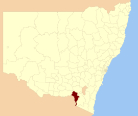
Cooma-Monaro Shire was a local government area located in the Monaro region of southern New South Wales, Australia. The area was named after the former Cooma Municipality and the former Monaro Shire, that were amalgamated to create it. The Municipality of Cooma was established in 1879, and the Monaro Shire was one of several shires established in 1906. The Monaro Shire and Cooma Municipal Council amalgamated in 1981. On 11 February 2004, Cooma-Monaro Shire absorbed a small part of the former Yarrowlumla Shire, near Michelago.

<span class="mw-page-title-main">Snowy River Shire</span> Former local government area in New South Wales, Australia

The Snowy River Shire was a local government area in the Australian Alps region of New South Wales, Australia from 1939 until May 2016. It was named after the Snowy River that runs through it. Prior to 1936, it had been named as Dalgety Shire since establishment in 1906.

<span class="mw-page-title-main">Murray Shire</span> Former local government area in New South Wales, Australia

Murray Shire was a local government area in the Riverina region of south western New South Wales, Australia. It included the towns of Moama and Mathoura. It was abolished on 12 May 2016 and its area merged with the Wakool Shire to establish the Murray River Council.

<span class="mw-page-title-main">Wakool Shire</span> Former local government area in New South Wales, Australia

Wakool Shire was a local government area in the Riverina region of New South Wales, Australia. The Shire was located between the Murray River and the Murrumbidgee River and adjacent to the Sturt Highway. Towns in the Shire are Barham, Moulamein, Tooleybuc, Wakool and Koraleigh.

<span class="mw-page-title-main">Gundagai Shire</span> Former local government area in New South Wales, Australia

Gundagai Shire was a local government area in the Riverina region of New South Wales, Australia. On 12 May 2016, Gundagai Shire was abolished and merged with the neighbouring Cootamundra Shire to establish Cootamundra-Gundagai Regional Council.

<span class="mw-page-title-main">Bombala Shire</span> Local government area in New South Wales, Australia

The Bombala Shire was a local government area in the Monaro region of south-eastern New South Wales, Australia. The Shire includes the town of Bombala, the villages of Delegate, Cathcart, Bibbenluke and the localities of Ando, Bungarby, Craigie, Mila, Rockton and Creewah. Bombala Shire was formed on 1 October 1977 by the amalgamation of the Municipality of Bombala and Bibbenluke Shire.

<span class="mw-page-title-main">Dungog Shire</span> Local government area in New South Wales, Australia

Dungog Shire is a local government area in the Hunter region of New South Wales, Australia. The Shire is situated adjacent to the Barrington Tops and consists predominantly of very rugged to hilly country which becomes less rugged from north to south.

<span class="mw-page-title-main">Boorowa Shire</span> Former local government area in New South Wales, Australia

Boorowa Council was a local government area in the South West Slopes region of New South Wales, Australia. The LGA was located adjacent to the Lachlan Valley Way and included Boorowa and the small towns of Rye Park, Rugby, Frogmore and Reids Flat. Burrowa LGA was formed on 1 September 1944 through the amalgamation of Murrungal Shire and the Municipality of Burrowa.

<span class="mw-page-title-main">Young Shire</span> Former local government area in New South Wales, Australia

Young Shire was a local government area in the South West Slopes region of New South Wales, Australia. The Shire was located adjacent to the Olympic Highway.

<span class="mw-page-title-main">Harden Shire</span> Former local government area in New South Wales, Australia

Harden Shire was a local government area in the South West Slopes region of New South Wales, Australia. The Shire included the twin towns of Harden and Murrumburrah and the small towns of Galong, Jugiong, Wombat and Kingsvale.

<span class="mw-page-title-main">Cootamundra Shire</span> Former local government area in New South Wales, Australia

Cootamundra Shire was a local government area in the Riverina region of New South Wales, Australia. The Shire was located adjacent to the Olympic Highway, the Burley Griffin Way and the Main South railway line. The Shire included the town of Cootamundra and the small towns of Stockinbingal, Brawlin and Wallendbeen and the locality of Frampton. The Shire was created on 1 April 1975 by the amalgamation of Jindalee Shire and the Municipality of Cootamundra.

<span class="mw-page-title-main">Tumut Shire</span> Former local government area in New South Wales, Australia

Tumut Shire was a local government area in the South West Slopes region of New South Wales, Australia.

<span class="mw-page-title-main">Lockhart Shire</span> Local government area in New South Wales, Australia

Lockhart Shire is a local government area in the Riverina region of New South Wales, Australia. The Shire was created in 1906 and is an agricultural and pastoral area.

<span class="mw-page-title-main">Urana Shire</span> Former local government area in New South Wales, Australia

Urana Shire was a local government area in the Riverina region of New South Wales, Australia. The Newell Highway crosses its north-west corner. The Shire included the town of Urana and the small towns of Boree Creek, Morundah, Oaklands and Rand.

<span class="mw-page-title-main">Local government in New South Wales</span>

The local government areas (LGA) of New South Wales are the third tier of government in the Australian state. Under the Local Government Act 1993 (NSW) they can manage their own affairs to the extent permitted by the legislation. They may be designated as cities or otherwise as areas, though the latter units may choose to use titles that had distinctions under older forms of the act. The smallest local government by area in the state is the Municipality of Hunter's Hill 5.7 km2 (2.2 sq mi) and the largest by area is Central Darling Shire Council 53,492 km2 (20,653 sq mi). There are 129 local government areas in the state as of December 2022.

<span class="mw-page-title-main">Federation Council, New South Wales</span> Local government area in New South Wales, Australia

The Federation Council is a local government area located in the Riverina region of New South Wales, Australia. This area was formed in 2016 from the merger of the Corowa Shire with its neighbouring Urana Shire.

<span class="mw-page-title-main">Snowy Valleys Council</span> Local government area in New South Wales, Australia

The Snowy Valleys Council is a local government area located in the South West Slopes region of New South Wales, Australia. This area was formed in 2016 from the merger of the Tumut Shire with the neighbouring Tumbarumba Shire.

<span class="mw-page-title-main">Cootamundra–Gundagai Regional Council</span> Local government area in New South Wales, Australia

Cootamundra–Gundagai Regional Council (CGRC) is a local government area located in the South West Slopes and Riverina regions of New South Wales, Australia. The council was formed on 12 May 2016 through a merger of the Cootamundra and Gundagai shires. Originally named Gundagai Council, the name was changed to Cootamundra–Gundagai Regional Council on 7 September 2016.

References

  1. "3218.0 Regional Population Growth, Australia. Table 1. Estimated Resident Population, Local Government Areas, New South Wales". 3 April 2014. Retrieved 11 September 2014.
  2. "Tumbarumba Shire Council". Department of Local Government . Retrieved 8 November 2006.
  3. 1 2 3 4 "Council and Councillors". Council. Tumbarumba Shire Council. September 2012. Retrieved 30 September 2012.
  4. "Merger proposal: Tumbarumba Shire Council, Tumut Shire Council" (PDF). Government of New South Wales. January 2016. p. 7. Retrieved 10 March 2016.
  5. "Snowy Valley Council". Stronger Councils. Government of New South Wales. 12 May 2016. Retrieved 13 May 2016.
  6. 1 2 "Tumbarumba Shire Council: Summary of First Preference and Group Votes for each Candidate". Local Government Elections 2012. Electoral Commission of New South Wales. 13 September 2012. Retrieved 29 September 2012.
  7. "Deputy Mayor Councillor Brent Livermore". Tumbarumba Shire Council. Retrieved 4 November 2015.