Monaro Highway is a 285-kilometre-long (177 mi) highway in Victoria, New South Wales, and the Australian Capital Territory, in Australia, linking Cann River in Victoria to Canberra in the Australian Capital Territory (ACT) via the Monaro region. From its southern terminus, it follows the nearby Cann River upstream towards the New South Wales border through heavily forested terrain. Within New South Wales (NSW), it makes its way through further forest before reaching the pastures typical of the Monaro. There are multiple towns and villages along the highway, including Bombala, Nimmitabel, and Cooma. The terrain within the Monaro is largely hilly, and there are numerous crossings. The road also parallels the former Bombala railway line in several locations. Within the ACT, the road becomes a high volume roadway and serves the southern suburbs of Canberra. The highway has more recently had a grade-separated dual carriageway extension constructed within Canberra, as part of the Eastern Parkway construction project. It is designated part of route M23, and route A23 within Canberra, and route B23 within Victoria and New South Wales, with a concurrency where it also carries route B72 between the two sections of Snowy Mountains Highway.

Snowy Mountains Highway is a 333-kilometre-long (207 mi) state highway located in New South Wales, Australia. Its two sections connect the New South Wales South Coast to the Monaro region, and the Monaro to the South West Slopes via the Snowy Mountains. The higher altitude regions of this road are subject to snow over the winter months, and the road also provides access to many parts of the Snowy Mountains Scheme. The highway bears the B72 shield along its entire length.

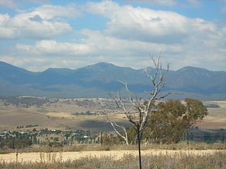
Monaro, once frequently spelt "Manaro", or in early years of settlement "Maneroo" is a region in the south of New South Wales, Australia. A small area of Victoria near Snowy River National Park is geographically part of the Monaro. While the Australian Capital Territory is not considered part of the region, some towns in the Monaro have close links with Canberra.
Michelago is a village in the Monaro region of New South Wales, Australia. The village is in the Snowy Monaro Regional Council local government area, 54 kilometres (34 mi) south of Canberra on the Monaro Highway. It was founded in the 1820s, on the main route from Sydney to the Snowy Mountains. Its name is also applied to the surrounding area, for postal and statistical purposes. At the 2016 census, Michelago had a population of 562.

Monaro, also known as Maneroo (1856–1858), Monara (1858–1879) and Manaro (1894–1904) is an electoral district of the Legislative Assembly in the Australian state of New South Wales. It is currently represented by Steve Whan of the Labor party since the 2023 New South Wales state election.

The Palerang Council was a local government area located in the Southern Tablelands region of New South Wales, Australia. On 12 May 2016 the Minister for Local Government announced dissolution of the Palerang Council with immediate effect. Together with Queanbeyan City the combined council areas were merged to establish the Queanbeyan-Palerang Regional Council. Both councils had opposed the amalgamation. Elections for the new Council area were held in September 2017. The former mayor of Queanbeyan City Council was appointed by the New South Wales Government as administrator until that date.

The Snowy River Shire was a local government area in the Australian Alps region of New South Wales, Australia from 1939 until May 2016. It was named after the Snowy River that runs through it. Prior to 1936, it had been named as Dalgety Shire since establishment in 1906.

Gundagai Shire was a local government area in the Riverina region of New South Wales, Australia. On 12 May 2016, Gundagai Shire was abolished and merged with the neighbouring Cootamundra Shire to establish Cootamundra-Gundagai Regional Council.

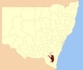
The Bombala Shire was a local government area in the Monaro region of south-eastern New South Wales, Australia. The Shire includes the town of Bombala, the villages of Delegate, Cathcart, Bibbenluke and the localities of Ando, Bungarby, Craigie, Mila, Rockton and Creewah. Bombala Shire was formed on 1 October 1977 by the amalgamation of the Municipality of Bombala and Bibbenluke Shire.

Boorowa Council was a local government area in the South West Slopes region of New South Wales, Australia. The LGA was located adjacent to the Lachlan Valley Way and included Boorowa and the small towns of Rye Park, Rugby, Frogmore and Reids Flat. Burrowa LGA was formed on 1 September 1944 through the amalgamation of Murrungal Shire and the Municipality of Burrowa.

Young Shire was a local government area in the South West Slopes region of New South Wales, Australia. The Shire was located adjacent to the Olympic Highway.

Harden Shire was a local government area in the South West Slopes region of New South Wales, Australia. The Shire included the twin towns of Harden and Murrumburrah and the small towns of Galong, Jugiong, Wombat and Kingsvale.

Cootamundra Shire was a local government area in the Riverina region of New South Wales, Australia. The Shire was located adjacent to the Olympic Highway, the Burley Griffin Way and the Main South railway line. The Shire included the town of Cootamundra and the small towns of Stockinbingal, Brawlin and Wallendbeen and the locality of Frampton. The Shire was created on 1 April 1975 by the amalgamation of Jindalee Shire and the Municipality of Cootamundra.

Tumbarumba Shire was a local government area in the eastern Riverina region, located in the foothills of the Snowy Mountains, on the upper reaches of the Murray River in New South Wales, Australia. It came into existence in 1906. Prior to this the area covered by the shire was unincorporated. It included the town of Tumbarumba and the small towns of Rosewood, Tooma, Khancoban and Jingellic.

The Bombala railway line is a branch railway line in the south of New South Wales, Australia. The northern part of it forms part of the main line from Sydney to Canberra, but the southern part is closed. It branches off the Main South line at Joppa Junction, south of Goulburn. The line is used by NSW TrainLink Xplorer services running between Sydney Central and Canberra station.

Bibbenluke is a village in the Snowy Monaro Regional Council in southern New South Wales, Australia. The village is located at a crossing point of the Monaro Highway and Bombala River. The name is derived from a local Aboriginal word either meaning "Big Lookout" or "Place of Birds".

The Snowy Monaro Regional Council is a local government area located in the Snowy Mountains and Monaro regions of New South Wales, Australia. The council was formed on 12 May 2016 through a forced merger of the Bombala, Cooma-Monaro and Snowy River shires.

Colinton is a locality in the Snowy Monaro Region, New South Wales, Australia. At the 2016 census, it had a population of 127. There was once a village and railway station of the same name.

The Ingalara Creek railway bridge is a heritage-listed former railway bridge that carried the Bombala railway line across Ingalara Creek at Michelago in the Snowy Monaro Regional Council local government area of New South Wales, Australia. It was designed by John Whitton in his capacity as Engineer-in-Chief for Railways and built in 1889. It is also known as the Michelago Rail Bridge over Ingalara Creek and the Ingalara Creek Railway Viaduct. The property is owned by Transport Asset Holding Entity, an agency of the Government of New South Wales. It was added to the New South Wales State Heritage Register on 2 April 1999. On 1 December 2020, changes were made to exemptions relating to the bridge's heritage status.
The Original Group 19 Rugby League was a competition which ran from the 1950 until 1970, in the Southern Tablelands region of New South Wales. Many clubs left for other competitions after this time, including Group 16 and Group 8. The Group 19 tag was then transferred to Canberra and later Northern New South Wales.