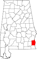
Tumbleton, Alabama

Last updated
Tumbleton, Alabama
USA Alabama location map.svg
Red pog.svg
Tumbleton
Usa edcp location map.svg
Red pog.svg
Tumbleton
Coordinates: 31°24′24″N85°15′24″W / 31.40667°N 85.25667°W / 31.40667; -85.25667 Coordinates: 31°24′24″N85°15′24″W / 31.40667°N 85.25667°W / 31.40667; -85.25667
Country United States
State Alabama
County Henry
Elevation
361 ft (110 m)
Time zone UTC-6 (Central (CST))
  Summer (DST) UTC-5 (CDT)
Area code 334
GNIS feature ID128120 [1]

Tumbleton is an unincorporated community in Henry County, Alabama, United States.

History

The origin of the name Tumbleton came from a lot of tumbling that went on in the large sand-bed under a huge post oak tree by traveling salesmen, drunks, school children, and from Tumble Bugs rolling horse manure. The very first name was Shelley's Sluice, due to all of the sand gathered at the crossroads by rain water drainage; next it was called Shelley's Crossroads, due to the Shelley families who owned the land, next it was being called Shelley Town. The first merchant, Will Taylor,a Shelley in-law, began calling the place Tumble Town due to all of the tumbling activities; later urbanizing the name to Tumbleton. The place once had 1,000 people in the Tumbleton Jr. High School District in the late 1920s. In 2019, Tumbleton is primarily a residential community with a polling place, the Shelley's Garage, which turned 100 years old in 2020, a peanut buying and shelling business, and a demolition business. Tumbleton is situated in some of the best peanut, cotton, and grain farming areas in Henry County, Alabama. [2] The settlement was founded in the 1890s, at the crossing of two dirt roads. It was formerly home to several stores, a cotton gin, grist mill, saw mill, and school. [3]

The Tumbleton soil series is named after the community. [4]

Related Research Articles

<span class="mw-page-title-main">George Washington Carver</span> American botanist and inventor (1864–1943)

George Washington Carver was an American agricultural scientist and inventor who promoted alternative crops to cotton and methods to prevent soil depletion. He was one of the most prominent black scientists of the early 20th century.

<span class="mw-page-title-main">Barbour County, Alabama</span> County in Alabama, United States

Barbour County is a county in the southeastern part of the U.S. state of Alabama. As of the 2020 census, the population was 25,223. Its county seat is Clayton. Its largest city is Eufaula. Its name is in honor of James Barbour, who served as Governor of Virginia.

<span class="mw-page-title-main">Madison County, Alabama</span> County in Alabama, United States

Madison County is located in the north central portion of the U.S. state of Alabama. As of the 2020 Census, the population was 388,153, making it the third-most populous county in Alabama. Its county seat is Huntsville. Since the mid-20th century it has become an area of defense and space research and industry.

<span class="mw-page-title-main">Marengo County, Alabama</span> County in Alabama, United States

Marengo County is a county located in the west central portion of the U.S. state of Alabama. As of the 2020 census, the population was 19,323. The largest city is Demopolis, and the county seat is Linden. It is named in honor of the Battle of Marengo near Turin, Italy, where French leader Napoleon Bonaparte defeated the Austrians on June 14, 1800.

<span class="mw-page-title-main">Union County, South Carolina</span> County in South Carolina, United States

Union County is a county located in the U.S. state of South Carolina. As of the 2020 census, the population was 27,244. Its county seat is Union. The county was created in 1785.

<span class="mw-page-title-main">Scotland County, North Carolina</span> County in North Carolina, United States

Scotland County is a county located in the southern part of the U.S. state of North Carolina and is its smallest county by area. Its county seat is and largest city is Laurinburg. The county was formed in 1899 from part of Richmond County and named in honor of the Scottish settlers who occupied the area in the 1700s. As of the 2020 census, its population was 34,174.

<span class="mw-page-title-main">Rockingham County, North Carolina</span> County in North Carolina, United States

Rockingham County is a county located in the U.S. state of North Carolina. As of the 2020 census, the population was 91,096. Its county seat is Wentworth. The county is known as "North Carolina's North Star."

<span class="mw-page-title-main">Franklin County, North Carolina</span> County in North Carolina, United States

Franklin County is a county located in the U.S. state of North Carolina. As of the 2020 census, the population was 68,573. Its county seat is Louisburg.

<span class="mw-page-title-main">Monroe County, Mississippi</span> County in Mississippi, United States

Monroe County is a county on the northeast border of the U.S. state of Mississippi next to Alabama. As of the 2020 census, the population was 34,180. Its county seat is Aberdeen.

<span class="mw-page-title-main">Tift County, Georgia</span> County in Georgia, United States

Tift County is a county located in the south central portion of the U.S. state of Georgia. As of the 2020 census, the population was 41,344. The county seat is Tifton.

<span class="mw-page-title-main">Dothan, Alabama</span> City in and county seat of Houston County, Alabama

Dothan is a city in Dale, Henry, and Houston counties and the Houston county seat in the U.S. state of Alabama. It is Alabama's eighth-largest city, with a population of 71,072 at the 2020 census. It is near the state's southeastern corner, about 20 miles (32 km) west of Georgia and 16 miles (26 km) north of Florida. It is named after the biblical city where Joseph's brothers threw him into a cistern and sold him into slavery in Egypt.

<span class="mw-page-title-main">Crossville, Alabama</span> Town in Alabama, United States

Crossville is a town in DeKalb County, Alabama, United States. At the 2010 census the population was 1,862, up from 1,431 in 2000. Crossville is located atop Sand Mountain, a southern extension of the Cumberland Plateau.

<span class="mw-page-title-main">Roff, Oklahoma</span> Town in Oklahoma, United States

Roff is a town in Pontotoc County, Oklahoma, United States. The population was 725 at the 2010 census.

<span class="mw-page-title-main">B. B. Comer</span> Democratic U.S. Senator from Alabama; Governor of Alabama

Braxton Bragg Comer was an American politician who served as the 33rd Governor of Alabama from 1907 to 1911, and a United States Senator in 1920. As governor, he achieved railroad reform, lowering rates for businesses in Alabama to make them more competitive with other states. He increased funding for the public school system, resulting in more rural schools and high schools in each county for white students, and eventually a rise in the state's literacy rate.

Hermanville is a census-designated place and unincorporated community in Claiborne County, in southwest Mississippi, United States. Its ZIP code is 39086.

<span class="mw-page-title-main">Rosemark, Tennessee</span> Unincorporated community in Tennessee, United States

Rosemark is an unincorporated residential and farm community located along Tennessee State Route 14 in northeastern Shelby County, Tennessee, United States. It had a population of 2,315 people in 2010.

Half Acre is an unincorporated community in Marengo County, Alabama, United States. It has gone through a variety of name changes since the early 20th century. The community had a post office at one time, but it no longer exists. Although a thriving community in its early years, it has since dwindled into obscurity.

<span class="mw-page-title-main">Economy of Alabama</span> Overview of the economy of the US state of Alabama

The state of Alabama has invested in aerospace, education, health care, banking, and various heavy industries, including automobile manufacturing, mineral extraction, steel production and fabrication. By 2006, crop and animal production in Alabama was valued at $1.5 billion. In contrast to the primarily agricultural economy of the previous century, this was only about 1% of the state's gross domestic product. The number of private farms has declined at a steady rate since the 1960s, as land has been sold to developers, timber companies, and large farming conglomerates.

Capps, also known as Choctawhatchee, is an unincorporated community in Henry County, Alabama, United States. Capps is located on Alabama State Route 173, 7.2 miles (11.6 km) southeast of Abbeville.

Robbins Crossroads, also known as Robbins, is an unincorporated community in Jefferson County, Alabama, United States.

References

  1. "Tumbleton". Geographic Names Information System . United States Geological Survey, United States Department of the Interior.
  2. Foscue, Virginia (1989). Place Names in Alabama. Tuscaloosa: The University of Alabama Press. p. 139. ISBN   081730410X.
  3. Smith, Larry. "Tumbleton, Alabama". ALGenWeb. Archived from the original on 24 July 2015. Retrieved 14 August 2015.
  4. United States Bureau of Chemistry and Soils; United States. Bureau of Plant Industry; United States. Bureau of Plant Industry, Soils, and Agricultural Engineering (1997). Soil survey. U.S. Dept. of Agriculture. p. 59.{{cite book}}: CS1 maint: multiple names: authors list (link)