Turgi

Last updated
Turgi
Limmattal - Turgi IMG 9767.JPG
Wappen Turgi AG.svg
Location of Turgi
Turgi
Switzerland adm location map.svg
Red pog.svg
Turgi
Reliefkarte Aargau blank.png
Red pog.svg
Turgi
Coordinates: 47°30′N8°15′E / 47.500°N 8.250°E / 47.500; 8.250
Country Switzerland
Canton Aargau
District Baden
Area
[1]
  Total1.55 km2 (0.60 sq mi)
Elevation
342 m (1,122 ft)
Population
 (31 December 2018) [2]
  Total3,014
  Density1,900/km2 (5,000/sq mi)
Time zone UTC+01:00 (Central European Time)
  Summer (DST) UTC+02:00 (Central European Summer Time)
Postal code(s)
5300
SFOS number 4042
Surrounded by Baden, Gebenstorf, Obersiggenthal, Untersiggenthal
Website www.turgi.ch
SFSO statistics
Turgi Karte Gemeinde Turgi 2007.png
Turgi

Turgi is a former municipality in the district of Baden in the canton of Aargau in Switzerland, located in the Limmat Valley (German: Limmattal). It merged with Baden on 1 January 2024.

Contents

In 2002, Turgi received the Wakker Prize for the preservation of its architectural heritage.

History

In 1883 the municipality was created when it separated from Gebenstorf. [3]

Geography

Turgi Turgi.jpg
Turgi
Aerial view (1958) ETH-BIB-Turgi-LBS H1-021255.tif
Aerial view (1958)

Turgi has an area, as of 2006, of 1.5 square kilometers (0.58 sq mi). Of this area, 17.6% is used for agricultural purposes, while 35.9% is forested. Of the rest of the land, 42.5% is settled (buildings or roads) and the remainder (3.9%) is non-productive (rivers or lakes). [4]

Coat of arms

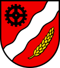
The blazon of the municipal coat of arms is Gules a Bend sinister wavy Argent between a Cog Wheel Sable in chief and Ear of Wheat Or bendwise sinister in base. [5]

Demographics

Turgi has a population (as of 31 December 2020) of 2,963. [6] As of 2008, 40.5% of the population was made up of foreign nationals. [7] Over the last 10 years the population has grown at a rate of 17%. Most of the population (as of 2000) speaks German (73.2%), with Italian being second most common ( 7.6%) and Albanian being third ( 3.2%). [4]

The age distribution, as of 2008, in Turgi is; 332 children or 11.5% of the population are between 0 and 9 years old and 298 teenagers or 10.4% are between 10 and 19. Of the adult population, 451 people or 15.7% of the population are between 20 and 29 years old. 424 people or 14.7% are between 30 and 39, 485 people or 16.8% are between 40 and 49, and 390 people or 13.5% are between 50 and 59. The senior population distribution is 238 people or 8.3% of the population are between 60 and 69 years old, 162 people or 5.6% are between 70 and 79, there are 86 people or 3.0% who are between 80 and 89,and there are 13 people or 0.5% who are 90 and older. [8]

As of 2000, there were 199 homes with 1 or 2 persons in the household, 650 homes with 3 or 4 persons in the household, and 225 homes with 5 or more persons in the household. The average number of people per household was 2.15 individuals. [9] In 2008 there were 280 single family homes (or 20.6% of the total) out of a total of 1,362 homes and apartments. [10] There were a total of 5 empty apartments for a 0.4% vacancy rate. [10] As of 2007, the construction rate of new housing units was 29.4 new units per 1000 residents. [4]

In the 2007 federal election the most popular party was the SVP which received 33% of the vote. The next three most popular parties were the SP (23.4%), the Green Party (11.5%) and the FDP (11.3%). [4]

In Turgi about 65.7% of the population (between age 25–64) have completed either non-mandatory upper secondary education or additional higher education (either university or a Fachhochschule ). [4] Of the school age population (in the 2008/2009 school year), there are 224 students attending primary school, there are 171 students attending tertiary or university level schooling in the municipality. [9]

The historical population is given in the following table: [8]

Historical population
YearPop.±%
1975 2,702    
1980 2,638−2.4%
1990 2,616−0.8%
2000 2,446−6.5%

Economy

As of  2007, Turgi had an unemployment rate of 3.37%. As of 2005, there were 7 people employed in the primary economic sector and about 2 businesses involved in this sector. 1,162 people are employed in the secondary sector and there are 20 businesses in this sector. 485 people are employed in the tertiary sector, with 85 businesses in this sector. [4]

As of 2000 there were 1,307 total workers who lived in the municipality. Of these, 1,091 or about 83.5% of the residents worked outside Turgi while 1,560 people commuted into the municipality for work. There were a total of 1,776 jobs (of at least 6 hours per week) in the municipality. [11] Of the working population, 35.5% used public transportation to get to work, and 37.8% used a private car. [4]

Transportation

Turgi railway station is a stop of the S-Bahn Zürich on the line S12.

Religion

Swiss Reformed Church of Turgi Turgi Ref Kirchturm.jpg
Swiss Reformed Church of Turgi

From the 2000 census, 1,043 or 43.5% are Roman Catholic, while 585 or 24.4% belonged to the Swiss Reformed Church. Of the rest of the population, there are 3 individuals (or about 0.13% of the population) who belong to the Christian Catholic faith. [9]

Related Research Articles

<span class="mw-page-title-main">Wettingen</span> Municipality in Aargau, Switzerland

Wettingen is a residential community in the district of Baden in the Swiss canton of Aargau. With a population about 20,000, Wettingen is the second-largest municipality in the canton.

<span class="mw-page-title-main">Zufikon</span> Municipality in Aargau, Switzerland

Zufikon is a municipality in the district of Bremgarten in the canton of Aargau in Switzerland.

<span class="mw-page-title-main">Bottenwil</span> Municipality in Aargau, Switzerland

Bottenwil is a municipality in the district of Zofingen in the canton of Aargau in Switzerland.

<span class="mw-page-title-main">Kölliken</span> Municipality in Aargau, Switzerland

Kölliken is a municipality in the district of Zofingen in the canton of Aargau in Switzerland. It is also home to one of the two most toxic hazardous waste landfills in all of Switzerland. The other site is in Bonfol, Canton Jura.

<span class="mw-page-title-main">Reitnau</span> Municipality in Aargau, Switzerland

Reitnau is a municipality in the district of Zofingen in the canton of Aargau in Switzerland. On 1 January 2019 the former municipality of Attelwil merged into the municipality of Reitnau.

<span class="mw-page-title-main">Mühlau</span> Municipality in Aargau, Switzerland

Mühlau is a municipality in the district of Muri in the canton of Aargau in Switzerland.

<span class="mw-page-title-main">Gebenstorf</span> Municipality in Aargau, Switzerland

Gebenstorf is a municipality in the district of Baden in the canton of Aargau in Switzerland.

<span class="mw-page-title-main">Obersiggenthal</span> Municipality in Aargau, Switzerland

Obersiggenthal is a municipality located in the Limmat Valley, within the district of Baden, in the canton of Aargau, Switzerland.

<span class="mw-page-title-main">Stetten, Aargau</span> Municipality in Aargau, Switzerland

Stetten is a municipality in the district of Baden in the canton of Aargau in Switzerland.

<span class="mw-page-title-main">Hirschthal</span> Municipality in Aargau, Switzerland

Hirschthal is a municipality in the district of Aarau of the canton of Aargau in Switzerland.

<span class="mw-page-title-main">Böbikon</span> Former municipality in Aargau, Switzerland

Böbikon is a village and former municipality in the district of Zurzach in Canton Aargau in Switzerland. It is located just 2 km south of the border with Germany.

<span class="mw-page-title-main">Riniken</span> Municipality in Aargau, Switzerland

Riniken is a municipality in the district of Brugg in the canton of Aargau in Switzerland.

<span class="mw-page-title-main">Holziken</span> Municipality in Aargau, Switzerland

Holziken is a municipality in the district of Kulm in the canton of Aargau in Switzerland.

<span class="mw-page-title-main">Zetzwil</span> Municipality in Aargau, Switzerland

Zetzwil is a municipality in the district of Kulm in the canton of Aargau in Switzerland.

<span class="mw-page-title-main">Wittnau, Aargau</span> Municipality in Aargau, Switzerland

Wittnau is a municipality in the district of Laufenburg in the canton of Aargau in Switzerland.

Sisseln is a municipality in the district of Laufenburg in the canton of Aargau in Switzerland.

<span class="mw-page-title-main">Zeihen</span> Municipality in Aargau, Switzerland

Zeihen is a municipality in the district of Laufenburg in the canton of Aargau in Switzerland.

<span class="mw-page-title-main">Schupfart</span> Municipality in Aargau, Switzerland

Schupfart is a municipality in the district of Rheinfelden in the canton of Aargau in Switzerland.

Obermumpf is a municipality in the district of Rheinfelden in the canton of Aargau in Switzerland.

<span class="mw-page-title-main">Wislikofen</span> Former municipality in Aargau, Switzerland

Wislikofen is a village and former municipality in the district of Zurzach in the canton of Aargau in Switzerland. On 1 January 2022 the former municipalities of Bad Zurzach, Baldingen, Böbikon, Kaiserstuhl, Rekingen, Rietheim, Rümikon and Wislikofen merged into the new municipality of Zurzach.

References

  1. "Arealstatistik Standard - Gemeinden nach 4 Hauptbereichen". Federal Statistical Office. Retrieved 13 January 2019.
  2. "Ständige Wohnbevölkerung nach Staatsangehörigkeitskategorie Geschlecht und Gemeinde; Provisorische Jahresergebnisse; 2018". Federal Statistical Office. 9 April 2019. Retrieved 11 April 2019.
  3. Amtliches Gemeindeverzeichnis der Schweiz published by the Swiss Federal Statistical Office (in German) accessed 14 January 2010
  4. 1 2 3 4 5 6 7 Swiss Federal Statistical Office accessed 12-February-2010
  5. Flags of the World.com accessed 12-February-2010
  6. "Ständige und nichtständige Wohnbevölkerung nach institutionellen Gliederungen, Geburtsort und Staatsangehörigkeit". bfs.admin.ch (in German). Swiss Federal Statistical Office - STAT-TAB. 31 December 2020. Retrieved 21 September 2021.
  7. Statistical Department of Canton Aargau -Bereich 01 -Bevölkerung (in German) accessed 20 January 2010
  8. 1 2 Statistical Department of Canton Aargau -Bevölkerungsdaten für den Kanton Aargau und die Gemeinden (Archiv) (in German) accessed 20 January 2010
  9. 1 2 3 Statistical Department of Canton Aargau - Aargauer Zahlen 2009 (in German) accessed 20 January 2010
  10. 1 2 Statistical Department of Canton Aargau (in German) accessed 20 January 2010
  11. Statistical Department of Canton Aargau-Bereich 11 Verkehr und Nachrichtenwesen (in German) accessed 21 January 2010