Obersiggenthal

Last updated

Obersiggenthal
Nussbaumen (AG) IMG 9782 ShiftN.jpg
Wappen Obersiggenthal AG.svg
Location of Obersiggenthal
Obersiggenthal
Switzerland adm location map.svg
Red pog.svg
Obersiggenthal
Reliefkarte Aargau blank.png
Red pog.svg
Obersiggenthal
Coordinates: 47°29′N8°18′E / 47.483°N 8.300°E / 47.483; 8.300
Country Switzerland
Canton Aargau
District Baden
Area
[1]
  Total8.36 km2 (3.23 sq mi)
Elevation
420 m (1,380 ft)
Highest elevation
(Ebne)
618 m (2,028 ft)
Lowest elevation
(Limmat at Schiffmühle)
340 m (1,120 ft)
Population
 (31 December 2018) [2]
  Total8,565
  Density1,000/km2 (2,700/sq mi)
Time zone UTC+01:00 (Central European Time)
  Summer (DST) UTC+02:00 (Central European Summer Time)
Postal code(s)
5415
SFOS number 4038
Localities Nussbaumen, Kirchdorf, Rieden; Hertenstein, Tromsberg
Surrounded by Baden, Endingen, Ennetbaden, Freienwil, Lengnau, Turgi, Untersiggenthal, Würenlingen
Website www.obersiggenthal.ch
SFSO statistics

Obersiggenthal is a municipality located in the Limmat Valley, within the district of Baden, in the canton of Aargau, Switzerland.

Contents

History

Obersiggenthal is first mentioned around 1303-08 as Sikental. [3]

Geography

Former Oederlin AG Factory dock in Obersiggenthal-Rieden Obersiggenthal Oederlin.jpg
Former Oederlin AG Factory dock in Obersiggenthal-Rieden
Aerial view (1964) ETH-BIB-Obersiggenthal-LBS H1-024471.tif
Aerial view (1964)

Obersiggenthal has an area, as of 2006, of 8.4 km2 (3.2 sq mi). Of this area, 35.6% is used for agricultural purposes, while 43.5% is forested. Of the rest of the land, 19.6% is settled (buildings or roads) and the remainder (1.3%) is non-productive (rivers or lakes). [4]

The municipality is located in the Baden district, between the Siggenberg and the Limmat river. It consists of the villages of Nussbaumen, Kirchdorf and Rieden and the hamlets of Tromsberg, Ebnet and Hertenstein.
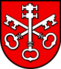
Coat of arms

The blazon of the municipal coat of arms is Gules two Keys Argent in saltire crossed by the third double warded in Pale. [5]

Demographics

Obersiggenthal has a population (as of 31 December 2020) of 8,661. [6] As of 2008, 32.1% of the population was made up of foreign nationals. [7] Over the last 10 years the population has grown at a rate of 6.8%. Most of the population (as of 2000) speaks German (80.7%), with Serbo-Croatian being second most common ( 4.8%) and Italian being third ( 2.6%). [4]

The age distribution, as of 2008, in Obersiggenthal is; 782 children or 9.6% of the population are between 0 and 9 years old and 883 teenagers or 10.8% are between 10 and 19. Of the adult population, 944 people or 11.5% of the population are between 20 and 29 years old. 1,182 people or 14.5% are between 30 and 39, 1,349 people or 16.5% are between 40 and 49, and 1,010 people or 12.4% are between 50 and 59. The senior population distribution is 977 people or 12.0% of the population are between 60 and 69 years old, 660 people or 8.1% are between 70 and 79, there are 337 people or 4.1% who are between 80 and 89, and there are 50 people or 0.6% who are 90 and older. [8]

As of 2000, there were 508 homes with 1 or 2 persons in the household, 1,733 homes with 3 or 4 persons in the household, and 976 homes with 5 or more persons in the household. The average number of people per household was 2.26 individuals. [9] In 2008 there were 960 single family homes (or 25.4% of the total) out of a total of 3,783 homes and apartments. [10]

In the 2007 federal election the most popular party was the SVP which received 29.6% of the vote. The next three most popular parties were the SP (19.3%), the CVP (18.9%) and the FDP (15.1%). [4]

In Obersiggenthal about 76.5% of the population (between age 25-64) have completed either non-mandatory upper secondary education or additional higher education (either university or a Fachhochschule ). [4] Of the school age population (in the 2008/2009 school year), there are 529 students attending primary school, there are 213 students attending secondary school, there are 174 students attending tertiary or university level schooling in the municipality. [9]

The historical population is given in the following table: [3]

Historical population
YearPop.±%
1780 631    
1803 755+19.7%
1850 1,183+56.7%
1900 1,504+27.1%
1950 2,856+89.9%
2000 7,561+164.7%

Heritage sites of national significance

The tithe barn at Kirchweg 14 is listed as a Swiss heritage site of national significance. [11]

Economy

As of  2007, Obersiggenthal had an unemployment rate of 2.36%. As of 2005, there were 77 people employed in the primary economic sector and about 24 businesses involved in this sector. 360 people are employed in the secondary sector and there are 58 businesses in this sector. 1,098 people are employed in the tertiary sector, with 187 businesses in this sector. [4]

As of 2000 there were 3,850 total workers who lived in the municipality. Of these, 3,150 or about 81.8% of the residents worked outside Obersiggenthal while 712 people commuted into the municipality for work. There were a total of 1,412 jobs (of at least 6 hours per week) in the municipality. [12]

Religion

From the 2000 census, 3,540 or 46.8% are Roman Catholic, while 1,927 or 25.5% belonged to the Swiss Reformed Church. Of the rest of the population, there are 8 individuals (or about 0.11% of the population) who belong to the Christian Catholic faith. [9]

Related Research Articles

<span class="mw-page-title-main">Birmenstorf, Aargau</span> Municipality in Aargau, Switzerland

Birmenstorf is a municipality in the district of Baden in the canton of Aargau in Switzerland.

<span class="mw-page-title-main">Freienwil</span> Municipality in Aargau, Switzerland

Freienwil is a municipality in the district of Baden in the canton of Aargau in Switzerland.

Staffelbach is a municipality in the district of Zofingen in the canton of Aargau in Switzerland.

<span class="mw-page-title-main">Wettingen</span> Municipality in Aargau, Switzerland

Wettingen is a residential community in the district of Baden in the Swiss canton of Aargau. With a population about 20,000, Wettingen is the second-largest municipality in the canton.

<span class="mw-page-title-main">Würenlos</span> Municipality in Aargau, Switzerland

Würenlos is a municipality in the district of Baden in the canton of Aargau in Switzerland. It lies north of the river Limmat, next to the canton of Zürich, located in the Limmat Valley.

<span class="mw-page-title-main">Rudolfstetten-Friedlisberg</span> Municipality in Aargau, Switzerland

Rudolfstetten-Friedlisberg is a municipality in the district of Bremgarten in the canton of Aargau in Switzerland. Prior to 1953, the municipality was officially known simply as Rudolfstetten.

<span class="mw-page-title-main">Reitnau</span> Municipality in Aargau, Switzerland

Reitnau is a municipality in the district of Zofingen in the canton of Aargau in Switzerland. On 1 January 2019 the former municipality of Attelwil merged into the municipality of Reitnau.

Strengelbach is a municipality in the district of Zofingen in the canton of Aargau in Switzerland.

<span class="mw-page-title-main">Waltenschwil</span> Municipality in Aargau, Switzerland

Waltenschwil is a municipality in the district of Muri in the canton of Aargau in Switzerland.

<span class="mw-page-title-main">Bergdietikon</span> Municipality in Aargau, Switzerland

Bergdietikon is a municipality in the district of Baden in the canton of Aargau in Switzerland. It is located in the Limmat Valley.

<span class="mw-page-title-main">Neuenhof, Aargau</span> Municipality in Aargau, Switzerland

Neuenhof is a municipality in the district of Baden in the canton of Aargau in Switzerland, located in the Limmat Valley.

<span class="mw-page-title-main">Stetten, Aargau</span> Municipality in Aargau, Switzerland

Stetten is a municipality in the district of Baden in the canton of Aargau in Switzerland.

<span class="mw-page-title-main">Hirschthal</span> Municipality in Aargau, Switzerland

Hirschthal is a municipality in the district of Aarau of the canton of Aargau in Switzerland.

<span class="mw-page-title-main">Muhen</span> Municipality in Aargau, Switzerland

Muhen is a municipality in the district of Aarau of the canton of Aargau in Switzerland.

<span class="mw-page-title-main">Tägerig</span> Municipality in Aargau, Switzerland

Tägerig is a municipality in the district of Bremgarten in the canton of Aargau in Switzerland.

<span class="mw-page-title-main">Villnachern</span> Municipality in Aargau, Switzerland

Villnachern is a municipality in the district of Brugg in the canton of Aargau in Switzerland.

<span class="mw-page-title-main">Wittnau, Aargau</span> Municipality in Aargau, Switzerland

Wittnau is a municipality in the district of Laufenburg in the canton of Aargau in Switzerland.

<span class="mw-page-title-main">Wölflinswil</span> Municipality in Aargau, Switzerland

Wölflinswil is a municipality in the district of Laufenburg in the canton of Aargau in Switzerland.

<span class="mw-page-title-main">Zeihen</span> Municipality in Aargau, Switzerland

Zeihen is a municipality in the district of Laufenburg in the canton of Aargau in Switzerland.

<span class="mw-page-title-main">Schupfart</span> Municipality in Aargau, Switzerland

Schupfart is a municipality in the district of Rheinfelden in the canton of Aargau in Switzerland.

References

  1. "Arealstatistik Standard - Gemeinden nach 4 Hauptbereichen". Federal Statistical Office. Retrieved 13 January 2019.
  2. "Ständige Wohnbevölkerung nach Staatsangehörigkeitskategorie Geschlecht und Gemeinde; Provisorische Jahresergebnisse; 2018". Federal Statistical Office. 9 April 2019. Retrieved 11 April 2019.
  3. 1 2 Obersiggenthal in German , French and Italian in the online Historical Dictionary of Switzerland .
  4. 1 2 3 4 5 Swiss Federal Statistical Office accessed 9 February 2010
  5. Flags of the World.com accessed 9 February 2010
  6. "Ständige und nichtständige Wohnbevölkerung nach institutionellen Gliederungen, Geburtsort und Staatsangehörigkeit". bfs.admin.ch (in German). Swiss Federal Statistical Office - STAT-TAB. 31 December 2020. Retrieved 21 September 2021.
  7. Statistical Department of Canton Aargau -Bereich 01 -Bevölkerung (in German) accessed 20 January 2010
  8. Statistical Department of Canton Aargau -Bevölkerungsdaten für den Kanton Aargau und die Gemeinden (Archiv) (in German) accessed 20 January 2010
  9. 1 2 3 Statistical Department of Canton Aargau - Aargauer Zahlen 2009 (in German) accessed 20 January 2010
  10. Statistical Department of Canton Aargau (in German) accessed 20 January 2010
  11. Swiss inventory of cultural property of national and regional significance Archived 1 May 2009 at the Wayback Machine 21.11.2008 version, (in German) accessed 9 February 2010
  12. Statistical Department of Canton Aargau-Bereich 11 Verkehr und Nachrichtenwesen (in German) accessed 21 January 2010