Freienwil

Last updated

Freienwil
Freienwil 5651.jpg
CHE Freienwil Flag.svg
Wappen Freienwil.svg
Location of Freienwil
Freienwil
Switzerland adm location map.svg
Red pog.svg
Freienwil
Reliefkarte Aargau blank.png
Red pog.svg
Freienwil
Coordinates: 47°30′N8°20′E / 47.500°N 8.333°E / 47.500; 8.333
Country Switzerland
Canton Aargau
District Baden
Area
[1]
  Total3.99 km2 (1.54 sq mi)
Elevation
465 m (1,526 ft)
Population
 (31 December 2018) [2]
  Total1,053
  Density260/km2 (680/sq mi)
Time zone UTC+01:00 (Central European Time)
  Summer (DST) UTC+02:00 (Central European Summer Time)
Postal code(s)
5423
SFOS number 4028
Surrounded by Lengnau, Obersiggenthal, Unterehrendingen, Oberehrendingen, Ennetbaden
Website freienwil.ch
SFSO statistics

Freienwil is a municipality in the district of Baden in the canton of Aargau in Switzerland.

Contents

History

Freienwil is first mentioned around 1227–1234 as Friginwillare. [3]

Geography

Freienwil has an area, as of 2006, of 4 km2 (1.5 sq mi). Of this area, 52.6% is used for agricultural purposes, while 38.5% is forested. The rest of the land (8.9%) is settled. [4]

The village lies in the eastern edge of the Siggenbergs in a valley between the Limmat and the Surb valleys. The Rickenbach is the main stream.
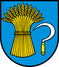
Coat of arms

The blazon of the municipal coat of arms is Azure a Garb Or in base sinister a Sickle Argent handled of the second. [5]

Demographics

Population growth Population Growth 1400-2006.jpg
Population growth

The historical population is given in the following table: [3] [6]

Historical population
YearPop.±%
1799 280    
1850 506+80.7%
1900 370−26.9%
1950 416+12.4%
1975 495+19.0%
1980 508+2.6%
1990 647+27.4%
2000 753+16.4%

Freienwil has a population (as of 31 December 2020) of 1,110. [7] As of 2008, 11.1% of the population was made up of foreign nationals. [8] Over the last 10 years the population has grown at a rate of 22.4%. Most of the population (as of 2000) speaks German (94.2%), with French being second most common (1.7%) and English being third (1.5%). [4]

The age distribution, as of 2008, in Freienwil is; 109 children or 12.4% of the population are between 0 and 9 years old and 112 teenagers or 12.7% are between 10 and 19. Of the adult population, 83 people or 9.4% of the population are between 20 and 29 years old. 92 people or 10.4% are between 30 and 39, 185 people or 21.0% are between 40 and 49, and 144 people or 16.3% are between 50 and 59. The senior population distribution is 91 people or 10.3% of the population are between 60 and 69 years old, 43 people or 4.9% are between 70 and 79, there are 21 people or 2.4% who are between 80 and 89,and there is 1 person who is between 90 and older. [6]

As of 2000, there were 21 homes with 1 or 2 persons in the household, 112 homes with 3 or 4 persons in the household, and 145 homes with 5 or more persons in the household. The average number of people per household was 2.62 individuals. [9] In 2008 there were 192 single family homes (or 55.3% of the total) out of a total of 347 homes and apartments. [10]

In the 2007 federal election the most popular party was the SVP which received 29.8% of the vote. The next three most popular parties were the SP (20.7%), the CVP (18.2%) and the Green Party (13.2%). [4]

In Freienwil about 85.5% of the population (between age 25 and 64) have completed either non-mandatory upper secondary education or additional higher education (either university or a Fachhochschule ). [4] Of the school age population (in the 2008/2009 school year), there are 96 students attending primary school in the municipality. [9] The municipality has a kindergarten and a primary school.

Transportation

Freienwil lies on the little-used Kantonsstrasse between Ennetbaden and Lengnau. The village is served by the once-an-hour postbus (every 30 minutes at peak) operating on the Baden–Endingen–Tegerfelden route.

Economy

The local economy is limited to a number of jobs in agriculture, in trade and within the service range. Most employed persons are commuters and work in Baden and Zürich.

As of  2007, Freienwil had an unemployment rate of 0.78%. As of 2005, there were 38 people employed in the primary economic sector and about 17 businesses involved in this sector. 18 people were employed in the secondary sector and there were six businesses in this sector. 51 people were employed in the tertiary sector, with 24 businesses in this sector. [4]

As of 2000 there were 396 total workers who lived in the municipality. Of these, 339 or about 85.6% of the residents worked outside Freienwil while 16 people commuted into the municipality for work. There were a total of 73 jobs (of at least six hours per week) in the municipality. [11]

Religion

From the 2000 census, 415 or 55.1% are Roman Catholic, while 206 or 27.4% belonged to the Swiss Reformed Church. [9]

Catholic chapel in Freienwil FreienwilKaussen2.JPG
Catholic chapel in Freienwil

Related Research Articles

<span class="mw-page-title-main">Bellikon</span> Municipality in Aargau, Switzerland

Bellikon is a municipality in the district of Baden in the canton of Aargau in Switzerland.

<span class="mw-page-title-main">Birmenstorf, Aargau</span> Municipality in Aargau, Switzerland

Birmenstorf is a municipality in the district of Baden in the canton of Aargau in Switzerland.

<span class="mw-page-title-main">Ennetbaden</span> Municipality in Aargau, Switzerland

Ennetbaden is a municipality in the district of Baden in the canton of Aargau in Switzerland, located in the Limmat Valley.

<span class="mw-page-title-main">Fislisbach</span> Municipality in Aargau, Switzerland

Fislisbach is a municipality in the district of Baden in the canton of Aargau in Switzerland.

<span class="mw-page-title-main">Densbüren</span> Municipality in Aargau, Switzerland

Densbüren is a municipality in the Aarau District of the canton of Aargau in Switzerland.

<span class="mw-page-title-main">Killwangen</span> Municipality in Aargau, Switzerland

Killwangen is a municipality in the district of Baden in the canton of Aargau in Switzerland.

<span class="mw-page-title-main">Bergdietikon</span> Municipality in Aargau, Switzerland

Bergdietikon is a municipality in the district of Baden in the canton of Aargau in Switzerland. It is located in the Limmat Valley.

<span class="mw-page-title-main">Ehrendingen</span> Municipality in Aargau, Switzerland

Ehrendingen is a municipality in the district of Baden in the canton of Aargau in Switzerland.

<span class="mw-page-title-main">Gebenstorf</span> Municipality in Aargau, Switzerland

Gebenstorf is a municipality in the district of Baden in the canton of Aargau in Switzerland.

<span class="mw-page-title-main">Künten</span> Municipality in Aargau, Switzerland

Künten is a municipality in the district of Baden in the canton of Aargau in Switzerland. It lies on the Reuss River and includes the previously independent community of Sulz, which merged with Künten in 1973.

<span class="mw-page-title-main">Mellingen</span> Municipality in Aargau, Switzerland

Mellingen is a historic town and a municipality in the district of Baden in the canton of Aargau in Switzerland. The town is located on the Reuss.

<span class="mw-page-title-main">Mägenwil</span> Municipality in Aargau, Switzerland

Mägenwil is a municipality in the district of Baden in the canton of Aargau in Switzerland.

<span class="mw-page-title-main">Neuenhof, Aargau</span> Municipality in Aargau, Switzerland

Neuenhof is a municipality in the district of Baden in the canton of Aargau in Switzerland, located in the Limmat Valley.

<span class="mw-page-title-main">Niederrohrdorf</span> Municipality in Aargau, Switzerland

Niederrohrdorf is a municipality in the district of Baden in the canton of Aargau in Switzerland.

<span class="mw-page-title-main">Oberrohrdorf</span> Municipality in Aargau, Switzerland

Oberrohrdorf is a municipality in the district of Baden in the canton of Aargau in Switzerland.

<span class="mw-page-title-main">Obersiggenthal</span> Municipality in Aargau, Switzerland

Obersiggenthal is a municipality located in the Limmat Valley, within the district of Baden, in the canton of Aargau, Switzerland.

<span class="mw-page-title-main">Turgi</span> Municipality in Aargau, Switzerland

Turgi is a former municipality in the district of Baden in the canton of Aargau in Switzerland, located in the Limmat Valley. It merged with Baden on 1 January 2024.

<span class="mw-page-title-main">Untersiggenthal</span> Municipality in Aargau, Switzerland

Untersiggenthal is a municipality in the district of Baden in the canton of Aargau in Switzerland, located in the Limmat Valley.

<span class="mw-page-title-main">Küttigen</span> Municipality in Aargau, Switzerland

Küttigen is a municipality in the district of Aarau of the canton of Aargau in Switzerland.

<span class="mw-page-title-main">Eggenwil</span> Municipality in Aargau, Switzerland

Eggenwil is a municipality in the district of Bremgarten in the canton of Aargau in Switzerland.

References

  1. "Arealstatistik Standard - Gemeinden nach 4 Hauptbereichen". Federal Statistical Office. Retrieved 13 January 2019.
  2. "Ständige Wohnbevölkerung nach Staatsangehörigkeitskategorie Geschlecht und Gemeinde; Provisorische Jahresergebnisse; 2018". Federal Statistical Office. 9 April 2019. Retrieved 11 April 2019.
  3. 1 2 Freienwil in German , French and Italian in the online Historical Dictionary of Switzerland .
  4. 1 2 3 4 5 Swiss Federal Statistical Office Archived 5 January 2016 at the Wayback Machine accessed 8 February 2010
  5. Flags of the World.com accessed 8 February 2010
  6. 1 2 Statistical Department of Canton Aargau -Bevölkerungsdaten für den Kanton Aargau und die Gemeinden (Archiv) Archived 22 February 2012 at the Wayback Machine (in German) accessed 20 January 2010
  7. "Ständige und nichtständige Wohnbevölkerung nach institutionellen Gliederungen, Geburtsort und Staatsangehörigkeit". bfs.admin.ch (in German). Swiss Federal Statistical Office - STAT-TAB. 31 December 2020. Retrieved 21 September 2021.
  8. Statistical Department of Canton Aargau -Bereich 01 -Bevölkerung Archived 22 February 2012 at the Wayback Machine (in German) accessed 20 January 2010
  9. 1 2 3 Statistical Department of Canton Aargau – Aargauer Zahlen 2009 Archived 22 February 2012 at the Wayback Machine (in German) accessed 20 January 2010
  10. Statistical Department of Canton Aargau Archived 22 February 2012 at the Wayback Machine (in German) accessed 20 January 2010
  11. Statistical Department of Canton Aargau-Bereich 11 Verkehr und Nachrichtenwesen Archived 22 February 2012 at the Wayback Machine (in German) accessed 21 January 2010