Possession Island is a small island in the Torres Strait Islands group off the coast of far northern Queensland, Australia. It is inhabited by a group of Torres Strait Islanders, the Kaurareg, though the Ankamuti were also indigenous to the island.

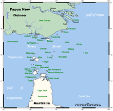
The Torres Strait, also known as Zenadh Kes, is a strait between Australia and the Melanesian island of New Guinea. It is 150 km (93 mi) wide at its narrowest extent. To the south is Cape York Peninsula, the northernmost extremity of the Australian mainland. To the north is the Western Province of Papua New Guinea. It is named after the Spanish navigator Luís Vaz de Torres, who sailed through the strait in 1606.

Cape York Peninsula is a peninsula located in Far North Queensland, Australia. It is the largest wilderness in northern Australia. The land is mostly flat and about half of the area is used for grazing cattle. The relatively undisturbed eucalyptus-wooded savannahs, tropical rainforests and other types of habitat are now recognised and preserved for their global environmental significance. Although much of the peninsula remains pristine, with a diverse repertoire of endemic flora and fauna, some of its wildlife may be threatened by industry and overgrazing as well as introduced species and weeds.
The Torres Strait Islands are an archipelago of at least 274 small islands in the Torres Strait, a waterway separating far northern continental Australia's Cape York Peninsula and the island of New Guinea. They span an area of 48,000 km2 (19,000 sq mi), but their total land area is 566 km2 (219 sq mi).

Thursday Island, colloquially known as TI, or in the Kawrareg dialect, Waiben or Waibene, is an island of the Torres Strait Islands, an archipelago of at least 274 small islands in the Torres Strait. TI is located approximately 39 kilometres north of Cape York Peninsula in Far North Queensland, Australia.

Central Queensland is an imprecisely-defined geographical division of Queensland that centres on the eastern coast, around the Tropic of Capricorn. Its major regional centre is Rockhampton. The region extends from the Capricorn Coast west to the Central Highlands at Emerald, north to the Mackay Regional Council southern boundary, and south to Gladstone. The region is also known as Capricornia. It is one of Australia's main coal exporting regions.
Far North Queensland (FNQ) is the northernmost part of the Australian state of Queensland. Its largest city is Cairns and it is dominated geographically by Cape York Peninsula, which stretches north to the Torres Strait, and west to the Gulf Country. The waters of Torres Strait include the only international border in the area contiguous with the Australian mainland, between Australia and Papua New Guinea.
North Queensland or the Northern Region is the northern part of the Australian state of Queensland that lies just south of Far North Queensland. Queensland is a massive state, larger than many countries, and its tropical northern part has been historically remote and undeveloped, resulting in a distinctive regional character and identity.

Saibai Island, commonly called Saibai, is an island of the Torres Strait Islands archipelago, located in the Torres Strait of Queensland, Australia. The island is situated north of the Australian mainland and south of the island of New Guinea. The island is a locality within the Torres Strait Island Region local government area. The town of Saibai is located on the north-west coast of the island.

Trochus Island is an island of the Torres Strait Islands archipelago, located in the Great Barrier Reef Marine Park, east of Cape York Peninsula, in Queensland, Australia.
Turtle Island is an island of the Torres Strait Islands archipelago, located in the Great Barrier Reef Marine Park, east of Cape York Peninsula, in Queensland, Australia.

Halfway Island is an island of the Torres Strait Islands archipelago located approximately 150 kilometres (93 mi) northeast of Thursday Island in the Cumberland Passage of Torres Strait, Queensland, Australia. Halfway Island is about 100 kilometres (62 mi) west of Yule Entrance.

Badu or Badu Island, is an island in the Torres Strait 60 kilometres (37 mi) north of Thursday Island, Queensland, Australia. Badu Island is also a locality in the Torres Strait Island Region, and Wakaid is the only town, located on the south-east coast. This island is one of the Torres Strait Islands. The language of Badu is Kala Lagaw Ya.

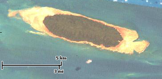
Yam Island, called Yama or Iama in the Kulkalgau Ya language or Turtle-backed Island in English, is an island of the Bourke Isles group of the Torres Strait Islands, located in the Tancred Passage of the Torres Strait in Queensland, Australia. The island is situated approximately 100 kilometres (62 mi) northeast of Thursday Island and measures about 2 square kilometres (0.77 sq mi). The island is an official locality known as Iama Island within the local government area of Torres Strait Island Region. The town, also called Yam Island, is located on the north-west coast of the island. In the 2021 census, Iama Island had a population of 275 people.
Turnagain, also called Buru Island, is an island of the Western Islands region of the Torres Strait Islands archipelago, located in the northern section of Torres Strait, Queensland, Australia. Turnagain is located within the Torres Strait Island Region Local government area.
The Bourke Isles are a group of islands and islets in the archipelago known as the Torres Strait Islands, located west of the Cumberland Passage in the Torres Strait, and are part of the state of Queensland, Australia. The isles are situated approximately 130 kilometres (81 mi) northeast of Thursday Island and 54 kilometres (34 mi) southwest of Darnley Island.

The Duncan Islands are a group of islands in the Torres Strait Islands archipelago, northwest of the Bramble Channel of Torres Strait in Queensland, Australia. The islands are situated north of Thursday Island and approximately 15 kilometres (9.3 mi) southwest of Badu Island. The Duncan Islands are located within the Torres Strait Island Region local government area.
Kaurareg is the name for one of the Indigenous Australian groups collectively known as Torres Strait Islander peoples, although many or most identify as Aboriginal Australians. They are the traditional owners of Thursday Island (Waiben) as well as a number of Torres Strait Islands.
The Jackey Jackey Creek, also often called Jacky Jacky Creek, is a creek in the Cape York Peninsula region of Far North Queensland, Australia.

South Mission Beach is a coastal town and locality in the Cassowary Coast Region, Queensland, Australia. In the 2021 census, the locality of South Mission Beach had a population of 968 people.