
Bass Strait is a strait separating the island state of Tasmania from the Australian mainland. The strait provides the most direct waterway between the Great Australian Bight and the Tasman Sea, and is also the only maritime route into the economically prominent Port Phillip Bay.
An islet is a very small, often unnamed island. Most definitions are not precise, but some suggest that an islet has little or no vegetation and cannot support human habitation. It may be made of rock, sand and/or hard coral; may be permanent or tidal ; and may exist in the sea, lakes, rivers or any other sizeable bodies of water.

The Torres Strait, also known as Zenadh Kes, is a strait between Australia and the Melanesian island of New Guinea. It is 151 km (94 mi) wide at its narrowest extent. To the south is Cape York Peninsula, the northernmost extremity of the Australian mainland. To the north is the Western Province of Papua New Guinea. It is named after the Spanish navigator Luís Vaz de Torres, who sailed through the strait in 1606.

Thursday Island, colloquially known as TI, or in the Kawrareg dialect, Waiben or Waibene, is an island of the Torres Strait Islands, an archipelago of at least 274 small islands in the Torres Strait. TI is located approximately 39 kilometres north of Cape York Peninsula in Far North Queensland, Australia. Thursday Island is also the name of the town in the south and west of the island and also the name of the locality which contains the island within the Shire of Torres. The town of Rose Hill is located on the north-eastern tip of the island.

Murray Island in the Torres Strait Island Region, Queensland, Australia. The island is part of the Murray Island Group in the Torres Strait. The town is on the island's northwest coast and within the locality of Mer Island. The island is of volcanic origin, the most easterly inhabited island of the Torres Strait Islands archipelago, just north of the Great Barrier Reef. The name Meer/Mer/Maer comes from the native Meriam language. In the 2016 census, Murray Island had a population of 453.

Hinchinbrook Island is an island in the Cassowary Coast Region, Queensland, Australia. It lies east of Cardwell and north of Lucinda, separated from the north-eastern coast of Queensland by the narrow Hinchinbrook Channel. Hinchinbrook Island is part of the Great Barrier Reef Marine Park and wholly protected within the Hinchinbrook Island National Park, except for a small and abandoned resort. It is the largest island on the Great Barrier Reef. It is also the largest island national park in Australia.
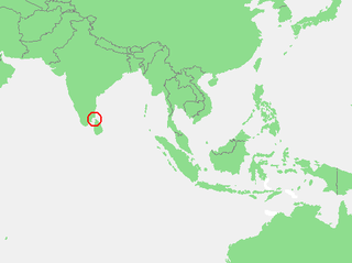
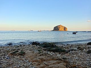
The Gulf of Mannar is a large shallow bay forming part of the Laccadive Sea in the Indian Ocean with an average depth of 5.8 m (19 ft). It lies between the southeastern tip of India and the west coast of Sri Lanka, in the Coromandel Coast region. The chain of low islands and reefs known as Ram Sethu, which includes Mannar Island, separates the Gulf of Mannar from Palk Bay, which lies to the north between India and Sri Lanka. The estuaries of Thamirabarani River and Vaippar River of South India and the Malvathu Oya of Sri Lanka drain into the Gulf. The dugong is found here.
Bootie Island is a small island in the Shire of Cook in Far North Queensland, Australia. It is part of the Cockburn Islands Group.

Turtle Head Island is an island of the Torres Strait Islands archipelago, located in the Great Barrier Reef Marine Park, east of Cape York Peninsula, in Queensland, Australia.

Albany Island or Pabaju is an island off the north-eastern coast of Cape York Peninsula in the Adolphus Channel and part of the Manar Group of islands of Queensland, Australia. It is within the locality of Somerset in the Shire of Torres.
MiddleBrother Islet is a small uninhabited island at the east entrance of the Adolphus Channel of the Torres Strait, in Queensland, Australia. It is located about 7 km south of Mount Adolphus Island, 7 km east of Albany Island, and 1.5 km west of the South Ledge Reef.

Mount Adolphus Island, also called Muri or Mori in the native language, is an island of the Torres Strait Islands archipelago that is located at the very tip of Cape York Peninsula on the northern side of the Adolphus Channel, across from Albany Island and about 40 kilometres (25 mi) northeast of Bamaga in the far north region of Queensland, Australia.

Rossel Island is the easternmost island of the Louisiade Archipelago, within the Milne Bay Province of Papua New Guinea. Tree Islet is situated 1.5 miles (2.4 km) to the north-west, while Wule Island is situated 1.5 miles (2.4 km) westward.

RMS Quetta was a Royal Mail Ship that was wrecked on the Far North Queensland coast of Australia on 28 February 1890. Quetta's sinking killed 134 of the 292 people on board, making it one of Queensland's biggest maritime catastrophes. It was caused by collision with an uncharted rock in the Adolphus Channel.
Bramble Cay, also known as Maizab Kaur and Massaramcoer, is a small cay located at the northeastern edge of Australia and the Torres Strait Islands of Queensland and at the northern end of the Great Barrier Reef. Lying around 50 km (31 mi) north of Erub Island in the Gulf of Papua, it is the northernmost point of land of Australia and marks the end of the Great Barrier Reef.
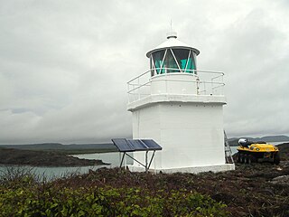
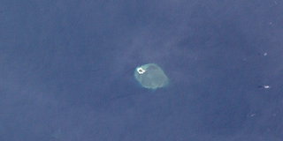
Eborac Island Light is an active lighthouse on Eborac Island, a small rocky island in the Adolphus Channel just off Cape York, the northern tip of Cape York Peninsula, Far North Queensland, Australia. It guides ships into the coastal channel inside the Great Barrier Reef. A concrete structure was built in 1921 and converted to solar power in 1990. It was replaced with a fiberglass structure in 2012.
Brother Island or Brothers Island may refer to any of several islands and island groups around the world, including

The Quetta Memorial Precinct is a heritage-listed Anglican church precinct in Douglas Street, Thursday Island, Shire of Torres, Queensland, Australia. The precinct comprises the All Souls and St Bartholomew's Cathedral Church, the Bishop's House, and the Church Hall. The precinct was built as a memorial to the 134 lives lost in the shipwreck of the RMS Quetta on 28 February 1890. The church was designed in 1892–1893 by architect John H. Buckeridge. It was added to the Queensland Heritage Register on 27 July 2001.

