Conesus Lake is located in Livingston County, New York. Conesus Lake is the westernmost of New York's eleven Finger Lakes. It is located off Interstate 390 about 15 miles (24 km) south of Interstate 90.
Cross Lake is on the border of Cayuga and Onondaga Counties in New York, United States. The lake lies within the boundaries of the traditional Onondaga Indian Nation, and is reputed in local tradition to be the boyhood home of Hiawatha, the great peace maker. However, Onondaga Lake is also said to be Hiawatha's home.

Delta Reservoir, also known as Delta Lake, is a reservoir located in Oneida County, New York, United States. It was formed by the impoundment of the Mohawk River. Most of the lake is within the southwest part of the Town of Western, north of Rome. The western part of the lake is in the Town of Lee.
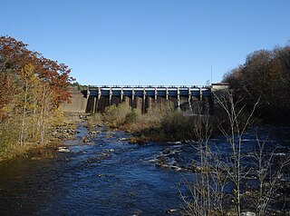
Hinckley Lake is located by Hinckley, New York. Originally dammed up to supply water to the Erie Canal, the lake provides municipal water supply to 130,000 people in the greater Utica, New York area, is a source of hydropower, and supports recreation during all seasons. The lake is located in the towns of Russia in Herkimer County, and Remsen in Oneida County. This body of water is one of many man made lakes in the Upstate NY region. Its sister lake is Delta Lake, also dammed up to supply water to the Erie Canal.
Lime Lake is a reservoir in Cattaraugus County, New York, in the United States. Lime Lake is an English translation of the Native American name Tecarnowundo.
Lake Moraine is a mesotrophic lake located 2.5 miles (4.0 km) northeast of Hamilton, New York. The lake is 261 acres (1.06 km2), consisting of two basins which are separated by a causeway and interconnected by a culvert. The northern basin is 79 acres (0.32 km2) and is relatively shallow with a maximum depth of 12 feet (3.7 m) and average depth of 3.7 feet (1.1 m). The larger southern basin is 172 acres (0.70 km2) and has a maximum depth of 45 feet (14 m) and an average depth of 17.7 feet (5.4 m). Payne Brook is the lake's outflow that flows into the Chenango River.
Norwood Lake is a man-made lake located by Norwood, New York. Fish species present in the reservoir are smallmouth bass, northern pike, rock bass, yellow perch, and walleye. There is a carry down boat launch located on Riverside Road.
Evergreen Lake is a lake located northeast of Stillwater, New York. The outflow creek flows into Stillwater Reservoir. Fish species present in the lake are brown bullhead, and brook trout. Access via trail from the north shore of Stillwater Reservoir. No motors are allowed on Evergreen Lake.
Moshier Reservoir is a reservoir located southeast of Moshier Falls, New York. Fish species present in the lake are rock bass, yellow perch, tiger muskie, white sucker, and black bullhead. There is state owned carry down trail access near the inlet.
Forestport Reservoir is a reservoir located by Forestport, New York. The reservoir was created by the impoundment of the Black River. Fish species present in the reservoir are yellow perch, lake trout, pickerel, white sucker, rock bass, smallmouth bass, and brown bullhead. There is state owned beach launch off Route 28.

Quaker Lake is located south of Coldspring, New York. Fish species present in the lake are rainbow trout, brown trout, brook trout, and black bullhead. There is a state owned carry down launch located in Allegany State Park off NY-280. The state park also offers a swimming area and facilities on the lake.
Waterport Reservoir is a reservoir located by Waterport, New York. Fish species present in the lake are brown trout, lake trout, atlantic salmon, coho salmon, chinook salmon, steelhead trout, and walleye. There is a beach launch off Waterport Road on the northeast shore.
Almond Lake also known as Almond Reservoir is a man-made lake located by Almond, New York. Fish species present in the lake include largemouth bass, yellow perch, black crappie, and pumpkinseed sunfish. There is access via boat launch in Kanakadea Recreation Area.
Jamesville Reservoir is a lake located by Jamesville, New York. Fish species present in the lake include bluegill, largemouth bass, yellow perch, black bullhead, tiger muskie, rock bass, smallmouth bass, pickerel, walleye, and pumpkinseed sunfish. There is carry down access located at the Jamesville Beach Park with the purchase of a day use fee.
Whitney Point Reservoir is a man-made lake located by Whitney Point, New York. Fish species present in the lake include largemouth bass, smallmouth bass, walleye, northern pike, tiger muskie, yellow perch, pickerel, and pumpkinseed sunfish. There is access via state owned gravel ramp boat launch off County Route 13. There is also a state owned hard surface ramp off NY-26 in Dorchester Park. Fishing and boating are prohibited within 400 feet of the inlet and outlet. Motors up to 25 horsepower are permitted. There is a 10-mile per hour speed limit. Water-skiing, overnight mooring or beaching are not permitted.
Salmon River Reservoir, also known as the Redfield Reservoir, is a man-made lake located near the hamlet of Redfield, New York. The reservoir was created with the completion of a hydroelectric dam in 1912. It has the capacity to hold 56,000 acre-feet (69,000,000 m3) of water. It is the larger of the Salmon River's two reservoirs.

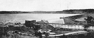
DeRuyter Reservoir is a man-made lake located north of Puckerville, New York. Fish species present in the lake include smallmouth bass, pickerel, yellow perch, rock bass, black bullhead, common sunfish, and walleye. There is access by fee on the south shore at the general store. The reservoir was constructed from 1861 to 1863 to supply water for the Erie Canal but by the following year had proved to hold insufficient water. The dam has been worked on at least twice, draining the lake by several inches each time.
Lebanon Reservoir is a man-made lake is located north of Campbell, New York. Fish species present in the lake include pumpkinseed sunfish, and rainbow trout. There is access by state owned launch off Reservoir Road, 4 miles west of the Village of Hamilton, New York.
Eaton Reservoir also called Eaton Brook Reservoir is a man-made lake located by Erieville, New York. Fish species present in the lake include pumpkinseed sunfish, walleye, smallmouth bass, yellow perch, bluegill, pickerel, rock bass, rainbow trout, and largemouth bass.
Mill Brook Reservoir is a man-made lake located by New Berlin, New York. Fish species present in the lake include pumpkinseed sunfish, and rainbow trout. There is access via boat launch off Nate Clark Lane.

