Related Research Articles

Amlwch is a port town and community in Wales. It is situated on the north coast of the Isle of Anglesey, on the A5025 which connects it to Holyhead and to Menai Bridge. As well as Amlwch town and Amlwch Port, other settlements within the community include Burwen, Bull Bay (Porthllechog) and Pentrefelin. The town has a beach in Llaneilian, and it has significant coastal cliffs. Tourism is an important element of the local economy. At one time it was a booming mining town that became the centre of a vast global trade in copper ore. The harbour inlet became a busy port and significant shipbuilding and ship repair centre, as well as an embarkation point with boats sailing to the Isle of Man and to Liverpool. The community covers an area of about 18 square kilometres.
Turton Urban District was, from 1873 to 1974, a local government district centred on the historical area of Turton in the administrative county of Lancashire, England.
Maelor was a rural district in the administrative county of Flintshire, Wales, from 1894 to 1974. The area approximated to the hundred of Maelor or English Maelor, and was notable for forming a detached part of the county, surrounded by Cheshire, Denbighshire and Shropshire. The administrative centre was located at Overton.
Wharfedale was a rural district in the West Riding of Yorkshire from 1894 to 1974. It comprised the northern side of lower Wharfedale, the lower Washburn Valley and several parishes between Leeds and the River Wharfe. Until 1937 it also included a detached part, the parish of Esholt north of Bradford.
Howden was a rural district in the East Riding of Yorkshire, England from 1894 to 1974.
Goole was a rural district in the West Riding of Yorkshire, England from 1894 to 1974.
Uwchaled was a rural district in the administrative county of Denbighshire, Wales, from 1894 to 1935. The name denoted the upper reaches of the River Aled, and originated in the medieval cwmwd (commote) of Uwch Aled. The rural district was created by the Local Government Act 1894, and comprised the part of the existing Corwen Rural Sanitary District in Denbighshire.
Westhoughton was a parliamentary constituency in Lancashire, England. Centred on the former mining and cotton town of Westhoughton, it returned one Member of Parliament (MP) to the House of Commons of the Parliament of the United Kingdom.
St Dogmells was a rural district in the administrative county of Pembrokeshire, Wales from 1894 to 1934.
Hiraethog was a rural district of the administrative county of Denbighshire, Wales, from 1935 to 1974. The district took its name from the historic district of Mynydd Hiraethog.
Holywell was a rural district in the administrative county of Flintshire, Wales, from 1894 to 1974.
Dwyran was a rural district in the administrative county of Anglesey, Wales from 1894 to 1933.
Valley was a rural district part of the administrative county of Anglesey, Wales from 1894 to 1974.

The Municipal Borough of Farnworth was a local government district centred on the town of Farnworth in the administrative county of Lancashire, England. A local board of health had been established for Farnworth in 1863, which was reconstituted as an urban district in 1899, before being granted a charter of incorporation to become a municipal borough in 1939. Following abolition of the local authority in 1974, Farnworth became an unparished area of the Metropolitan Borough of Bolton in Greater Manchester.
Pocklington was a rural district in the East Riding of Yorkshire, England from 1894 to 1974.
Runcorn Urban District was an urban district centred around the town of Runcorn in Cheshire, England from 1894 until 1974.
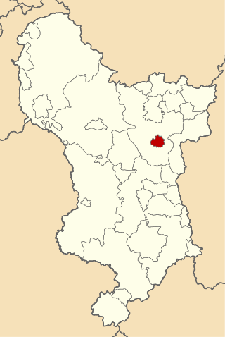
Clay Cross was an Urban District in Derbyshire, England from 1894 to 1974. It was created under the Local Government Act 1894.
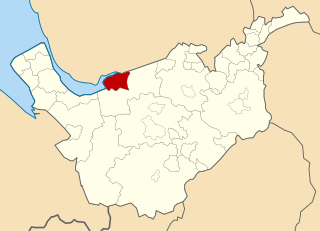
Kearsley was, from 1865 to 1974, a local government district centred on the town of Kearsley in the administrative county of Lancashire, England.
Chorley Rural District was a rural district in the administrative county of Lancashire, England from 1894 to 1974.

Loddon and Clavering Rural District was a rural district in Norfolk, England from 1894 to 1935., continuing, with very slight boundary changes, as Loddon Rural District until 1974.
References
- ↑ Annual Report of the Local Government Board. 1902. p. 295. Retrieved 18 January 2024.