Tyldesley Loopline

Last updated

Contents

Tyldesley Loopline
BSicon numN090.svg
BSicon CONTg.svg
BSicon UWu2.svg
BSicon CONT4+2.svg
BSicon HST3.svg
Newton-le-Willows
BSicon STR+1.svg
BSicon STR2+4u.svg
BSicon STRc3.svg
BSicon ABZgl+l.svg
BSicon STRc1.svg
BSicon eHSTq.svg
BSicon STR+4.svg
BSicon STR+r.svg
Lowton
Parkside
BSicon exlHST.svg
BSicon vSHI2l-.svg
BSicon CONT2+g.svg
BSicon exlvHST@F.svg
BSicon exlvHST@F-.svg
BSicon evSHI2gl-.svg
Kenyon Junction
Glazebury and
Bury Lane
BSicon exlv-HST.svg
BSicon BS2+l.svg
BSicon BS2c4.svg
BSicon exHST.svg
Pennington
BSicon STR.svg
BSicon exSTR2.svg
BSicon exABZgl.svg
BSicon exSTRc3.svg
BSicon exCONTfq.svg
Flow Moss
BSicon eHST.svg
BSicon exSTRc1.svg
BSicon exSTR.svg
BSicon exdCONT4-.svg
BSicon dSTR.svg
BSicon ucSTRq.svg
BSicon xmhKRZa.svg
BSicon ucSTRq.svg
Astley
BSicon eHST.svg
BSicon exhHSTe.svg
Leigh
BSicon STR.svg
BSicon exlCONTf1.svg
BSicon exvABZg+1-.svg
Lamb's Cottage
BSicon eHST.svg
BSicon exHST.svg
Tyldesley
BSicon STR.svg
BSicon exHST.svg
Ellenbrook
Barton Moss
BSicon eHST.svg
BSicon exABZg+l.svg
BSicon exCONTfq.svg
BSicon STR.svg
BSicon exHST.svg
Worsley
Patricroft
BSicon HST.svg
BSicon exHST.svg
Monton Green
BSicon STR2.svg
BSicon exSTRl.svg
BSicon STRc3.svg
BSicon exKRZu.svg
BSicon exCONTfq.svg
Eccles Junction
BSicon STRc1.svg
BSicon xABZg+4.svg
Eccles
BSicon HST.svg
BSicon CONTf.svg

The Tyldesley Loopline was part of the London and North Western Railway's Manchester and Wigan Railway line from Eccles to the junction west of Tyldesley station and its continuance south west via Bedford Leigh to Kenyon Junction on the Liverpool and Manchester Railway. The line opened on 1 September 1864 with stations at Worsley, Ellenbrook, Tyldesley, Leigh and Pennington before joining the Liverpool and Manchester Railway at Kenyon Junction.

Construction

The London and North Western Railway Bill received royal assent in July 1861 and the first sod was cut at Worsley by the Earl of Ellesmere in the September. [1] During construction, a Roman road was uncovered at Worsley. The railway was just over 16 miles long with 88 bridges, a sandstone cutting at Parr Brow, Tyldesley and a 22-arch viaduct which took the railway through Leigh and over the Bridgewater Canal. The work was expected to have been completed by May 1863 but lasted until the summer of 1864. [2]

Development

Stations between Tyldesley and Wigan at Chowbent, Hindley Green and Platt Bridge opened on the same day. A branch line leaving the Tyldesley to Eccles line at Roe Green Junction with stations at Walkden, Little Hulton and Plodder Lane was authorised in 1865 and opened in 1870. The line was extended to Great Moor Street in Bolton in 1874. Monton Green station [3] between Eccles station and Worsley station [4] opened in 1877 to serve new housing. In 1876 Bedford Leigh was renamed Leigh & Bedford and in 1914 was again renamed to Leigh. Chowbent was renamed Howe Bridge in 1901. [5]

Stations on the line became part of the London Midland and Scottish Railway in 1923, and the London Midland Region of British Railways on nationalisation in 1948.

Collieries

Coal, and the many collieries that were being developed in the area, was the chief motivation for building a railway in the area and the railway's supporters included many local colliery owners and industrialists. These included the Earl of Ellesmere owner of the Bridgewater Collieries, the Fletchers of Fletcher, Burrows and Company and millowner Caleb Wright. [1] Collieries linked to the railway include Astley and Tyldesley Collieries' St George's, Nook and Gin Pit Collieries which were connected at Jackson's sidings, Bedford Colliery in Leigh was connected at Speakman's sidings on the Pennington branch and the Shakerley, Yew Tree and Cleworth Hall Collieries belonging to the Tyldesley Coal Company had a connection at Green's Sidings to the east of Tyldesley station and Ramsden's Shakerley Collieries had its own sidings. [6] Mosley Common Colliery was connected at Ellenbrook and mines connected to the Bridgewater Collieries system including Sandhole Colliery joined the line between Roe Green and Worsley at Sanderson's Sidings. [7]

Closure

The Tyldesley Loopline closed following the Beeching cuts on 5 May 1969 and Leigh, Tyldesley, Monton Green and Worsley stations were closed. [8] The former trackbed which passes through the Metropolitan Borough of Wigan area was reserved in the Unitary Development Plan in case the rail route could be reinstated. A guided bus route [9] running along the former trackbed to Ellenbrook was proposed [10] but was not universally popular. [11] Salford City Council used the railway trackbed outside the Wigan boundary for recreational purposes turning it into a rail trail. [12] The Leigh-Salford-Manchester Bus Rapid Transit opened in April 2016. Its 4.5-mile guided busway section from Leigh via Tyldesley to Ellenbrook operates along the old rail alignment. Of Transport for Greater Manchester’s (TfGM) £122m overall spending on the bus route to Manchester Central Hospitals via the city centre, £68m was spent on the guided busway track and associated infrastructure. [13]

Related Research Articles

<span class="mw-page-title-main">Boothstown</span> Human settlement in England

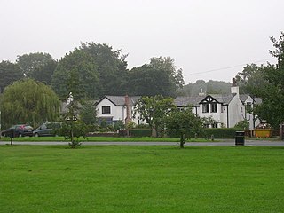
Boothstown is a suburban village in the City of Salford in Greater Manchester, England. Boothstown forms part of the Boothstown and Ellenbrook ward, which had a population at the 2011 Census of 9,599. The village is within the boundaries of the historic county of Lancashire, west of the City of Salford, bordered to the north by the East Lancashire Road A580 and to the south by the Bridgewater Canal. Historically, it was a hamlet partly in Worsley township in the parish of Eccles, and partly in Tyldesley in the parish of Leigh.

<span class="mw-page-title-main">Astley, Greater Manchester</span> Human settlement in England

Astley is a village in the Metropolitan Borough of Wigan, Greater Manchester, England. Within the boundaries of the historic county of Lancashire, it is crossed by the Bridgewater Canal and the A580 East Lancashire Road. Continuous with Tyldesley, it is equidistant from Wigan and Manchester, both 8.3 miles (13.4 km) away. Astley Mosley Common ward had a population of 11,270 at the 2011 Census.

<span class="mw-page-title-main">Tyldesley</span> Market town in Greater Manchester, England

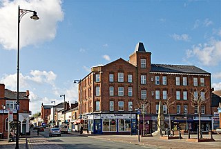
Tyldesley is a market town in Metropolitan Borough of Wigan in Greater Manchester, England. Within the boundaries of the historic county of Lancashire, it is north of Chat Moss near the foothills of the West Pennine Moors, 8 miles (12.9 km) southeast of Wigan and 9 miles (14.5 km) northwest of Manchester. At the United Kingdom Census 2001, the Tyldesley built-up area subdivision, excluding Shakerley, had a population of 16,142.

<span class="mw-page-title-main">Monton</span> Human settlement in England

Monton is a village in the City of Salford, Greater Manchester, England. It is contiguous with nearby Eccles, Salford and Swinton.

<span class="mw-page-title-main">Walkden</span> Town in City of Salford, Greater Manchester, England

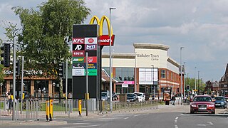
Walkden is a town in the City of Salford in Greater Manchester, England, six miles northwest of Salford, and seven miles of Manchester.

<span class="mw-page-title-main">Winton, Greater Manchester</span> Human settlement in England

Winton is an area of the City of Salford in Greater Manchester, England, which in 2014 had a population of 12,339.

The Manchester and Wigan Railway refers to a railway in North West England, opened in 1864 and closed to passengers on 3 May 1969, which was part of the London and North Western Railway before the Grouping of 1923. This route was an alternative to the surviving route through Swinton, Walkden and Atherton.

<span class="mw-page-title-main">Ellenbrook, Greater Manchester</span> Human settlement in England

Ellenbrook is a suburb of Worsley, in the City of Salford in Greater Manchester, England. Ellenbrook is 6.8 miles (10.9 km) west of Manchester, 5 miles (8.0 km) west of Salford and 4.6 miles (7.4 km) south of Bolton. Historically a part of Lancashire, it is close to Astley, Mosley Common and Walkden, by the East Lancashire Road.

<span class="mw-page-title-main">Monton Green railway station</span> Former railway station in England

Monton Green railway station is a closed station in Eccles.

<span class="mw-page-title-main">Tyldesley railway station</span> Former railway station in England

Tyldesley railway station is a closed railway station in Lancashire. It was situated within the historic county of Lancashire.

Leigh was a railway station in Bedford, Leigh, Greater Manchester, England, United Kingdom on the London and North Western Railway. Leigh was in the historic county of Lancashire. Its station opened as Bedford Leigh in 1864, was renamed Leigh & Bedford in 1876 and Leigh in 1914. The station closed in 1969.

<span class="mw-page-title-main">Roe Green</span> Human settlement in England

Roe Green is a suburban area of Worsley, in the City of Salford, Greater Manchester, England. Historically in Lancashire, it was anciently a hamlet built around what is now the village green. It is the largest of the City of Salford's conservation areas, selected because of its village green, an unusual feature in the region. Roe Green is adjacent to junction 13 of the M60 motorway.

Kenyon Junction was a railway station at Kenyon near Culcheth in Warrington, England. The station was built at the junction of the Liverpool and Manchester Railway and the Kenyon and Leigh Junction Railway. It was situated in the historic county of Lancashire. The station opened in 1830 as Bolton Junction and closed to passengers on 2 January 1961 before closing completely on 1 August 1963. The junction fell out of use when the line serving Leigh was closed in 1969.

Pennington railway station served Pennington, Leigh, Greater Manchester, England on the Bolton and Leigh Railway. It was situated within the historic county of Lancashire.

The Astley and Tyldesley Collieries Company formed in 1900 owned coal mines on the Lancashire Coalfield south of the railway in Astley and Tyldesley, then in the historic county of Lancashire, England. The company became part of Manchester Collieries in 1929 and some of its collieries were nationalised in 1947.

Tyldesley Coal Company was a coal mining company formed in 1870 in Tyldesley, on the Manchester Coalfield in the historic county of Lancashire, England that had its origins in Yew Tree Colliery, the location for a mining disaster that killed 25 men and boys in 1858.

<span class="mw-page-title-main">Bedford, Greater Manchester</span> One of three townships that merged to form Leigh, England

Bedford, a suburb of Leigh, Greater Manchester is one of three ancient townships, Bedford, Pennington and Westleigh, that merged in 1875 to form the town of Leigh. Historically, Bedford was in Lancashire.

Bedford Colliery, also known as Wood End Pit, was a coal mine on the Manchester Coalfield in Bedford, Leigh, Lancashire, England. The colliery was owned by John Speakman, who started sinking two shafts on land at Wood End Farm in the northeast part of Bedford, south of the London and North Western Railway's Tyldesley Loopline in about 1874. Speakman's father owned Priestners, Bankfield, and Broadoak collieries in Westleigh. Bedford Colliery remained in the possession of the Speakman family until it was amalgamated with Manchester Collieries in 1929.

Manchester Collieries was a coal mining company with headquarters in Walkden formed from a group of independent companies operating on the Manchester Coalfield in 1929. The Mining Industry Act of 1926 attempted to stem the post-war decline in coal mining and encourage independent companies to merge in order to modernise and better survive the economic conditions of the day. Robert Burrows of the Atherton company Fletcher Burrows proposed a merger of several independent companies operating to the west of Manchester. The merger was agreed and took place in March 1929.

<span class="mw-page-title-main">New Manchester</span>

New Manchester or The City was an isolated mining community on the Manchester Coalfield north of Mosley Common in the Tyldesley township, England. It lies west of a boundary stone at Ellenbrook which marks the ancient boundary of the Hundreds of Salford and West Derby, the boundary of Eccles and Leigh ecclesiastical parishes, Tyldesley, Worsley and Little Hulton townships and the metropolitan districts of Wigan and Salford. The route of the Roman road from Manchester to Wigan and the Tyldesley Loopline passed south of the village. The Lancashire and Yorkshire Railway's Manchester to Southport line passed to the north.

References

Citations

  1. 1 2 Sweeney 1996, p. 71.
  2. Sweeney 1996, p. 72.
  3. Monton Green Station, Subterranea Britannica, retrieved 28 February 2010
  4. Worsley Station, Subterranea Britannica, retrieved 28 February 2010
  5. Sweeney 1996, p. 70.
  6. Sweeney 1996, p. 92.
  7. Sweeney 1996, p. 149.
  8. Sweeney 1996, p. 114.
  9. Leigh Salford Manchester Busway Project (PDF), brtuk.org, archived from the original (PDF) on 20 May 2013, retrieved 28 February 2010
  10. What's happening and when (PDF), Transport for Greater Manchester, archived from the original (PDF) on 2 November 2012, retrieved 7 August 2013
  11. Gomm, Brian (19 August 2009), "Busway 'off the rails'", Leigh Journal, Newsquest Media Group, retrieved 28 February 2010
  12. Monton Trail (PDF), Visit Salford, retrieved 28 February 2010
  13. Busway begins, Bus & Coach Buyer, 5 April 2016, retrieved 27 April 2016

Bibliography

  • Sweeney, D. J. (1996), A Lancashire Triangle Part One, Triangle Publishing, ISBN   0-9529333-0-6