U.S. Route 169 in Oklahoma

Last updated

US 169.svg

U.S. Highway 169

U.S. Route 169 in Oklahoma
US 169 highlighted in red
Route information
Maintained by ODOT
Length73.67 mi [1]  (118.56 km)
Existed1930[ citation needed ]–present
Major junctions
South endUS 64.svgOklahoma State Highway 364.svgCreek Turnpike.svgOklahoma State Highway 364.svg US 64  / SH-364  / Creek Turnpike in Tulsa
Major intersectionsI-44.svgOklahoma State Highway 66.svg I-44  / SH-66 in Tulsa
I-244 (long).svgUS 412.svg I-244  / US 412 in Tulsa
US 60.svg US 60 near Nowata
North endUS 169.svg US-169 at the Kansas state line
Location
Country United States
State Oklahoma
Counties Tulsa, Rogers, Nowata
Highway system
  • Oklahoma State Highway System
Oklahoma State Highway 167.svg SH-167 Oklahoma State Highway 171.svg SH-171

U.S. Route 169 (also known as Mingo Valley Expressway and Pearl Harbor Memorial Expressway in the Tulsa Area) is a U.S. highway that begins in Tulsa southeast of Downtown. The highway runs north into Kansas.

Contents

Route description

U.S. 169 begins at an interchange with the Creek Turnpike and U.S. 64 in Tulsa. [2] US-64/US-169 then head north from the Creek Turnpike, and the two routes pass through southeast Tulsa on a due north course, as the Mingo Valley Expressway. Upon reaching the Broken Arrow Expressway (State Highway 51), US-64 splits off toward Downtown Tulsa, while US-169 continues north through east Tulsa. The next interchange US-169 has with another freeway is with I-44; 1.8 miles (2.9 km) to the north of this, it interchanges with I-244. As it continues north, US-169 serves as the western terminus of SH-266. The freeway crosses Bird Creek on new bridges built in 2015-2016 (replacing a pair of 1960-vintage through truss bridges) seven miles (11 km) north of I-44. [3] [4]

US-169 then enters the north Tulsa suburb of Owasso. Here, the freeway's interchange with 2nd Avenue also forms the eastern terminus of SH-135, an unsigned highway. [5] The freeway continues on towards Collinsville, where it has a concurrency with SH-20. North of Collinsville, the freeway ends, and US-169 continues northeast as an at-grade highway. The highway briefly crosses into Rogers County, then re-enters Tulsa County, before returning to Rogers County once again. [5] [6]

In Rogers County, US-169 heads northeast until it reaches the town of Oologah, birthplace of Will Rogers, where it serves as the western terminus for SH-88. South of the town, US-169 crosses Fourmile Creek, a tributary of the Verdigris River; the route will parallel this creek until its source as the road continues north. The highway also runs parallel to a rail line for the remainder of its time in Oklahoma, and several miles to the east, it also parallels the shoreline of Oologah Lake. As the highway passes through northern Rogers County, the highway bisects the town of Talala. [7]

Soon after US-169 crosses from Rogers County to Nowata County, the highway passes through the unincorporated location of Watova, Oklahoma. The route then enters the county seat, Nowata. US-169 Alternate follows the old route of US-169 through downtown Nowata, while mainline US-169 cuts through the eastern side of town. Both branches of US-169 intersect with US-60 in Nowata. North of Nowata, the highway passes to the west of Nowata Municipal Airport, then crosses California Creek, a tributary of the Verdigris. Southeast of Delaware, US-169 meets SH-28 at its western terminus. As US-169 continues north, it passes to the east of Delaware and Lenapah. East of Lenapah, it begins a concurrency with SH-10, which lasts for 4+12 miles (7.2 km) before SH-10 splits off to the west. US-169 continues north through unincorporated Elliott, then enters the border town of South Coffeyville. In South Coffeyville, the highway crosses the state line into Montgomery County, Kansas; it continues north towards Coffeyville. [7] [8]

History

US-169 was first designated through Oklahoma on June 17, 1935. [9] Prior to the establishment of US-169, the route north of Collinsville was served by State Highway 16; [10] US-169 replaced this route in its entirety. [11]

Junction list

All exits are unnumbered.

CountyLocationmi [8] [12] kmDestinationsNotes
Tulsa Tulsa Oklahoma State Highway 364.svgWest plate.svg
Creek Turnpike.svg
West plate.svg
Oklahoma State Highway 364.svg
US 64.svg SH-364  / Creek Turnpike west / US 64  Bixby
National southern terminus; southern end of US-64 concurrency
1.5–
1.9
2.4–
3.1
91st Street SouthNo northbound exit
Oklahoma State Highway 364.svgEast plate.svg
Creek Turnpike.svg
East plate.svg
Oklahoma State Highway 364.svg
SH-364  / Creek Turnpike east Broken Arrow
Southbound exit and northbound entrance
2.94.781st Street South
3.76.071st Street South
4.77.661st Street South
5.79.251st Street Southformer southern terminus
6.310.1West plate.svg
US 64.svg
Oklahoma State Highway 51.svg US 64 west / SH-51  Sand Springs, Broken Arrow, Muskogee via Oklahoma State Highway 351.svg SH-351 (Turnpike)
Northern end of US-64 concurrency
6.810.941st Street South
7.712.431st Street South
8.714.021st Street South
9.114.6I-44.svgOklahoma State Highway 66.svg I-44  / SH-66  Oklahoma City, Joplin I-44 exit 234A; southbound exit to I-44 WB includes direct ramps to/from 15th Street South; northbound entrance from I-44 WB includes direct entrance ramp from 7th Street South
9.815.811th Street South
10.617.1Admiral PlaceNorthbound exit and southbound entrance
10.917.5I-244 (long).svgUS 412.svg I-244  / US 412  Tulsa, Joplin I-244 exits 13B-C
11.819.0Pine Street
13.822.236th Street North
14.823.8East plate.svg
Oklahoma State Highway 266.svg
SH-266 east (46th Street North) Tulsa Port of Catoosa
15.825.456th Street North
Owasso 17.828.676th Street North (SH-135 west) / 66th Street NorthSH-135 unsigned
18.930.486th Street North
20.132.396th Street North
21.434.4106th Street North
22.436.0East plate.svg
Oklahoma State Highway 20.svg
SH-20 east (116th Street North)
Southern end of SH-20 concurrency
23.437.7126th Street North
24.439.3136th Street North
Collinsville 25.440.9West plate.svg
Oklahoma State Highway 20.svg
SH-20 west / 146th Street North Skiatook
Northern end of SH-20 concurrency; north end of freeway
Rogers Oologah 33.954.6Oklahoma State Highway 88.svg SH-88 Western terminus of SH-88
Nowata Nowata 50.981.9North plate.svg
Alt plate.svg
US 169.svg
US 169 Alt. north
53.185.5US 60.svg US 60  – Downtown
57.692.7Oklahoma State Highway 28.svg SH-28 Western terminus of SH-28
Lenapah 63.6102.4East plate.svg
Oklahoma State Highway 10.svg
SH-10 east
Southern end of SH-10 concurrency
68.1109.6West plate.svg
Oklahoma State Highway 10.svg
SH-10 west
Northern end of SH-10 concurrency
South Coffeyville 75.1120.9North plate.svg
US 169.svg
US-169 north Coffeyville
Continuation into Kansas
1.000 mi = 1.609 km; 1.000 km = 0.621 mi

Related Research Articles

<span class="mw-page-title-main">U.S. Route 75</span> Highway in the United States

U.S. Route 75 is a major north–south U.S. Highway that extends 1,239 miles (1,994 km) in the central United States. The highway's northern terminus is in Noyes, Minnesota, at the Canadian border, where it once continued as Manitoba Highway 75 on the other side of the now-closed border crossing. Its southern terminus is at Interstate 30 (I-30) and I-45 in Dallas, where it is known as North Central Expressway.

<span class="mw-page-title-main">Interstate 244</span> Highway in Oklahoma

Interstate 244 (I-244), also known as the Martin Luther King Jr. Memorial Expressway since 1984, the Crosstown Expressway, and the Red Fork Expressway, is a 15.8-mile-long (25.4 km) east–west Interstate Highway bypass route of I-44 in Tulsa, Oklahoma.

<span class="mw-page-title-main">U.S. Route 169</span> Highway in the United States

U.S. Route 169 is a north-south U.S highway that currently runs for 966 miles (1,555 km) from the city of Virginia, Minnesota, to Tulsa, Oklahoma, at Memorial Drive.

<span class="mw-page-title-main">Oklahoma State Highway 97</span>

State Highway 97 is a 19.86-mile (31.96 km) state highway, maintained by the U.S. state of Oklahoma. It connects two towns in the northeast part of the state: Sapulpa and Sand Springs. Several communities of West Tulsa are along the road between these two towns, including Pretty Water, Allen, and Prattville.

<span class="mw-page-title-main">Will Rogers Turnpike</span> Highway in Oklahoma

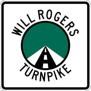
The Will Rogers Turnpike is a freeway-standard toll road in the northeast portion of the U.S. state of Oklahoma. The highway begins as a continuation of the Creek Turnpike in Tulsa, continuing northward from the I-44/US-412 interchange there to the Missouri state line west of Joplin, Missouri. The turnpike carries the I-44 designation for its entire length. The turnpike is 88.5 miles (142.4 km) long and costs $4.75 to drive one way. The Will Rogers Turnpike opened to traffic on June 28, 1957. It was designated as I-44 in 1958. It is named for Will Rogers, "Oklahoma's Favorite Son".

<span class="mw-page-title-main">Oklahoma State Highway 66</span> Highway in Oklahoma

State Highway 66 is a 192.7-mile (310.1 km) state highway in the U.S. state of Oklahoma, beginning at U.S. Highway 81 in El Reno and ending at U.S. Highway 60 near White Oak. The highway was designated in 1985 as a replacement for the decommissioned US 66. Although most of the highway follows Historic Route 66, the highway follows US 66's final alignment, joining Interstate 44 through Tulsa and Oklahoma City, while older versions of the route follow various city streets through both cities.

<span class="mw-page-title-main">Oklahoma State Highway 20</span> Highway in Oklahoma

State Highway 20 is a highway in northeastern Oklahoma. Its eastern terminus is at the corner of Oklahoma, Arkansas, and Missouri near Southwest City, Missouri; its western terminus is at State Highway 18 near Ralston. The highway runs a total length of 142.7 miles (229.7 km). It has no lettered spur routes.

<span class="mw-page-title-main">Oklahoma State Highway 51</span> State highway in Oklahoma, United States

State Highway 51, abbreviated to SH-51 or OK-51, is a major state highway in Oklahoma, United States. It runs for 332.8 miles (535.6 km) east–west across the state, running from the Texas state line to Arkansas. It is the third-longest state highway in the system.

<span class="mw-page-title-main">Oklahoma State Highway 10</span>

State Highway 10 is a state highway in northeastern Oklahoma. It makes a 233.1 miles (375.1 km) crescent through the northeast corner of the state, running from SH-99 in Osage County to Interstate 40 (I-40) near Gore. It has two lettered spur routes.

<span class="mw-page-title-main">Oklahoma State Highway 266</span>

State Highway 266 is a state highway near Tulsa, Oklahoma, United States. It runs for 10.92 miles (17.57 km) through Tulsa and Rogers Counties in northeastern Oklahoma.

<span class="mw-page-title-main">Oklahoma State Highway 152</span> Highway in Oklahoma

State Highway 152 is a state highway running through west-central Oklahoma. It begins at the Texas state line, serving as a continuation of Texas State Highway 152, and continues east to end at Interstate 44 (I-44) in southwest Oklahoma City, a length of 149.2 miles (240.1 km). Along its route it serves three county seats: Sayre, Cordell, and Oklahoma City. Near its eastern end, it passes through the Oklahoma City suburb of Mustang. The easternmost 5.2 miles (8.4 km) of the route is a freeway linking Will Rogers World Airport to the Interstate system. SH-152 has no lettered spur routes.

<span class="mw-page-title-main">Oklahoma State Highway 165</span>

State Highway 165 (SH-165) is a state highway in Muskogee County, Oklahoma. It runs east along Peak Boulevard in the southern part of Muskogee from US-64 to the northern terminus of the southern section of the Muskogee Turnpike, then runs north as a freeway connecting the two sections of the turnpike. The total length of the highway is 8.21 miles (13.21 km).

<span class="mw-page-title-main">Interstate 44 in Texas</span> Highway in Texas

Interstate 44 (I-44) in the US state of Texas has a short, but regionally important, 14.77-mile (23.77 km) stretch connecting Wichita Falls with Oklahoma. Its entire length runs concurrently with U.S. Highway 277 (US 277) and US 281. I-44 provides access to downtown Wichita Falls and Sheppard Air Force Base. I-44 is known as Central Freeway in Wichita Falls and Red River Expressway in Burkburnett.

<span class="mw-page-title-main">Oklahoma State Highway 88</span>

State Highway 88, abbreviated to SH-88 or OK-88, is a state highway in Oklahoma. It runs for 26.0 miles (42 km) north–south through Rogers County. It has no lettered spur routes.

<span class="mw-page-title-main">U.S. Route 69 in Oklahoma</span>

U.S. Route 69 is a major north-south U.S. Highway in the U.S. state of Oklahoma. It extends the corridor formed by U.S. Route 75 in Texas, from Dallas northeast via McAlester and Muskogee to the Will Rogers Turnpike near Vinita. From Vinita to the Kansas state line, US-69 generally parallels the turnpike along old U.S. Highway 66.

<span class="mw-page-title-main">U.S. Route 62 in Oklahoma</span> Highway in Oklahoma

In Oklahoma, U.S. Highway 62 (US 62) runs diagonally across the state, from the Texas state line in far southwestern Oklahoma to the Arkansas state line near Fayetteville. US-62 spends a total of 402.48 miles (647.73 km) in the Sooner State. The highway passes through fifteen of Oklahoma's counties. Along the way the route serves two of Oklahoma's largest cities, Lawton and Oklahoma City, as well as many regionally important cities, like Altus, Chickasha, Muskogee, and Tahlequah. Despite this, US-62 has no lettered spur routes like many other U.S. routes in Oklahoma do.

<span class="mw-page-title-main">U.S. Route 60 in Oklahoma</span> Section of U.S. Highway in Oklahoma, United States

U.S. Route 60 (US-60) is a transcontinental U.S. highway extending from near Brenda, Arizona to Virginia Beach, Virginia on the Atlantic Ocean. Along the way, 352.39 miles (567.12 km) of the route lies within the state of Oklahoma. The highway crosses into the state from Texas west of Arnett and serves many towns and cities in the northern part of the state, including Arnett, Seiling, Fairview, Enid, Ponca City, Pawhuska, Bartlesville, and Vinita. US-60 exits Oklahoma near Seneca, Missouri. In Oklahoma, US-60 has three business routes, serving Tonkawa, Ponca City, and Seneca. The first 60.2 miles (96.9 km) of the route, from the Texas line to Seiling, is also designated as State Highway 51 (SH-51).

<span class="mw-page-title-main">U.S. Route 412 in Oklahoma</span> Highway in Oklahoma

U.S. Route 412 is a U.S. highway in the south-central portion of the United States, connecting Springer, New Mexico to Columbia, Tennessee. A 504.11-mile (811.29 km) section of the highway crosses the state of Oklahoma, traversing the state from west to east. Entering the state southwest of Boise City, US-412 runs the length of the Oklahoma Panhandle and serves the northern portion of the state's main body, before leaving the state at West Siloam Springs. Along the way, the route serves many notable cities and towns, including Boise City, Guymon, Woodward, Enid, and the state's second-largest city, Tulsa.

<span class="mw-page-title-main">U.S. Route 64 in Oklahoma</span> Highway in Oklahoma

U.S. Route 64 (US-64) is a U.S. highway running from the Four Corners area to the Outer Banks of North Carolina. Between these two points, the highway passes through the entire width of Oklahoma; a total of 591.17 miles (951.40 km) of US-64 lies in the state of Oklahoma. US-64 enters the state from New Mexico, crossing the line between the two states between Clayton, New Mexico, and Boise City in Cimarron County. The route runs the full length of the Oklahoma Panhandle, then serves the northernmost tier of counties in the main body of the state before dipping southeastward to Tulsa, the state's second-largest city. From Tulsa, the highway continues southeast, leaving Oklahoma just west of Fort Smith, Arkansas. In addition to Tulsa, US-64 serves fifteen Oklahoma counties and the cities of Guymon, Woodward, Enid, and Muskogee.

<span class="mw-page-title-main">U.S. Route 75 Alternate (Beggs–Sapulpa, Oklahoma)</span>

U.S. 75 Alternate is a 30.15-mile (48.52 km) highway near Tulsa. The southern terminus is at U.S. Highway 75 and SH-16 east of Beggs. The northern terminus is signed at State Highway 66 and State Highway 97 in Sapulpa. However, the highway continues unsigned along SH-66, ending at the north terminus of the Turner Turnpike, where SH-66 merges onto the free portion of I-44. It runs parallel to US-75 for its entire length.

References

  1. Oklahoma Department of Transportation. "State Highway System: Log of U.S. Highway 169" (PDF). Retrieved September 27, 2012.
  2. Official State Map (PDF) (Map) (2011–12 ed.). Oklahoma Department of Transportation. Retrieved October 4, 2012.
  3. Federal Highway Administration (2012). "NBI Structure Number: 152010000000000". National Bridge Inventory. Federal Highway Administration.
  4. Federal Highway Administration (2012). "NBI Structure Number: 152020000000000". National Bridge Inventory. Federal Highway Administration.
  5. 1 2 Oklahoma Department of Transportation (n.d.). Control Section Maps: Tulsa County (PDF) (Map) (2010–2011 ed.). Scale not given. Oklahoma City: Oklahoma Department of Transportation. Retrieved October 4, 2012.
  6. Oklahoma Department of Transportation (n.d.). Control Section Maps: Rogers County (PDF) (Map) (2010–2011 ed.). Scale not given. Oklahoma City: Oklahoma Department of Transportation. Retrieved October 4, 2012.
  7. 1 2 Oklahoma Atlas and Gazetteer (Map). 1:200,000. DeLorme. 2006.
  8. 1 2 Google (September 29, 2012). "U.S. Route 169 in Oklahoma" (Map). Google Maps . Google. Retrieved September 29, 2012.
  9. Oklahoma Department of Transportation, Planning & Research Division. "Memorial Dedication & Revision History - US-169" . Retrieved October 19, 2012.
  10. Map Showing Condition of Improvement of the State Highway System and Landing Fields (PDF) (Map) (October 1935 ed.). Oklahoma Department of Highways. Retrieved October 25, 2012.
  11. Map Showing Condition of Improvement of the State Highway System and Landing Fields (PDF) (Map) (May 1936 ed.). Oklahoma Department of Highways. Retrieved October 25, 2012.
  12. Google (September 29, 2012). "U.S. Route 169 in Oklahoma" (Map). Google Maps . Google. Retrieved September 29, 2012.

Route map:

Template:Attached KML/U.S. Route 169 in Oklahoma
KML is from Wikidata